Rockdale, New South Wales facts for kids
Quick facts for kids RockdaleSydney, New South Wales |
|||||||||||||||
|---|---|---|---|---|---|---|---|---|---|---|---|---|---|---|---|

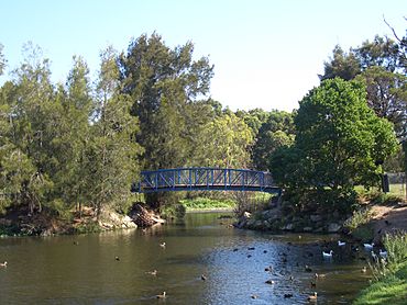
Bicentennial Park, Rockdale
|
|||||||||||||||
| Population | 15,534 (2016 census) | ||||||||||||||
| • Density | 6,470/km2 (16,800/sq mi) | ||||||||||||||
| Established | 1887 | ||||||||||||||
| Postcode(s) | 2216 | ||||||||||||||
| Elevation | 20 m (66 ft) | ||||||||||||||
| Area | 2.4 km2 (0.9 sq mi) | ||||||||||||||
| Location | 13 km (8 mi) south of Sydney CBD | ||||||||||||||
| LGA(s) | Bayside Council | ||||||||||||||
| State electorate(s) | Rockdale | ||||||||||||||
| Federal Division(s) | Barton | ||||||||||||||
|
|||||||||||||||
Rockdale is a cool suburb located in southern Sydney, New South Wales, Australia. It's about 13 kilometres south of the main city centre, known as the Sydney CBD. Rockdale is part of the St George area and is one of the main spots for the Bayside Council, which helps run the local area. Since 1985, Rockdale has been a "twinned city" with Bitola in North Macedonia. This means they share a special friendship and cultural exchange!
Contents
Rockdale's Past: A Journey Through Time
Rockdale has had a few different names over the years. Early European settlers called it Frog Hollow, then White Gum Flat, and later West Botany. The name Rockdale was first suggested in 1878 by Mary Ann Geeves, who was the first postmistress here.
The name became official when the local railway station opened on 15 October 1884. The area's local government, which started in 1871 as the West Botany Municipality, officially changed its name to "The Municipality of Rockdale" in 1888.
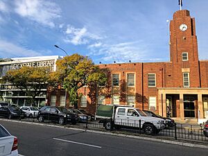
The first council building was built in 1872. Later, a new building was put up where the current Rockdale Town Hall stands today. That building was then rebuilt in 1940 to become the Town Hall we see now.
Mary Ann Geeves, a pioneer and the first postmistress, was key in naming Rockdale. Her husband, Yeoman Geeves, helped build Rocky Point Road. Their family lived near where the Princes Highway is today, and they ran the first post office in the area in 1882.
More homes started to appear after the railway opened in 1884. A significant property developer back then was Frederick Jamison Gibbes, who was also a Member of Parliament. You can find Gibbes Street in Banksia named after him!
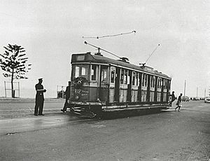
For many years, an electric tramway ran from Rockdale Station down Bay Street to Brighton-Le-Sands. This tram line operated until 1949. In 1948, the councils of Rockdale and Bexley joined together. The area became the City of Rockdale in 1995, and then in 2016, it merged with the City of Botany Bay to form the Bayside Council.
Historic Places to See
Rockdale has some cool heritage-listed spots that are important to its history:
- Rockdale railway station: Part of the Illawarra railway line.
- Lydham Hall: Located at 18 Lydham Avenue.
- Kyeemagh Market Gardens: Found on Occupation Road.
- Wilsons Farm House: Located at 310 West Botany Street.
Rockdale's Bustling Centre: Shops and More
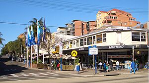
Rockdale is a mix of homes, shops, and light industrial areas. The main shopping street is along the Princes Highway, right next to the railway station. The shopping area also spreads into nearby streets and on the other side of the railway line. King Street has become a lovely spot with cafes and grocery stores. You'll also find commercial buildings along parts of Bay Street and West Botany Street. The light industrial areas are mostly around West Botany Street.
If you love shopping, check out Rockdale Plaza. It's a shopping centre located on Princes Highway in the southern part of the suburb.
You can also see some cool Art Deco buildings in Rockdale, like the Rockdale Town Hall and the St George Tavern. The Town Hall was designed by a local architect named Douglas Gardiner and built in 1940.
Who Lives in Rockdale?
According to the 2021 Australian Census, there were 15,475 people living in Rockdale. About 33.5% of these people were born in Australia. Many others came from countries like Nepal (15.8%), China (6.5%), North Macedonia (3.5%), Bangladesh (3.4%), and the Philippines (3.2%).
While 28% of people spoke only English at home, many other languages are spoken too! These include Nepali (16.1%), Mandarin (5.5%), Macedonian (5.2%), Arabic (4.6%), and Cantonese (4.1%). When it comes to religion, the most common responses were No Religion (21.0%), Hinduism (18.2%), Catholic (16.4%), Islam (10.6%), and Eastern Orthodox (9.9%).
Getting Around Rockdale
The Princes Highway is the main road that goes through Rockdale. West Botany Street runs parallel to it on the east side. Bay Street connects Rockdale to General Holmes Drive at Brighton-le-Sands.
Rockdale railway station is on the Illawarra line of the Sydney Trains network. This makes it easy to get around! Rockdale is also a big hub for Transit Systems buses, which can take you to places like Westfield Miranda, Brighton-Le-Sands, Westfield Burwood, and Mascot station. U-Go Mobility also runs buses to Hurstville.
It takes about 20 minutes to get to the Sydney CBD by public transport and around 25 minutes by car.
The Old Rockdale to Brighton-Le-Sands Tram Line
Did you know Rockdale used to have a tram line? This line opened in 1885 as a private steam tramway. It was later updated to an electric tram in 1900 and became government-owned in 1914.
The tram connected with trains at Rockdale station and then went down Bay Street to Brighton-Le-Sands. It was a single track with a loop at each end for trams to pass. The tram line closed in 1949 and was replaced by a bus service, which still runs today! There was a small depot in Rockdale where the trams were kept and maintained.
Rockdale also has a service called St George Community Transport. This helps older people, people with disabilities, and their carers get around.
 | Valerie Thomas |
 | Frederick McKinley Jones |
 | George Edward Alcorn Jr. |
 | Thomas Mensah |


