
Kyeemagh facts for kids
Quick facts for kids KyeemaghSydney, New South Wales |
|||||||||||||||
|---|---|---|---|---|---|---|---|---|---|---|---|---|---|---|---|

Muddy Creek
|
|||||||||||||||
| Population | 919 (2016 census) | ||||||||||||||
| Postcode(s) | 2216 | ||||||||||||||
| Elevation | 7 m (23 ft) | ||||||||||||||
| Location | 12 km (7 mi) south of Sydney CBD | ||||||||||||||
| LGA(s) | Bayside Council | ||||||||||||||
| State electorate(s) | Rockdale | ||||||||||||||
| Federal Division(s) | Barton | ||||||||||||||
|
|||||||||||||||
Kyeemagh is a suburb in southern Sydney, New South Wales, Australia. It is about 12 kilometres south of the main city area of Sydney. Kyeemagh sits on the western shore of Botany Bay. It is part of the Bayside Council area and is known as part of the St George region. The name Kyeemagh comes from an Aboriginal word meaning 'beautiful dawn'.
Contents
A Look at Kyeemagh's Past
Before European settlers arrived, the land where Kyeemagh now stands belonged to the Cadigal people. The name 'Kyeemagh' was officially adopted for the suburb because of a polo ground built there in 1929. A new bridge was built over the Cooks River in 1930 to make it easier to reach this polo ground. People also used the polo ground for playing cricket.
In the 1920s, this area was known as North Brighton. Maps from that time show the streets that existed. The whole area between the Cooks River and Georges River was once called Seven Mile Beach. In 1874, its name was changed to Lady Robinson's Beach to honor the wife of Governor Sir Hercules Robinson. Cook Park, a popular public area, is named after Samuel Cook, who worked hard to make it a park for everyone.
Early Land Use and Changes
In 1837, a man named John Webb was given a large piece of land, about 300 acres (1.2 square kilometres). However, he did not settle there because the land was too dry and scrubby for farming. Later, in 1882, about 309 acres (1.25 square kilometres) were set aside for a sewage farm. More land was added to this farm later. The sewage farm stopped being used in 1916 when a new system was built to send waste out to the ocean. After that, the land was divided up for building homes.
John Goode owned property on West Botany Street. He built a private road from his property to Seven Mile Beach, which was the name for Lady Robinsons Beach back then. This road was named Goode Street in his honor. However, it was later renamed Bestic Street. Old maps from the 1920s show another street named after John Goode, which was off Bestic Street.
Exploring Kyeemagh's Geography
Kyeemagh is a quiet place where people live. It is shaped like a triangle of land. To the east, you'll find Lady Robinsons Beach. The Cooks River and Muddy Creek form the boundary to the northwest. Bestic Street borders the south of the suburb.
Early maps from 1909 and 1915 show that there wasn't much development in the area. But by 1925 and 1928, maps showed a very crowded settlement called Filby Estate. This estate was located between Goode Street and the bay. Streets like Adair Street and Annie Street ran east from Goode Street. Other streets included Coy, Derby, Henry, and William Streets. There were also many small lanes and walking paths. However, none of these old streets or paths still exist today. This crowded settlement was later replaced by the larger, less crowded suburb we know as Kyeemagh. Buses used to connect this area to the shopping centers in Rockdale and Brighton Le Sands.
Important Places and Landmarks
Kyeemagh is located on the southern side of the Cooks River and the eastern side of Muddy Creek. Lady Robinsons Beach and Cook Park stretch along the eastern edge of the suburb. You can find a small group of shops on Bestic Street, close to General Holmes Drive. Other green spaces in Kyeemagh include Kyeemagh Reserve and Lance Stoddert Reserve.
The Brighton Le Sands Amateur Fisherman's Association and TS Sirius, which is an Australian Navy Cadet unit, are both located on Bestic Street, right next to Muddy Creek. The C-side restaurant, which is part of the Cyprus-Hellene Club, is located in Cooks Park on General Holmes Drive, very close to the beach.
The Endeavour Bridge connects Kyeemagh to Sydney Airport, Botany, and Mascot. The entrance to the M5 Motorway is also in Kyeemagh. This motorway connects to places like Arncliffe, Kingsgrove, Beverly Hills, and further west to Liverpool and Campbelltown. Kyeemagh Public School is located on Beehag and Jacobson Avenues, serving the local students.
Who Lives in Kyeemagh?
According to the 2016 census, there were 919 people living in Kyeemagh. The most common backgrounds reported by residents were Greek (19.7%), Australian (14.0%), English (10.0%), Lebanese (6.2%), and Italian (5.2%). About 56.3% of the people living in Kyeemagh were born in Australia.
When it comes to languages spoken at home, 43.6% of people spoke only English. Other languages spoken at home included Greek, which was spoken by 21.4% of residents. For religious beliefs, the most common responses were Eastern Orthodox (27.0%), Catholic (24.5%), and No Religion (14.2%).
Images for kids
-
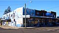
Shops on Bestic Street
-
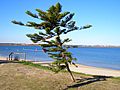
Lady Robinson Beach, Cook Park
-
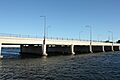
Endeavour Bridge and Cooks River


