
Mascot, New South Wales facts for kids
Quick facts for kids MascotSydney, New South Wales |
|||||||||||||||
|---|---|---|---|---|---|---|---|---|---|---|---|---|---|---|---|

Bourke Road
|
|||||||||||||||

Mascot
Location in Sydney
|
|||||||||||||||
| Population | 21,591 (2021 census) | ||||||||||||||
| • Density | 1,605.7/km2 (4,159/sq mi) | ||||||||||||||
| Established | 1911 | ||||||||||||||
| Postcode(s) | 2020 | ||||||||||||||
| Elevation | 10 m (33 ft) | ||||||||||||||
| Area | 9.2 km2 (3.6 sq mi) | ||||||||||||||
| Location | 7 km (4 mi) from Sydney CBD | ||||||||||||||
| LGA(s) | Bayside Council, Inner West Council (minor) | ||||||||||||||
| State electorate(s) | Heffron | ||||||||||||||
| Federal Division(s) | Kingsford Smith | ||||||||||||||
|
|||||||||||||||
Mascot is a busy suburb located in the southern part of Sydney, in New South Wales, Australia. It's about 7 kilometres south of the main city centre, known as the Sydney central business district. Mascot is an important area for the Bayside Council, which helps manage the local community. A small part of Sydney Airport, which is in Mascot, is also managed by the Inner West Council. Mascot is close to Botany Bay and is home to the huge Sydney Airport.
Contents
Mascot's History


The first land in Mascot was given out in 1835. Back then, people mostly used the land for growing vegetables. As more people moved in, new areas were created for houses, especially after Botany Road was built in 1875.
How Mascot Got Its Name
In 1888, the area became a local government area called North Botany. There was also a racecourse here in 1904, named Ascot, after a very famous racecourse in England.
In 1911, people wanted to give the area a new, unique name. They voted between "Ascot" and "Booralee". However, the postal service didn't want the name "Ascot". So, the council changed the name to Mascot, which is what it's called today!
The Story of Sydney Airport
In 1920, Mascot was chosen as the perfect spot for a public airport. The government bought land for this purpose in 1921. The first regular flights started in 1924.
By 1935, Mascot became the main base for Qantas, a major Australian airline. To make more space for the growing airport, the Cooks River was moved between 1947 and 1953.
Important Heritage Sites
Mascot has some places that are protected because of their history. These include:
- 1024 Botany Road: Part of the Botany Water Reserves
- General Holmes Drive: Sewage Pumping Station 38
Mascot's Commercial Hub


Mascot is a mix of homes, shops, and businesses. The main shopping area is found along Botany Road. The area around Mascot railway station is also being updated with new buildings for businesses and homes.
The local police headquarters are on Botany Road. You can also find the Mascot Ambulance Station and the Mascot Fire Station nearby.
Sydney Airport and Qantas
Sydney Airport is Australia's biggest airport. It's a very important part of Mascot and provides many jobs. The main office for Qantas is called the Qantas Centre, located on Coward Street in Mascot. There are also many hotels in the suburb for people travelling through the airport.
Getting Around Mascot
Mascot has good transport options, making it easy to get around.
Buses
Many bus routes serve Mascot. These buses travel along main roads like Botany Road and Gardeners Road. There's also a bus that starts from the Qantas Centre.
Trains
Mascot has three train stations on the Airport & South Line:
- Mascot railway station: This station is in the main part of the suburb where people live and work.
- International Airport Station and Domestic Airport Station: These stations are located right under the airport terminals.
Bike Paths
There are also bicycle paths in Mascot. You can ride your bike from Mascot to the M5 East Freeway at Arncliffe. Other paths connect Mascot to Botany Bay, the University of New South Wales, and the Sydney CBD.
Mascot's Population
In 2021, about 21,591 people lived in Mascot.
- About 35.1% of people were born in Australia.
- Many people were born in other countries, including China (11.4%), Indonesia (9.8%), Mongolia (2.6%), India (2.6%), and Ireland (2.2%).
- About 37.9% of people spoke only English at home.
- Other languages spoken include Mandarin (12.5%), Indonesian (8.3%), Cantonese (4.2%), Spanish (3.8%), and Greek (2.7%).
- For religion, 34.7% said they had no religion, and 23.5% were Catholic.
- Most homes in Mascot (74.3%) are flats or apartments.
Famous People from Mascot
Mascot has been home to several notable people, including:
- Jim Breen, a rugby league player
- Thomas Bulch, a musician
- Mick Craigie, a rugby league player
- Eric Cremin, a golfer
- Ron Hoenig, a lawyer and politician
- Tom Howard, a golfer
- Amber Lawrence, a musician
- Jack Lindwall, a rugby league player
- Ray Lindwall, a famous cricketer and rugby league player
- George Piggins, a rugby league player and administrator
- Amber-Jade Sanderson, a politician
- Sione Tovo, a rugby league player
Schools in Mascot
Mascot has several schools for students:
- Mascot Public School (primary school) on King Street.
- J. J. Cahill Memorial High School on Sutherland Street.
- St Therese School Mascot on Sutherland Street.
- Gardeners Road Primary School, which is close by and also has students from Mascot.
Places of Worship
Mascot has different places where people can worship:
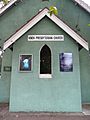
- Knox Presbyterian Church, built in 1911.
- Self-Realization Fellowship Sydney Centre.
- St Catherine's Greek Orthodox Church.
Parks and Fun Activities
Mascot has great places for sports and recreation:
- L'Estrange Park is home to the Mascot Kings (soccer) team and the Mascot Juniors rugby league team.
- Mascot Oval is where the Mascot Juniors play their home games.
- The Lakes Golf Club is a well-known golf course that has hosted many big golf tournaments.
Gallery
-
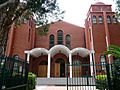
St Catherine's Greek Orthodox Church, Coward Street
-
Knox Presbyterian Church, Botany Road
-
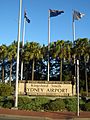
Entrance to Sydney Airport
-
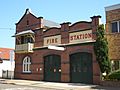
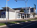
Mascot Fire Station, Coward Street
-
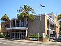
Council Chambers, Coward Street
-
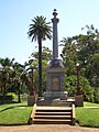
Mascot Memorial Park, Botany Road
-
Mascot railway station


Mascot's Climate
Mascot has a humid subtropical climate. This means it has warm summers and mild winters. The area gets about 104 clear days and 129 cloudy days each year.
| Climate data for Sydney Airport (Eastern Sydney) | |||||||||||||
|---|---|---|---|---|---|---|---|---|---|---|---|---|---|
| Month | Jan | Feb | Mar | Apr | May | Jun | Jul | Aug | Sep | Oct | Nov | Dec | Year |
| Record high °C (°F) | 46.4 (115.5) |
42.9 (109.2) |
41.2 (106.2) |
35.7 (96.3) |
29.1 (84.4) |
25.6 (78.1) |
26.7 (80.1) |
30.9 (87.6) |
35.9 (96.6) |
39.1 (102.4) |
43.4 (110.1) |
43.2 (109.8) |
46.4 (115.5) |
| Mean daily maximum °C (°F) | 27.7 (81.9) |
27.1 (80.8) |
25.8 (78.4) |
23.3 (73.9) |
20.6 (69.1) |
18.1 (64.6) |
17.7 (63.9) |
19.1 (66.4) |
21.6 (70.9) |
23.6 (74.5) |
24.6 (76.3) |
26.4 (79.5) |
23.0 (73.4) |
| Daily mean °C (°F) | 23.8 (74.8) |
23.5 (74.3) |
22.1 (71.8) |
19.2 (66.6) |
16.3 (61.3) |
13.9 (57.0) |
13.7 (56.7) |
14.2 (57.6) |
16.7 (62.1) |
19.0 (66.2) |
20.5 (68.9) |
22.4 (72.3) |
18.8 (65.8) |
| Mean daily minimum °C (°F) | 20.0 (68.0) |
20.0 (68.0) |
18.5 (65.3) |
15.2 (59.4) |
12.1 (53.8) |
9.8 (49.6) |
8.5 (47.3) |
9.3 (48.7) |
11.9 (53.4) |
14.4 (57.9) |
16.5 (61.7) |
18.4 (65.1) |
14.5 (58.1) |
| Record low °C (°F) | 13.0 (55.4) |
12.0 (53.6) |
8.8 (47.8) |
7.1 (44.8) |
3.8 (38.8) |
2.2 (36.0) |
0.8 (33.4) |
3.2 (37.8) |
5.1 (41.2) |
6.0 (42.8) |
7.6 (45.7) |
11 (52) |
0.8 (33.4) |
| Average rainfall mm (inches) | 80.7 (3.18) |
117.2 (4.61) |
96.3 (3.79) |
98.2 (3.87) |
89.3 (3.52) |
125.9 (4.96) |
69.5 (2.74) |
63.3 (2.49) |
59.0 (2.32) |
55.5 (2.19) |
72.3 (2.85) |
67.1 (2.64) |
996.2 (39.22) |
| Average rainy days (≥ 1 mm) | 7.8 | 8.6 | 9.4 | 8.2 | 7.6 | 8.9 | 7.0 | 5.4 | 6.3 | 7.4 | 8.6 | 7.9 | 93.1 |
| Average afternoon relative humidity (%) | 59 | 62 | 60 | 58 | 59 | 58 | 53 | 46 | 49 | 52 | 56 | 57 | 56 |
| Mean monthly sunshine hours | 235.6 | 202.4 | 213.9 | 207.0 | 195.3 | 177.0 | 204.6 | 244.9 | 237.0 | 244.9 | 228.0 | 244.9 | 2,635.5 |
| Source 1: Bureau of Meteorology (records) | |||||||||||||
| Source 2: Bureau of Meteorology (1991-2020 averages) | |||||||||||||
