
Alexandria, New South Wales facts for kids
Quick facts for kids AlexandriaSydney, New South Wales |
|||||||||||||||
|---|---|---|---|---|---|---|---|---|---|---|---|---|---|---|---|

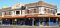
Parkview Hotel, Mitchell Road
|
|||||||||||||||

Alexandria
Location in New South Wales
|
|||||||||||||||
| • Density | 1,540/km2 (4,000/sq mi) | ||||||||||||||
| Postcode(s) | 2015 | ||||||||||||||
| Elevation | 15 m (49 ft) | ||||||||||||||
| Area | 3.8 km2 (1.5 sq mi) | ||||||||||||||
| Location | 4 km (2 mi) south of Sydney CBD | ||||||||||||||
| LGA(s) | City of Sydney | ||||||||||||||
| State electorate(s) |
|
||||||||||||||
| Federal Division(s) | Sydney | ||||||||||||||
|
|||||||||||||||
Alexandria is a suburb located in the inner southern part of Sydney, New South Wales, Australia. It is about 5 kilometres south of the main city centre, known as the Sydney central business district. Alexandria is part of the City of Sydney local government area. Its postcode is 2015.
The main borders of Alexandria are Botany Road to the east and Gardeners Road to the south. To the west, you'll find Mitchell Road and Sydney Park. Boundary Road marks the northern edge. It's also quite close to Central Station, about 3.5 kilometres away.
Contents
History of Alexandria
How Alexandria Got Its Name
The area of Alexandria was officially named in 1835. It was named after the famous Battle of Alexandria. This battle was a big British victory against Napoleon. A nearby suburb, Waterloo, also gets its name from another famous battle against Napoleon.
You can even find the Iron Duke Hotel in Alexandria. It's named after the Duke of Wellington. He was a famous general who won the Battle of Waterloo.
Alexandria's Own Council
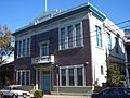
In 1868, Alexandria formed its own local council, called the Municipality of Alexandria. Before this, it was part of Waterloo. The old Alexandria Town Hall building is on Garden Street. It was built in 1881 and has been changed a few times since. This building is now a protected heritage site.
Alexandria as an Industrial Hub
By 1943, Alexandria was a very important industrial area in Australia. It was even called the "Birmingham of Australia." This means it was a major centre for factories and manufacturing. Over 550 factories made all sorts of things, from bricks to aeroplanes.
In 1949, Alexandria's local council joined with the City of Sydney. The boundaries changed a few times over the years. Finally, in 2004, Alexandria became part of the City of Sydney once more.
Trams in Alexandria


Long ago, trams were a popular way to travel in Sydney. The Alexandria tram line opened in 1902. It was an electric line that ran through Henderson Road and Mitchell Road. It connected to other tram lines and went all the way to the Princes Highway near St Peters railway station.
Trams from Alexandria could take you to places like Circular Quay. However, the tram line in Alexandria closed down in 1959. Today, the Transit Systems bus route 308 follows a similar path to the old tram line.
Heritage Listings
Alexandria has several places that are important to its history and are officially protected. These include:
- Alexandra Canal
- 39 Brandling Street: Enginemans Resthouse
- 16-22 Retreat Street: Yiu Ming Temple
People of Alexandria (Demographics)
In 2021, there were 9,649 people living in Alexandria. This was an increase from 8,262 people in 2016.
Most people in Alexandria have Australian, English, or Irish backgrounds. About 60% of residents were born in Australia. Other common birthplaces include England, New Zealand, and China.
English is the main language spoken at home by most people (74.1%). Other languages include Mandarin, Spanish, and Cantonese. When it comes to religion, many people (57.2%) reported having no religion. The most common types of homes in Alexandria are flats (apartments) and semi-detached houses.
Commercial and Business Areas
Alexandria used to be mostly a place for factories and warehouses. While it still has many industrial areas, it also has more homes now. In the past, there were many terraced houses, but some were replaced by light industrial buildings. You can still find quiet residential streets, especially near Erskineville and Waterloo.
An interesting fact is that one of the places where the Southern Cross Cable connects to Australia is in Alexandria. This cable helps carry internet and phone signals across the Pacific Ocean.
Green Square Development
Part of Alexandria is in the Green Square area. This area is going through a big change called urban renewal. This means old parts are being updated with new shops, businesses, and modern apartments. It's making the area more lively and modern.
South Sydney Markets
The South Sydney Markets started in 2009. They were a place for the community to buy fresh food and handmade crafts. They also had fun activities for kids, like face painting and a small zoo. The markets were open every Sunday on O'Riordan Street. Unfortunately, they are currently closed.
Getting Around (Transport)
Alexandria is well-connected by public transport. Buses run by Transdev John Holland can take you to the Sydney central business district.
There are also two train stations close by. Green Square railway station is on the north-eastern side of Alexandria. It's on the Airport & South Line. Erskineville railway station and St Peters railway station are to the west. They are on the Bankstown Line. Both stations are easy to walk to from Alexandria.
Culture
- Alexandria is home to the main office for the Serbian Orthodox Eparchy of Australia and New Zealand.
- There is a Chinese community in Alexandria. It is based around the Yiu Ming Temple on Retreat Street. This temple and the houses nearby are heritage-listed.
Sport and Recreation
Sydney Park is a large park on the western edge of Alexandria. It's a great place for outdoor activities. Alexandria Park and McKell Playground are on Buckland Street. Here you can find tennis courts and a cricket oval.
Erskineville Oval is very close by, just over the western border. It's the home ground for the Alexandria Rovers junior rugby league team. The Alexandria Dukes Rugby Football Club also plays rugby in the area. Their club rooms are at the Iron Duke Hotel.
Gallery
-
The old Alexandria Town Hall on Garden Street.
-
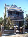
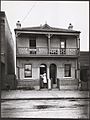
A Victorian terrace house on Garden Street.
-
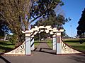
Alexandria Park on Wyndham Street.
-
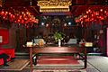
The Yiu Ming Temple on Retreat Street.
-
The Lord Raglan Hotel on Henderson Road.
-
The former Alexandria Baby Clinic.
-
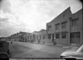
Bestex Mills in Alexandria, pictured in 1951.


Yiu_Ming_Temple-2.jpg)

.jpg)

