
Circular Quay facts for kids

Circular Quay from the Sydney Harbour Bridge
|
|

Location in Sydney
|
|
| Other name(s) | Sydney Cove |
|---|---|
| Part of | Port Jackson |
| Type |
|
| Owner | Property NSW |
| Location | Sydney central business district, City of Sydney, New South Wales, Australia |
| Coordinates | 33°51′40″S 151°12′40″E / 33.861°S 151.211°E |
| Construction | |
| Construction start | 1837 |
| Completion | 1844 |
| Other | |
| Known for | Sydney New Year's Eve |
Circular Quay is a famous waterfront area in Sydney, New South Wales, Australia. It's located right on Sydney Cove, which is part of Port Jackson. This busy spot is found on the northern edge of Sydney's main business district.
Circular Quay is a popular place for visitors and locals alike. It has lovely walkways, open spaces, parks, and many restaurants. It's also a major transport hub, with ferry wharves, bus stops, and a train station. Many people call it the "gateway to Sydney" because it offers amazing views of the Sydney Harbour Bridge and the Sydney Opera House. It's also a top spot to watch the incredible Sydney New Year's Eve fireworks!
Contents
History of Circular Quay
First Peoples: Indigenous History
The original name for Circular Quay in the Aboriginal language is Warrung, which means "Little Child". Long before Europeans arrived, Aboriginal Australians lived in and around Sydney. Evidence shows they have been here for at least 30,000 years, possibly even up to 50,000 years!
Before the British came, between 4,000 and 8,000 Aboriginal people lived in the Sydney area. They belonged to about 29 different clans. The Cadigal clan lived in the area from Sydney Cove to Petersham. They were part of larger language groups like Darug, Guringai, and Dharawal. Early European visitors saw these people camping, fishing, using trees for food and bark, and cooking fish. The Eora people are the coastal Aboriginal groups of the Sydney area.
Early European Settlement

Sydney Cove, where Circular Quay is located, was the very first place the First Fleet landed in Port Jackson on January 26, 1788. This event marked the start of European settlement in Australia.
The first governor's temporary house was built on the east side of the cove. The western side became the main area for the early settlement. Sydney grew from this central point. The first wharf (a place where ships dock) was likely built around 1792. It was later replaced by a timber wharf in 1802, which was the colony's first public wharf.
The eastern side of the cove was mostly empty in the early years. One important person who lived there was Bennelong, an Aboriginal man. The nearby Bennelong Point is named after him. In the early 1800s, the entire eastern shore was part of the Governor's Domain (his private land). However, some businesses started to appear along the shoreline.
The western shore was much busier because it was next to the first settlement, now known as The Rocks. Cadman's Cottage, built in 1816, is a building from that time that still stands today. It shows where the natural western shore of Circular Quay used to be before changes were made.
From Working Port to Passenger Hub


Circular Quay was built between 1837 and 1844. Workers reshaped the southern part of Sydney Cove, creating an artificial shoreline. The mouth of the Tank Stream, a natural waterway, was filled in. The harbour was first called "Semi-Circular Quay" because of its curved shape, but the name was later shortened to Circular Quay.
Wharves were built on the southern shore. The Customs House, where taxes on goods were collected, was built here in 1844–1845. This showed how important Circular Quay was as Sydney's main harbour. The eastern side of the cove was used as a quarry during construction.
After the governor's home moved in the 1840s and 1850s, Macquarie Street was extended north. This led to the area becoming a busy commercial wharf, especially for the wool trade. Wool stores and warehouses appeared. The historic "Moore Steps" were built in 1868, connecting the shore to Macquarie Street. By the 1860s, all three sides of Circular Quay were filled with wharves and warehouses.
However, by the 1870s, many large commercial ships started moving to Darling Harbour. Darling Harbour was bigger and had a railway line, which made it easier to transport goods. With fewer commercial ships, Circular Quay became more focused on passenger transport. The first ferry wharf was built in 1879. By the 1890s, ferry terminals dominated the harbour, and Circular Quay became the main hub for Sydney's ferry network.
Modern Transport and Buildings

Circular Quay's look changed a lot starting in 1936. A railway bridge was built, and later the elevated Cahill Expressway was added above it. Circular Quay railway station opened in 1956, and the Cahill Expressway opened in 1958.
The construction of the railway bridge meant that the old Maritime Services Board building had to be pulled down. A new one was built in 1940, which is now the Museum of Contemporary Art. The Sydney Cove Passenger Terminal was built between 1958 and 1960 for the growing number of ship passengers. Large cruise ships still dock here today.
From the 1950s, the wool stores on East Circular Quay were replaced with modern commercial buildings. The height limit for buildings in Sydney was increased in 1959. This led to some of Sydney's first skyscrapers being built around Circular Quay. The AMP Building, finished in 1962, was Sydney's tallest building at the time. In 1973, the famous Sydney Opera House was completed nearby.
In recent years, there have been many new building projects around Circular Quay. These include new offices, apartments, and hotels, further changing the area's skyline. The Sydney Opera House has also undergone major updates.
Transport at Circular Quay


Circular Quay is a very important transport hub in Sydney. It connects ferry, train, and bus services. The Cahill Expressway is a big part of the quay, running over the train station and connecting to the Sydney Harbour Bridge.
The Overseas Passenger Terminal is where large cruise ships and ocean liners dock. This allows many international visitors to arrive right in the heart of Sydney.
Circular Quay railway station is unique because it's the only train station on the City Circle line that is above ground. From its platform, you get amazing views of Sydney Harbour, including the bridge and the Opera House.
The ferry complex has five wharves. It's the starting point for almost all public ferry routes across Sydney Harbour and the Parramatta River.
Circular Quay was also a major tram hub in the past. Many electric tram services ended here. When trams were replaced by buses, the tram terminus became a big bus stop. In 2019, the new CBD and South East Light Rail opened, with a stop right on Alfred Street at Circular Quay.
Culture and Celebrations
Circular Quay is a central spot for community events and celebrations in Sydney. Because it's located between the Sydney Opera House and the Sydney Harbour Bridge, it's one of the main places where people gather for Sydney New Year's Eve fireworks.
The area is also home to the Museum of Contemporary Art and the City of Sydney Library, which is inside the historic Customs House. The Sydney Writers Walk is a series of plaques along the footpath that celebrate writers connected to Sydney.
In 2006, a large outdoor art exhibition called the Berlin Buddy Bears visited Circular Quay. Each bear represented a country from the United Nations, showing ideas of peace, freedom, and friendship.
Circular Quay is even mentioned in songs! The classic song "And the Band Played Waltzing Matilda" by Eric Bogle and a song called "Circular Quay" by Dr. Robert of The Blow Monkeys both feature this famous location.
Every year, Australian Water Polo holds an event called Water Polo by the Sea here. The Australia men's national water polo team plays against the International All Stars in the harbour.
Images for kids
-
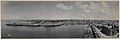
Panorama of Circular Quay from a ship's mast, 1903, by Melvin Vaniman
-
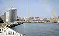
Circular Quay in 1963, viewed from the northeast.
-
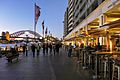
East Circular Quay waterfront in the early 21st century.
.jpg)

