
The Rocks, New South Wales facts for kids
Quick facts for kids The RocksSydney, New South Wales |
|||||||||||||||
|---|---|---|---|---|---|---|---|---|---|---|---|---|---|---|---|
,_The_Rocks_--_2019_--_2133.jpg)
The Rocks, Sydney
|
|||||||||||||||
| Postcode(s) | 2000 | ||||||||||||||
| Area | 0.2 km2 (0.1 sq mi) | ||||||||||||||
| Location | 1 km (1 mi) from Sydney CBD | ||||||||||||||
| LGA(s) | City of Sydney | ||||||||||||||
| Parish | St Philip | ||||||||||||||
| State electorate(s) | Sydney | ||||||||||||||
| Federal Division(s) | Sydney | ||||||||||||||
|
|||||||||||||||
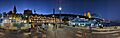
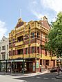
The Rocks is a really old and interesting part of Sydney, Australia. It's right on the southern shore of Sydney Harbour, just north-west of the main city centre. It's a popular spot for tourists because of its history and cool shops.
Contents
Where is The Rocks?
The area called "The Rocks" is on the western side of Sydney Cove, which is near Circular Quay. It stretches east from the Sydney Harbour Bridge and goes down to Jamison Street. It also includes an area known as "Church Hill."
A Look Back in Time: The History of The Rocks


The Rocks started to grow very soon after the first European settlement in Australia in 1788. The local Cadigal people knew this place as Tallawoladah. The first homes were simple, made from mud and sticks, with roofs of straw. Later, buildings were made from local sandstone, which is how the area got its name, "The Rocks."
From the very beginning, this area was known as a tough place. Many arriving convicts lived here, and sailors often visited. By 1823, about 1,200 people lived in The Rocks. In the late 1800s, a group called the Rocks Push was well-known here. The area kept its rough reputation until about the 1870s.
By the early 1900s, many old buildings were falling apart. In 1900, a serious illness called the bubonic plague broke out. The government decided to buy land around The Rocks to knock down old buildings and build new ones. Hundreds of buildings were destroyed, but these plans stopped when World War I began. Later, in the 1920s, more buildings were taken down to make way for the Sydney Harbour Bridge.


In the 1960s, a new group called the Sydney Cove Redevelopment Authority wanted to knock down most of the old buildings in The Rocks. They planned to build many new, tall homes. But in 1971, local people formed the Rocks Residents Group. They worried that new homes would make rents too high, forcing them to leave.
The residents asked a group of construction workers, the Builder's Labourers Federation, for help. This group had been stopping unpopular building projects for years.

By 1973, the workers agreed to a "green ban," which meant they wouldn't work on the project. After talks, a "People's Plan" was made. But then it looked like the original plan might go ahead using other workers. For two weeks, locals and workers protested, and many people were arrested. The leader of the state government, Robert Askin, was running for election. He used the protests to show he was tough on law and order.
However, the "green ban" stayed until 1975. In the end, the protests worked! Instead of knocking down The Rocks, the area was fixed up. It became the popular shopping and tourist spot we see today.
Today, The Rocks is a mix of old and new. Some areas have been made fancy, but many people still live in public housing here. When these homes get old, the government sometimes sells them. This has led to protests, like the "Save Our Sirius" group, who want to protect public housing.
Church Hill: A Place of Early Faith
"Church Hill" is in the southern part of The Rocks. It's named this way because Australia's very first churches were built here. These included St Patrick's (Catholic), St Philip's (Anglican), and Scots Church (Presbyterian).
This area was important from the time of Governor Arthur Phillip. He made it a rule for all convicts to go to church on Sundays. But in 1798, they rebelled and burned down the first church.
Church Hill became even more important in 1800 when Governor Philip Gidley King laid the first stone for St Philip's Church. In 1802, this church became one of Australia's first two church areas.
The spot where St Patrick's Church stands today is where the first Catholic Mass was held in Australia in 1818. They celebrated 200 years of this event in 2018.
Historic Buildings in The Rocks

The Rocks has many buildings and places that are protected because of their history. Here are just a few:
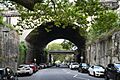
- Argyle Street: Argyle Cut
- 12–20 Argyle Street: Argyle Stores
- 39–43 Argyle Street: British Seamen's Hotel
- 45–47 Argyle Street: Gannon House
- 1–7 Atherden Street: Playfair's Terrace
- 2–4 Atherden Street: Avery Terrace
- Circular Quay Concourse, Circular Quay East and West: Sydney Cove railings
- 7–27 Circular Quay West: Campbell's Stores
- Cumberland Place: Cumberland Place and Steps
- Cumberland Street: Argyle Bridge
- 96–98 Cumberland Street: Glenmore Hotel
- 100–104 Cumberland Street: Australian Hotel
- 106–128 Cumberland Street: Cumberland Street Archaeological Site
- 130, 132–134, 136–138 and 140–142 Cumberland Street: Long's Lane Precinct
- 176 Cumberland Street: Lilyvale
- 178–180 Cumberland Street: Butchery Building
- 182 Cumberland Street: 182 Cumberland Street
- 182.5–188 Cumberland Street: 182.5–188 Cumberland Street
- 212–218 Cumberland Street: Lawson House
- 10–14 Essex Street: Harts Buildings
- 25–27 George Street: Mercantile Hotel
- 29–31 George Street: 29–31 George Street
- 33–41 George Street: Sergeant Major's Row
- 36–64 George Street: Old Mining Museum Building
- 43–45 George Street: Merchant's House
- 47 George Street: Union Bond Store
- 53–65 George Street: Harrington's Buildings
- 68–84 George Street: Metcalfe Bond Stores
- 69 George Street: Observer Hotel
- 73 George Street: Old Ambulance Station
- 75–75.5 George Street: Samson's Cottage
- 77–85 George Street: Unwin's Stores
- 86–88 George Street: Old Bushells Factory
- 87–89 George Street: Orient Hotel
- 91 George Street: ASN Hotel Building
- 93 George Street: 93 George Street, The Rocks
- 95–99 George Street: 95–99 George Street
- 98–100 George Street: Mariners' Church
- 101 George Street: 101 George Street
- 102–104 George Street: Old Coroner's Court
- 103 George Street: 103 George Street
- 105 George Street: 105 George Street
- 106–108 George Street: Sydney Sailors' Home
- 107–109 George Street: 107–109 George Street
- 110 George Street: Cadman's Cottage
- 111–115 George Street: Captain Tench Arcade
- 112–156 George Street: Sydney Cove West Archaeological Precinct
- 117–119 George Street: Julian Ashton Art School
- 121 George Street: 121 George Street
- 123–125 George Street: 123–125 George Street
- 127–129 George Street: Old Police Station
- 131–135 George Street: English, Scottish and Australian Bank
- 137 George Street: Fortune of War Hotel
- 139–141 George Street: 139–141 George Street
- 143–143a George Street: Russell Hotel
- 145 George Street: 145 George Street
- 147 George Street: 147 George Street
- 149–151 George Street: 149–151 George Street
- 153–155 George Street: New York Hotel
- 229 George Street: Brooklyn Hotel
- 231 George Street: 231 George Street
- 233–235 George Street: Johnson's Building
- 26–30 Gloucester Street: View Terrace facades
- 32–36 Gloucester Street: 32–36 and 38–40 Gloucester Street facades
- 46–56 Gloucester Street: 46–56 Gloucester Street
- 58–64 Gloucester Street: Susannah Place
- 66–68, 70–72 Gloucester Street: Baker's Terrace
- 103–111 Gloucester Street: Jobbins Terrace
- 113–115 Gloucester Street: 113–115 Gloucester Street
- 117–117a Gloucester Street: 117–117a Gloucester Street
- 120 Gloucester Street: Model Factory and Dwelling
- 157–169 Gloucester Street and Essex Street: Science House
- 16–18 Grosvenor Street: NSW Housing Board Building, Grosvenor Street
- 24–30 Grosvenor Street: Federation Hall
- 32–34 Grosvenor Street: Royal Naval House
- 28–30 Harrington Street: Reynolds' Cottages
- 32 Harrington Street: 32 Harrington Street
- 34–40 Harrington Street: Evans' Stores
- 42–52 Harrington Street: 42–52 Harrington Street
- 55–59 Harrington Street: 55–59 Harrington Street
- 61–65 Harrington Street: 61–65 Harrington Street
- 67 Harrington Street: 67 Harrington Street
- 71 Harrington Street: 71 Harrington Street
- 117–119 Harrington Street: Accountants House
- 121–127 Harrington Street: Bushells Building
- Hickson Road: Dawes Point Battery remains
- 1–5 Hickson Road: ASN Co building
- 4–6 Kendall Lane: Raphael Mackeller Stores
- 8 Kendall Lane: Samson's Cottage wall remains
- 13–15 Playfair Street: Argyle Terrace
- 17–31 Playfair Street: Playfair Street Terraces
- 22–26 Playfair Street: Penrhyn House
- 33 Playfair Street: Cleland Bond Store
Who Lives in The Rocks?

In 2021, about 629 people lived in The Rocks. Almost half of them (46.4%) were born in Australia. Most people (65.6%) spoke only English at home.
In 2016, there were 774 people living there. About 39.8% were born in Australia, and 51.1% spoke only English at home.
Fun Things to Do in The Rocks

The Rocks is very popular with tourists. It's close to Circular Quay and has amazing views of the famous Sydney Harbour Bridge. Plus, many of its buildings are very old and full of history.
You can find lots of shops selling souvenirs and crafts. There are also many old-fashioned pubs. Every weekend, The Rocks Market opens with about 100 stalls. During the week, you can visit art galleries, Australian clothing stores, and opal shops.
You can also take historic walks to see places like Cadmans Cottage, Sydney Observatory, and the Dawes Point Battery. This battery was the first strong defence point in New South Wales.
Near The Rocks, you'll find a boat terminal and the Museum of Contemporary Art. You can easily get to The Rocks by train, as it's a short walk from Circular Quay station.
Every year, Australian Water Polo holds an event called "Water Polo by the Sea" here. The Australia men's national water polo team plays against the International All Stars.
The Susannah Place Museum is a special historic house in The Rocks. It's a group of four old terrace houses built in 1844. People lived in them until 1990. The museum shows what life was like for working-class families in The Rocks over 150 years.
The Rocks in Stories
The Rocks, as it was in 1873, is the setting for parts of the novel Playing Beatie Bow.
Images for kids
-
Christmas night panoramic view at Campbell's Cove
-
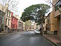
Harrington Street
-
Arts Exchange building from Hickson Street
-
Terrace Houses, Lower Fort Street
-
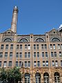
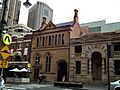
Observer Hotel
-
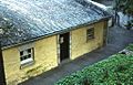
The rear of Cadmans Cottage
-
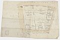
Essex and Harrington Street subdivision plan
-
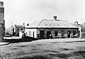
Princes Street, showing the first hotel on The Rocks
-
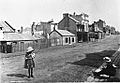
Princes Street, looking south
-
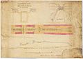
A transverse section showing the bridges over the Argyle Cut, 1832
-
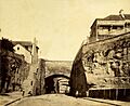
Argyle Cut, pictured in the 1870s
-
The Argyle Cut, constructed with convict labour
-
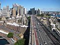
Southern approach of the Sydney Harbour Bridge with The Rocks to the left
-
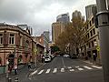
Argyle Street
-
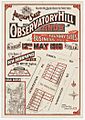
Observatory Hill, lands auction, 1910
-
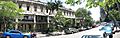
Terrace houses in The Rocks
-
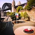
Sydney Harbour Bridge from The Rocks. The bridge is visible from most areas of the district.
-
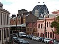
The former ES&A Bank branch building (middle) and Old Police Station (right)


,_The_Rocks,_Observer_Hotel_--_2019_--_3568.jpg)


.jpg)


.jpg)
.jpg)
More to Read
- Ambrose Pratt: King of the Rocks, a novel from 1900.
- D. Manning Richards. Destiny in Sydney: An epic novel of convicts, Aborigines, and Chinese embroiled in the birth of Sydney, Australia. This is the first book in the Sydney series.
- Grace Karskens, The Rocks: Life in Early Sydney, a book from 1997.
