Argyle Cut facts for kids
Quick facts for kids Argyle Cut |
|
|---|---|

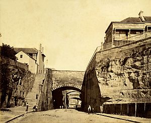
An c. 1870s albumen photoprint of the Argyle Cut, looking west.
|
|
| Location | Argyle Street, The Rocks, City of Sydney, New South Wales, Australia |
| Built | 1843–1868 |
| Owner | Sydney Harbour Foreshore Authority |
| Official name: Argyle Cut | |
| Type | state heritage (built) |
| Designated | 10 May 2002 |
| Reference no. | 1523 |
| Type | Road Embankment/Cutting |
| Category | Transport - Land |
| Builders | Convict and paid labour |
| Lua error in Module:Location_map at line 420: attempt to index field 'wikibase' (a nil value). | |
The Argyle Cut is a special roadway and a deep cut through rock in The Rocks, a suburb in Sydney, Australia. It's located on Argyle Street. This important historical site was built between 1843 and 1868. The work was done by both convicts and paid workers. Today, the Sydney Harbour Foreshore Authority owns it. The Argyle Cut was added to the New South Wales State Heritage Register on 10 May 2002, meaning it's a protected historical place.
Contents
History of the Argyle Cut
People wanted a direct path between The Rocks and Millers Point a long time ago. As early as 1803, newspapers talked about needing a shortcut through the rocky area. Before the cut, vehicles had to take a very long route to get from Sydney Cove to Darling Harbour. For people walking, there were only steep, rough paths and stairs.
Why the Cut Was Needed
As Darling Harbour grew, it became super important to connect it with Sydney Cove. The first ideas for the cut came from private businesses. A rich landowner named Alexander Berry had a big plan. He wanted to cut a deep channel through the middle of The Rocks. His idea was that shareholders would charge a fee (toll) for anyone using the cut.
However, Governor Bourke and the New South Wales Legislative Council said no to this private plan. The Government decided to do the work itself.
Building the Cut
A plan for the Argyle Cut was drawn up in 1832 by the New South Wales Government Architect, Edward Hallen. The plan showed how the road would slope and where bridges would go over it.
Work on the Argyle Cut started in 1843. It was done by convicts working in chain gangs. The work was very difficult with the tools they had. Also, many people in Sydney didn't like seeing convicts working in chains. So, the Government stopped the project when it was only half finished.
The cut was finally completed in 1859 by the Sydney Municipal Council. They used explosives and their own workers. The rock and dirt removed from the cut were used to fill in the mouth of the Tank Stream. They also used it to strengthen the sea wall at Circular Quay.
Changes Over Time
After the cut was finished, bridges were built over it. A bridge for Gloucester Street was built in 1862. Another for Cumberland Street followed in 1864. The Princes Street bridge was built in 1867-68. This last bridge was later taken down when the Sydney Harbour Bridge was built. An old stone from the Princes Street bridge, with the name of Mayor Charles Moore, is now on the south wall of the cut.
Later, around 1911-12, the Sydney Harbour Trust made more improvements. They changed Gloucester and Cumberland Streets. The two old bridges were replaced by one single bridge at Cumberland Street. The Argyle Stairs were also built at this time.
In the 1920s, as part of building the Bradfield Highway, the Princes Street bridge was removed. The Argyle Cut was made wider at that end. A much larger bridge for the Bradfield Highway was built overhead, finished in 1932.
What the Argyle Cut Looks Like
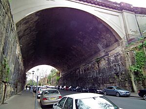
The Argyle Cut is a deep path cut into the rock. It connects Millers Point and The Rocks directly. Two bridges cross over it today. One is the Cumberland Street bridge, built around 1911. The other is the Bradfield Highway bridge, built around 1930. On the wall of the Argyle Cut, you can see an old message. It talks about the overhead bridges being finished in 1867-1868 by the Sydney Municipal Council, with Charles Moore as mayor.
How It Was Changed
The Argyle Cut started in 1843 and was finished in 1859.
- Old bridges for Gloucester, Cumberland, and Princes Streets were built between 1862 and 1868.
- Around 1911-12, Gloucester and Cumberland Streets were changed. The two bridges were replaced by one at Cumberland Street. The Argyle Stairs were also built then.
- In the 1920s, the Princes Street bridge was taken down. The cut was made wider for the Bradfield Highway, which was built over it.
Why the Argyle Cut is Important
The Argyle Cut is very important to the history and science of New South Wales. It also adds to the special character of The Rocks area.
Historical Importance
The Argyle Cut shows how Sydney's workforce changed over time. It was first built by convicts, then by paid council workers. This shows how the Sydney Council started taking responsibility for city growth and public projects. It was an early main road through The Rocks. It's also a great example of public works done by convicts. The changes it went through, like new bridges and widening, show how transport and city services improved over time. This includes work by the Sydney Harbour Trust and for the Sydney Harbour Bridge.
Design and Appearance
The deep cut creates a dramatic and interesting look on Argyle Street. It's considered one of the most impressive engineering achievements in early Sydney. It's often compared to Busby's Bore (an old water tunnel) and the building of Circular Quay.
Community Value
The Argyle Cut is a key part of The Rocks area. It helps give The Rocks its unique feel. Many people and groups, like the National Trust, see it as very important. This shows it's valued by the wider community. It has been a part of Sydney's society for over 150 years.
Learning from the Past
The Argyle Cut can help us learn about early Sydney's city planning and how streets and urban areas developed. It also shows how transportation systems grew in the city. It's a rare example of how early settlers dealt with tough geography. The big rock ridge that split the area made it hard to travel between two important port areas. The Argyle Cut solved this problem.
 | William Lucy |
 | Charles Hayes |
 | Cleveland Robinson |


