Cumberland Place and Steps facts for kids
Quick facts for kids Cumberland Place and Steps |
|
|---|---|

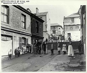
Cumberland Place and Steps, 1901
|
|
| Location | Cumberland Place, The Rocks, City of Sydney, New South Wales, Australia |
| Built | 1807 |
| Owner | Property NSW |
| Official name: Cumberland Place and Steps; Suffolk Lane; Stubbs Lane; Gloucester Lane; Cribb's Lane | |
| Type | State heritage (built) |
| Designated | 10 May 2002 |
| Reference no. | 1542 |
| Type | Townscape |
| Category | Urban Area |
| Lua error in Module:Location_map at line 420: attempt to index field 'wikibase' (a nil value). | |
The Cumberland Place and Steps are a special heritage-listed laneway and set of steps. They are located in The Rocks, a historic part of Sydney, New South Wales, Australia. This area was first built around 1807.
The laneway and steps are also known by other names like Suffolk Lane, Stubbs Lane, Gloucester Lane, and Cribb's Lane. The government agency Property NSW owns this historic site. It was added to the New South Wales State Heritage Register on May 10, 2002.
The steps at the top of Cumberland Place lead to Cumberland Street. At the bottom, another set of steps takes you to Harrington Street. Cumberland Place also provides access to the back of Susannah Place. This is a heritage-listed building that used to be cottages and a store. Today, it is a museum.
Contents
A Walk Through Time: History of Cumberland Place
Early Days: From Footpath to Cribbs Lane
Archaeologists found that a laneway called Cribbs Lane existed by at least 1811. It ran between Cumberland and Gloucester Streets. However, it might have been there even earlier. Old maps from 1807 show a path in this exact spot. A butcher named George Cribb bought a house along this path in 1809. By 1811, he owned a lot of land around the laneway.
By 1823, the section of the laneway between Cambridge Street and Cumberland Street was definitely known as Cribb's Lane. Some maps from that time even showed it, though one map from 1823 briefly called it 'Stubb's Lane'.
Growing Sydney and Changing Maps
In the 1820s, other similar laneways like Longs Lane were well-known. Susannah Place, a row of four terrace houses, was built in 1844. It stands on one side of Cumberland Place. This suggests the laneway's path was already set by the early 1820s.
The first official map showing a path in this location was in 1832. An 1838 plan of Sydney is the earliest official map to name it "Cribbs Lane."
In the 1840s, Sydney's main jail moved. A plan from 1848 showed a "Proposed Lane" where Cumberland Place is now. This means the laneway was already there, but this plan made it official.
As Sydney grew, maps became less detailed. Small laneways were often left out. However, the 1865 Trigonometrical Survey of Sydney clearly shows and labels Cribbs Lane. It ran all the way from Harrington Street to Cumberland Street. Interestingly, this map did not show any steps on the laneway itself. This might mean the steps we see today were built after 1865.
From Cribbs Lane to Cumberland Place
Between 1890 and 1900, the name of the laneway changed. For almost a century, it was known as Cribbs Lane. But in 1896, people asked the Sydney City Council to change the name to Cumberland Place. This new name sounded more important. The Council agreed, and all maps and photos after that time call it Cumberland Place.
The Steps Take Shape
The exact date the first steps were built is not certain. But they appeared sometime before 1887. The earliest documents showing the steps are from that year.
In 1907, the road levels on Harrington Street changed. This might have affected the steps leading into the laneway. An old picture from around 1911 shows the steps from Harrington Street were narrower than they are today. They were later widened, especially in the 1970s. Because they became very worn, the older side of the steps was fenced off in the 1990s. The other side was covered with concrete for safety.
In 1911, Cumberland Street was widened. This changed Gloucester Street a lot. A retaining wall was built in front of buildings like Susannah Place. This was to support the new, higher ground level of Gloucester Street. Around this time, a fourth set of stairs was added to Cumberland Place.
What Cumberland Place Looks Like Today
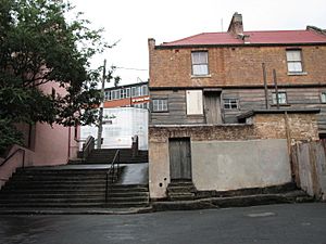
Cumberland Place and Steps is a public path that connects Harrington Street to Cumberland Street. It has a laneway with several sets of steps and flat areas called landings.
The Steps and Features
The first set of steps from Harrington Street is partly fenced off. This is because the stone is very old, worn, and uneven. These are the steps seen in the 1911 picture. They are narrower than the steps today. The steps were widened later and now have a concrete surface over the original stone.
After these steps, there is a landing area shaded by a tree. Then, concrete steps continue up to Cambridge Street. Here, you can see a very old lamp post from the 1840s.
The path keeps going up to Cumberland Street. There are two more sets of stairs with a landing. This leads to Cumberland Street, between Susannah Place (No. 64) and Baker's Terrace (Nos. 66-72). On the northern side of the first steps from Cambridge Street, you can see a bitumen block edging. These blocks are quite rare. They are only found in a few other places in Sydney, like Victoria Barracks.
The Hidden Cribbs Lane
Across the road, the original Cribbs Lane section was uncovered in 1994. This happened during an archaeological dig. It is believed that this part of Cribbs Lane was once connected to Cumberland Place. It likely extended all the way from Cumberland Street to Harrington Street. There were plans to reopen this section of Cribbs Lane to the public around 2009.
Condition of the Site
As of 2004, the site was in fair condition. The very worn steps have been fenced off for safety. A layer of concrete has been added over the original stone. This helps with safety and protects the old steps. The Cribbs Lane section, between Gloucester and Cumberland Street, is made of sandstone. It was covered by bitumen. This area is very important for archaeology. The Cumberland Place section, between Gloucester and Harrington Street, also likely holds important archaeological finds.
Why Cumberland Place is Important
Cumberland Place is very important to the history of New South Wales. It is one of the oldest known pedestrian paths in The Rocks, and possibly in Australia. People have used it continuously since at least 1808.
It shows how Sydney looked in its early days, especially in the 1800s. The way it was built, with ramps, stairs, and landings, shows how early settlers dealt with the rocky landscape. There is a good chance that very old archaeological items are still buried here. These items could tell us more about Sydney's past.
The steps, stair risers, and retaining walls are special features. The old stone risers, worn down by many years of use, are especially interesting to archaeologists.
Cumberland Place is important because:
- It shows the history of pedestrian paths in Sydney. It has been used since at least 1808.
- It shows how the early colony planned its streets around the rocky land.
- It has the potential to reveal important archaeological information about the past.
- It is rare in Sydney as a surviving example of an early urban path. Its old stone features are also rare.
- It helps us understand what an early urban environment in Sydney was like.
 | Kyle Baker |
 | Joseph Yoakum |
 | Laura Wheeler Waring |
 | Henry Ossawa Tanner |


