
Barangaroo, New South Wales facts for kids
Quick facts for kids BarangarooSydney, New South Wales |
|||||||||||||||
|---|---|---|---|---|---|---|---|---|---|---|---|---|---|---|---|
.jpg)
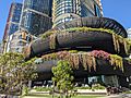
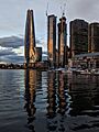
Barangaroo waterfront
|
|||||||||||||||
| Established | 1788 as Cockle Bay Point; 1820s as Millers Point; 2007 as Barangaroo |
||||||||||||||
| Postcode(s) | 2000 | ||||||||||||||
| Area | 0.22 km2 (0.1 sq mi) | ||||||||||||||
| Location | 1 km (1 mi) north-west of Sydney CBD | ||||||||||||||
| LGA(s) | City of Sydney | ||||||||||||||
| County | Cumberland | ||||||||||||||
| Parish | St. Philip | ||||||||||||||
| State electorate(s) | Sydney | ||||||||||||||
| Federal Division(s) | Sydney | ||||||||||||||
|
|||||||||||||||
Barangaroo is a modern area in central Sydney, Australia. It is located on the north-western side of the Sydney central business district (CBD). This area is also near the southern end of the Sydney Harbour Bridge. It is part of the City of Sydney local government area.
Long ago, Indigenous Australians used this land for fishing and hunting. Later, it became a busy docklands area. During the Great Depression, workers called it "The Hungry Mile." This was because many people walked from wharf to wharf, hoping to find a job.
In 2003, the New South Wales Government decided to change Barangaroo. They wanted to turn the old shipping area into new offices and fun places. The big project started in 2012. It includes new parks, apartment buildings, a metro station, a hotel, and cultural spaces.
History of Barangaroo
Early Days and Indigenous Culture
This area was very important to the Wallangang Aboriginal Cadigal people. They used it for hunting and fishing for thousands of years. Old shell piles and rock carvings show that people lived here about 6,000 years ago. Other evidence suggests people lived in the wider Sydney area for at least 14,500 years.
In 2007, the East Darling Harbour area was renamed Barangaroo. This name honors Barangaroo, a strong Kamaraygal woman. She was the second wife of Bennelong, an important Aboriginal leader. Barangaroo did not always agree with Bennelong working with the British colonists. A marine from the First Fleet, Watkin Tench, wrote about her. He described how she showed her anger when Bennelong left with the colonists. She even broke his fishing spear!
For about 200 years, the suburb now called Barangaroo was known as Millers Point. The northern tip was briefly called Barangaroo Point. However, the Geographical Names Board changed it back to Millers Point. This was because the name Millers Point was historic.
European Settlement and Growth
When Europeans first arrived in 1788, there were about 1500 Aboriginal people living in the Sydney area. Sadly, many died from smallpox soon after. The area was first called Cockle Bay Point. Not much happened there in the early years.
In the 1820s, windmills were built on what became Millers Point. European settlers started building houses and a small village. By the 1830s, the first wharf was built. This brought more people to the area. In 1843, the Australian Gas Light Company opened a gas works. This led to more homes and dockland development. More ships came to the harbor to deliver coal for the gas works.
In 1859, a direct path called the Argyle Cut was made. It connected The Rocks to Millers Point. This made travel safer and faster. It also helped the area grow even more.
Shipping Era and Changes
From the 1850s to the 1880s, the docks in East Darling Harbour grew a lot. It became a busy place for commercial shipping. During the gold rush, many workers left for the gold fields. Companies had to offer better pay to keep workers in Sydney. By the 1870s, the waterfront was full of warehouses. They mostly stored wool, a valuable export.
Between 1880 and 1900, the area changed. Shipyards closed, and bigger wharves were built for larger ships. This meant fewer skilled shipbuilders were needed. More unskilled workers were hired to load and unload ships. This changed the community into a working-class neighborhood.
In 1900, the bubonic plague arrived in Sydney. This caused alarm on the docks. Many houses were taken over to reshape The Rocks and Millers Point. Shipping stopped while the area was cleaned. The Sydney Harbour Trust took over the port. They built new, larger wharves that could handle modern ships. By the 1930s, these new wharves stretched from Millers Point to Darling Harbour.
The Great Depression gave the dock areas a sad nickname: The Hungry Mile. Many workers would line up along the wharves, hoping for a job. Only the strongest or most willing workers were chosen. This was a very tough time for the community.
Modern Shipping and Redevelopment
By the 1950s, ships became too large for the old wharves. Shipping containers also changed how goods were moved. One crane could now do the work of many people. The southern part of Barangaroo became a huge concrete area. But the port had problems. It lacked good rail or road links for cargo. As container ships grew, these problems got worse.
Eventually, commercial shipping moved away from Sydney Harbour. New ports like Port Botany were built in 1979. These new ports had better connections and could handle larger ships. This made Port Botany the main port for Sydney.
In 2003, the New South Wales Government decided to redevelop the Barangaroo site. It would become parklands and commercial spaces. An international design competition was held in 2005. The winning design was announced in 2006. The area was officially renamed Barangaroo in October 2006. The shipping companies moved their operations to Port Botany. This ended nearly 130 years of cargo shipping in eastern Darling Harbour.
Before the big redevelopment, Barangaroo was used for large events. It hosted part of World Youth Day 2008. A temporary passenger terminal for cruise liners was also located here.
Barangaroo's Redevelopment
Planning the New Barangaroo
The Barangaroo Delivery Authority was created to manage the project. Its goal was to create a high-quality area with offices, homes, and public spaces. This included building a new headland park. A special panel helped guide the design.
There was some debate about the size of the new buildings. Some people worried they would be too tall or cast long shadows. In 2007, a concept plan was released. In 2009, the government decided to add more office space to help the project financially.
Later, a new design was chosen. It included a very tall hotel planned to be built over the water. This caused public concern. Community groups formed, calling the area "the Greedy Mile." They worried about the changes to the original plans.
In 2011, a new government reviewed the project. They asked the developers to move the hotel off the harbor. Discussions about the design continued.
Barangaroo's Three Main Areas
The redevelopment project is divided into three main parts: Barangaroo South, Barangaroo Central, and Barangaroo Reserve.
Barangaroo South: Business and Homes

-
Barangaroo House
-
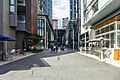
Mercantile Walk
-
Wulugul Walk
-
Watermans Cove


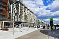
Barangaroo South is the southern part of the site. It is like an extension of Sydney's CBD. It has tall office buildings, apartments, shops, and public areas. Three large skyscrapers, called International Towers Sydney, are at its heart. The tallest one is 217 meters (712 feet) high. These towers also have shops on their lower levels.
Barangaroo Central: Future Developments
Barangaroo Central will have smaller residential and commercial buildings. In 2012, a company proposed building a large hotel, casino, and entertainment complex here. This idea caused a lot of discussion. Some people worried about its location and impact.
After much debate, the government decided to negotiate with the company. In 2013, the proposal moved to its final stage. In November 2013, the casino and hotel project, called Crown Sydney, was approved for Barangaroo. Crown Sydney opened its hotel and restaurants in December 2020. The casino part is still awaiting final approval.
Barangaroo Reserve: A New Headland Park
.jpg)

Barangaroo Reserve is a 6-hectare (15-acre) park at the northern end of Barangaroo. It opened in 2015. The park looks like a natural headland, similar to how the shoreline was before 1836. Back then, the original headland was cut away to make space for wharves. The new park brings back the natural look of Sydney Harbour.
The park has grassy areas, lookouts, and paths for walking and cycling. It also has two new harbor coves and rock pools. These features are made from sandstone dug up right from the Barangaroo site. Over 10,000 sandstone blocks were used to build the foreshore. Many native trees, plants, and shrubs were planted. These plants were chosen from species native to Sydney Harbour.
Underneath the park, there is a cultural facility called "the Cutaway" and a car park. The Sydney Harbour Control Tower, built in 1974, was once part of this area. It was removed to fit the natural design of the reserve.
Population
In 2016, 189 people lived in Barangaroo. It was known as Sydney's most expensive area for homes. By the 2021 census, the population had grown to 220 people. Some people have criticized that the area, once planned for affordable housing, now has very expensive homes.
Transport
Ferry

The Barangaroo ferry wharf opened in June 2017. It replaced the old Darling Harbour ferry wharf. This complex is the main ferry hub for the western city center. It has two wharves, with space for a third later. Sydney Ferries' F3 Parramatta River and F4 Pyrmont Bay services use this wharf.
Metro

Barangaroo railway station is a new rapid transit station. It opened on August 19, 2024. It is part of the Sydney Metro City & Southwest project. The station uses automated six-car trains. These trains run very often, sometimes every two minutes during busy times.
Bus
Barangaroo is also served by Transdev John Holland bus routes. These routes connect Barangaroo to the Eastern Suburbs of Sydney.
Wynyard Walk
Wynyard Walk is a special pathway that connects Wynyard station to Barangaroo. It opened in 2016. This walk makes it easy for people to get from the train station to Barangaroo.
Images for kids
-
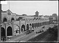
Wharves on Hickson Road circa 1920
-
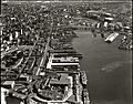
Aerial view of the wharves in 1937
-
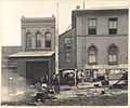
A laneway at the side of Sussex Street during the bubonic plague outbreak in Sydney, 1900.
-
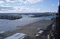
The undeveloped area in 2009
-
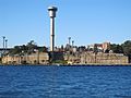
A campaign to save the Sydney Harbour Control Tower for its maritime heritage ultimate failed with the redevelopment of Barangaroo Reserve
-
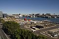
Initial site works in May 2012
-
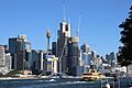
View of Barangaroo South from Balmain East in December 2014
-
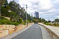
Wulugul Walk
-
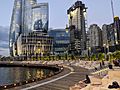
The Barangaroo skyline from Pyrmont, 2023

.jpg)
.jpg)


.jpg)


