
Rosebery, New South Wales facts for kids
Quick facts for kids RoseberySydney, New South Wales |
|||||||||||||||
|---|---|---|---|---|---|---|---|---|---|---|---|---|---|---|---|

Rosebery Hotel
|
|||||||||||||||
| • Density | 3,909.5/km2 (10,126/sq mi) | ||||||||||||||
| Established | 1894 | ||||||||||||||
| Postcode(s) | 2018 | ||||||||||||||
| Elevation | 26 m (85 ft) | ||||||||||||||
| Area | 1.9 km2 (0.7 sq mi) | ||||||||||||||
| Location | 6 km (4 mi) south of Sydney CBD | ||||||||||||||
| LGA(s) |
|
||||||||||||||
| State electorate(s) | Heffron | ||||||||||||||
| Federal Division(s) | |||||||||||||||
|
|||||||||||||||
Rosebery is a suburb located in the southern part of Sydney, New South Wales, Australia. It is about 6 kilometres south of the main city centre, known as the Sydney central business district. Rosebery is managed by two local councils: the City of Sydney and the Bayside Council.
Contents
A Look Back: Rosebery's History
Rosebery got its name from Archibald Primrose, 5th Earl of Rosebery. He was the Prime Minister of the United Kingdom for a short time in 1894–95. The suburb was named in his honour after he visited Australia in 1883–84.
From Racecourse to Homes
Rosebery was once home to the Rosebery Racecourse. This track first opened in 1906 for pony races. Horse races held here became very popular, especially in the 1920s. During World War II, the race track was used as an army camp. After the war, it became a training track for horses.
In 1961, much of the land was bought and turned into an area for factories and businesses. The government also bought some land to build public housing. The northern part of Rosebery was planned to be a 'garden suburb'. This means it was designed with lots of green spaces and gardens. People even used to have garden competitions here! Most houses in Rosebery are single-storey homes, like the California bungalow or Federation Bungalow styles.
Trams in Rosebery
Did you know Rosebery once had its own tram line? It opened in 1902 and helped people travel around. The line was extended in 1924. However, the tram line was closed down in 1957.
Who Lives in Rosebery?
According to the 2021 census, about 13,533 people live in Rosebery. Many different cultures make up the community. The most common backgrounds are Chinese, English, Australian, Irish, and Greek.
About 43.8% of people in Rosebery were born in Australia. Other common birthplaces include China, England, Greece, Ireland, and Indonesia. While many people speak English at home, other languages like Mandarin, Greek, Cantonese, Spanish, and Indonesian are also spoken.
Shopping and Businesses
Rosebery has a small shopping centre located on Gardeners Road. You can also find many businesses and factories along Botany Road and in nearby areas.
Schools in the Area
For younger students, Gardeners Road Primary School is the local public school. It's located where Gardeners Road and Botany Road meet. There's also St Joseph's Catholic primary school on Rosebery Avenue. If you're interested in movies, the Sydney International Film School is also on Rosebery Avenue.
Parks and Green Spaces
Rosebery has several parks where you can relax and play. The largest one is Turruwul Park, which is a great spot for sports. It's home to the Redfern Raiders Soccer Club. There's also Crete Reserve, a smaller park at the end of Rosebery Avenue. Other small parks can be found at Lever Street and at the corner of Harris and Coward Streets. There is also a park in Kimberley Grove.
Images for kids
-
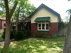
A typical Federation Bungalow house on Gardeners Road.
-

A California bungalow house on Tweedmouth Avenue.
-
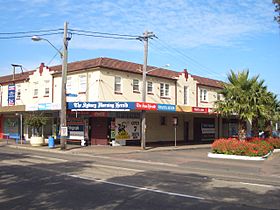
A shopping area on Gardeners Road.


