Southern Sydney facts for kids
Quick facts for kids Southern SydneyNew South Wales |
|
|---|---|

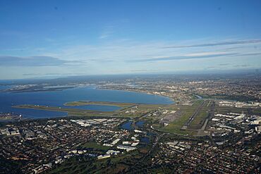
Sydney Airport, Botany Bay and surrounding suburbs
|
|
| LGA(s) |
|
| State electorate(s) | Cronulla, Heathcote, Heffron, Kogarah, Miranda, Oatley, Rockdale |
| Federal Division(s) | Banks, Barton, Cook, Hughes, Sydney, Kingsford Smith |
Southern Sydney is a large area that makes up the southern part of Greater Sydney in New South Wales, Australia. It stretches from just south of the main city center (the Sydney CBD) all the way down to the Sutherland Shire.
This region includes many suburbs within different local government areas. These are like local councils that manage services for the community. The main ones are Georges River Council, the Sutherland Shire, most of Bayside Council, and the southern parts of the City of Sydney.
Because large bodies of water like Botany Bay and the Georges River separate some areas, sometimes suburbs on the eastern side of Botany Bay are also considered part of Southern Sydney. Many of the local councils in Southern Sydney work together in a group called the Southern Sydney Regional Organisation of Councils (SSROC).
The southern suburbs of Sydney can be divided into three main areas:
Contents
Exploring Southern Sydney's Regions
The Inner South
The Inner Southern Suburbs are sometimes called 'South Sydney'. They include the suburbs directly south of Central Station in the City of Sydney, and some parts of Bayside Council. This area goes down to Sydney Airport.
The Inner South is located west of a major road called the Eastern Distributor. It is also east of the Alexandra Canal and the T3 Train Line. Some of the suburbs here include Redfern, Waterloo, Zetland, Alexandria, and Mascot.
This area has several train stations: Redfern, Green Square, and Mascot. There is also a Metro station at Waterloo. Green Square is a specific spot where several suburbs meet. Green Square and Mascot stations are on the Airport Link, which is part of the T8 train line.
Many of these suburbs used to be mainly for factories and businesses. Now, they have changed a lot and have many new apartment buildings where people live. The Inner Southern Suburbs are sometimes seen as part of the inner city or even the Eastern Suburbs. However, they are actually located directly south of the Sydney CBD.
The St George Area
The St George area is another important part of Southern Sydney. It includes all the suburbs in the Georges River Council and the western part of Bayside Council. This area used to be known as Rockdale City before 2016.
The St George area is bordered by Salt Pan Creek to the west and the Georges River to the south. To the east is Botany Bay, and to the north are the M5 Motorway and Wolli Creek. The name 'St George' comes from an old land division called the Parish of St George.
The southern part of this old parish, below the M5 and Wolli Creek, is what people usually mean when they talk about the St George Region as part of Southern Sydney today. The northern part of the Parish of St George is generally considered part of South-Western Sydney.
The Sutherland Shire
The Sutherland Shire is located south of Botany Bay and the Georges River. It is about 26 kilometers (16 miles) south of the Sydney central business district. The Shire shares its borders with the City of Canterbury-Bankstown and Georges River Council areas.
The main office for the Sutherland Shire local government is in the suburb of Sutherland.
Suburbs in Southern Sydney
Inner South Suburbs
- Alexandria
- Beaconsfield
- Eastlakes (West of Eastern Distributor)
- Eveleigh
- Mascot
- Redfern
- Rosebery
- Waterloo
- Zetland
A key spot in the inner south is:
St George Suburbs
- Allawah
- Arncliffe
- Banksia
- Bardwell Park
- Bardwell Valley
- Bexley
- Bexley North
- Beverley Park
- Beverly Hills
- Blakehurst
- Brighton-Le-Sands
- Carlton
- Carss Park
- Connells Point
- Dolls Point
- Hurstville
- Hurstville Grove
- Kingsgrove
- Kogarah
- Kogarah Bay
- Kyeemagh
- Kyle Bay
- Lugarno
- Monterey
- Mortdale
- Narwee
- Oatley
- Peakhurst
- Penshurst
- Ramsgate
- Ramsgate Beach
- Riverwood
- Rockdale
- Sandringham
- Sans Souci
- South Hurstville
- Turrella
- Wolli Creek
Sutherland Shire Suburbs
- Alfords Point
- Bangor
- Barden Ridge
- Bonnet Bay
- Bundeena
- Burraneer
- Caringbah
- Caringbah South
- Como
- Cronulla
- Dolans Bay
- Engadine
- Grays Point
- Greenhills Beach
- Gymea
- Gymea Bay
- Heathcote
- Illawong
- Jannali
- Kangaroo Point
- Kareela
- Kirrawee
- Kurnell
- Lilli Pilli
- Loftus
- Lucas Heights
- Maianbar
- Menai
- Miranda
- Oyster Bay
- Port Hacking
- Sandy Point
- Sutherland
- Sylvania
- Sylvania Waters
- Taren Point
- Waterfall
- Woolooware
- Woronora
- Woronora Heights
- Yarrawarrah
- Yowie Bay
Other places managed by the Sutherland Shire include:
- Audley
- Caravan Head
- Como West
- Elouera
- Garie Beach
- Gundamaian
- North Cronulla
- North Engadine
- Shelly Beach
- Sylvania Heights
- Wanda Beach
- Warumbul
 | Percy Lavon Julian |
 | Katherine Johnson |
 | George Washington Carver |
 | Annie Easley |

