
Ramsgate, New South Wales facts for kids
Quick facts for kids RamsgateSydney, New South Wales |
|||||||||||||||
|---|---|---|---|---|---|---|---|---|---|---|---|---|---|---|---|

Intersection Tavern, corner of Rocky Point Road and Ramsgate Road
|
|||||||||||||||
| Population | 1,114 (2016 census) | ||||||||||||||
| Postcode(s) | 2217 | ||||||||||||||
| Elevation | 17 m (56 ft) | ||||||||||||||
| Location | 16 km (10 mi) south of Sydney CBD | ||||||||||||||
| LGA(s) |
|
||||||||||||||
| State electorate(s) | Rockdale | ||||||||||||||
| Federal Division(s) | Cook | ||||||||||||||
|
|||||||||||||||
Ramsgate is a suburb located in southern Sydney, Australia. It is about 16 kilometers (10 miles) south of the main Sydney central business district. Ramsgate is part of the St George area.
The suburb is divided by a road called Rocky Point Road. The part of Ramsgate to the east of this road belongs to the Bayside Council. The part to the west of the road is in the Georges River Council area. Ramsgate Beach is a separate suburb located just to the east. Ramsgate is surrounded by other suburbs. These include Ramsgate Beach, Monterey, Kogarah, Beverley Park, and Sans Souci.
Contents
A Glimpse into Ramsgate's Past
The land between the Cooks River and Georges River was once known as Seven Mile Beach. This name was changed in 1874. It became Lady Robinson's Beach. This was to honor the wife of Governor Sir Hercules Robinson. Cook Park is named after Samuel Cook. He believed it should be a public park for everyone to enjoy.
Ramsgate got its name from a seaside town in England. There were plans to build a special model village here. However, this idea was later not carried out.
Scarborough Park was created in the 1830s. It was made from a swamp area. This swamp was sometimes called Pat Moore's Swamp. Patrick Moore was given about 60 acres (24 hectares) of land in 1812. The park was named by Thomas Holt. He named it after the English coastal town of Scarborough, Yorkshire. It was also named after the First Fleet convict ship, Scarborough. This ship briefly stopped in Botany Bay in 1788.
Shopping and Local Spots
Ramsgate is mostly a place where people live. But it also has a shopping area. This shopping strip is on Rocky Point Road. It is near the intersection with Ramsgate Road. Here you can find the post office and a pub called The Intersection.
Another shopping area is just over the border in Ramsgate Beach. This strip is on Ramsgate Road. It is close to The Grand Parade. You can find a supermarket there. The Ramsgate RSL Club is also located nearby. It is right on the border of the two suburbs.
Parks and Green Spaces
Ramsgate has several parks where you can relax and play.
- Scarborough Park
- Leo Smith Reserve
- Tonbridge St Reserve
- Rotary Park
Important Landmarks
Here are some well-known places in Ramsgate:
- Syd Frost Memorial Hall
- Ramsgate Primary School
- Ramsgate RSL
Who Lives in Ramsgate?
The 2021 Australian Census counted 1,151 people living in Ramsgate. Most residents, about 61.8%, were born in Australia. Other common birthplaces include Greece (4.1%), England (2.4%), China (2.2%), and Egypt (2.1%).
English is the main language spoken at home for 57.6% of residents. Other languages spoken include Greek (12.4%), Spanish (3.8%), Arabic (3.7%), and Mandarin (2.3%). When it comes to religion, the most common choices were Catholic (22.6%), No Religion (21.7%), Orthodox (19.9%), and Anglican (10.3%).
Images for kids
-
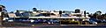
Ramsgate RSL
-
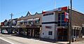
Rocky Point Road, Ramsgate
-
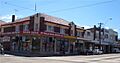
Rocky Point Road, Ramsgate
-
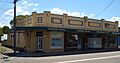
Rocky Point Road, Ramsgate


