
Lilli Pilli, New South Wales facts for kids
Quick facts for kids Lilli PilliSydney, New South Wales |
|||||||||||||||
|---|---|---|---|---|---|---|---|---|---|---|---|---|---|---|---|

Lilli Pilli Point
|
|||||||||||||||

Lilli Pilli
Location in Sydney
|
|||||||||||||||
| Population | 1,390 (2016 census) | ||||||||||||||
| • Density | 1,540/km2 (4,000/sq mi) | ||||||||||||||
| Postcode(s) | 2229 | ||||||||||||||
| Elevation | 35 m (115 ft) | ||||||||||||||
| Area | 0.9 km2 (0.3 sq mi) | ||||||||||||||
| Location | 26 km (16 mi) south of Sydney CBD | ||||||||||||||
| LGA(s) | Sutherland Shire | ||||||||||||||
| State electorate(s) | Cronulla | ||||||||||||||
| Federal Division(s) | Cook | ||||||||||||||
|
|||||||||||||||


Lilli Pilli is a lovely suburb located in southern Sydney, Australia. It is about 26 kilometers south of the main city center. This area is part of the Sutherland Shire, which is a local government area.
Contents
Discovering Lilli Pilli's Past
Lilli Pilli got its name from a special native plant called the 'lilly pilly'. This plant, a type of myrtle, used to grow a lot on the point. A long time ago, in the 1800s, a man named Thomas Holt owned most of the land here. This land stretched from Sutherland all the way to Cronulla.
In 1840, old maps showed that Francis Mitchell also owned some land on the point. The local public school first opened its doors in 1957. It celebrated its 50th birthday in 2007, which was a big event for the community!
Exploring Lilli Pilli's Location
Lilli Pilli is located right on the northern side of the Port Hacking estuary. An estuary is where a river meets the sea. The only suburbs next to Lilli Pilli are Caringbah South, Port Hacking, and Dolans Bay. Across the water, on the other side of Port Hacking, you can find the small villages of Maianbar and Bundeena.
Lilli Pilli is surrounded by several beautiful waterways. These include Gannons Bay, Little Turriel Bay, the Port Hacking River, and Great Turriel Bay. Lilli Pilli Point is a special spot at the very end of Lilli Pilli Point Road.
Lilli Pilli Point Bushland Reserve
The Lilli Pilli Point Bushland Reserve looks out over the Royal National Park. This reserve is a fantastic place for a quiet picnic. It's often protected from the wind, making it a comfortable spot. You can also find a rock ledge along the northern point. This area has many great fishing spots, stretching all the way to Little Turriell Bay.
Getting Around Lilli Pilli
If you need to travel around Lilli Pilli, you can use the bus service. U-Go Mobility operates bus route 977. This bus goes from Lilli Pilli Point to Caringbah and even to Westfield Miranda, a large shopping center.
Schools in the Area
Lilli Pilli has a great primary school for younger students.
- Lilli Pilli Primary School is located on Lilli Pilli Point Road.
- Lilli Pilli Kindergarten is also nearby in Caringbah. This school has achieved many sporting successes. For example, they won the PSSA Soccer Division One Cup in 2008!
Sports and Fun in Lilli Pilli
Lilli Pilli is a very active community with several sports and recreation options.
- The Lilli Pilli Football Club is based here. Their main home ground is Lilli Pilli Oval. However, they also use other fields like Caringbah Oval, Solander Fields, Captain Cook Oval, and Breen Park.
- Lilli Pilli is also home to the 1st Lilli Pilli Sea Scouts. This group offers fun and adventure for young people.
In 2019, Lilli Pilli Oval received some exciting upgrades. These improvements included a better playing surface and a renovated clubhouse.
Images for kids
-
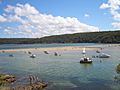
Port Hacking estuary at Lilli Pilli
-
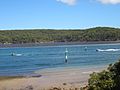
Port Hacking estuary at Lilli Pilli
-
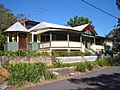
A house on Lilli Pilli Point


