
Oatley, New South Wales facts for kids
Quick facts for kids OatleySydney, New South Wales |
|||||||||||||||
|---|---|---|---|---|---|---|---|---|---|---|---|---|---|---|---|

Oatley Clock Tower, Frederick Street
|
|||||||||||||||
| Population | 10,486 (2016 census) | ||||||||||||||
| Established | 1883 | ||||||||||||||
| Postcode(s) | 2223 | ||||||||||||||
| Elevation | 48 m (157 ft) | ||||||||||||||
| Location | 18 km (11 mi) south of Sydney CBD | ||||||||||||||
| LGA(s) | Georges River Council | ||||||||||||||
| State electorate(s) | Oatley | ||||||||||||||
| Federal Division(s) | Banks | ||||||||||||||
|
|||||||||||||||


Oatley is a lovely suburb in Southern Sydney, New South Wales, Australia. It is about 18 kilometres (11 miles) south of the Sydney central business district (CBD). Oatley is part of the St George area and is governed by the Georges River Council.
The suburb sits on the northern side of the Georges River, which is a tidal estuary. Its shoreline includes parts of Oatley Bay, Lime Kiln Bay, and all of Neverfail Bay, Gungah Bay, and Jewfish Bay.
Contents
Oatley's Past
First People's History
The land where Oatley is today was originally home to the Dharug or coastal Eora people. Both groups spoke a similar language. The Tharawal people lived nearby, on the south side of the river. The Georges River Council recognizes the Biddegal/Bidjigal/Bedegal clan of the Eora as the first inhabitants of this land.
You can still find signs of Aboriginal life in Oatley. There are many shell middens (ancient piles of shells from meals) and rock shelters near the Georges River. Lime Kiln Bay once had even more shell middens, built up over hundreds of years by local people.
Early European Settlement
One of the first meetings between British settlers and Aboriginal people happened near Oatley. On January 20, 1788, Arthur Phillip and Philip Gidley King explored the 'South-West Arm of Botany Bay' (now Georges River). They landed near Lime Kiln Bay. Since they didn't find enough freshwater, the settlers moved to Port Jackson, where Sydney was founded six days later.
Lime Kiln Bay got its name because early settlers burned shells from the Aboriginal middens there. They did this to create lime, which was used for building. These kilns were located in what is now Oatley Park.
The suburb of Oatley is named after James Oatley Snr. He was a clockmaker who came to Australia as a convict in 1814. In 1821, Governor Lachlan Macquarie pardoned him and made him overseer of the Town Clock. This was because James had installed the clock at Hyde Park Barracks.
James Oatley Snr received land in the Oatley area in 1833, but he never lived there. He called his land Needwood Forest. His land stretched from Gungah Bay north to what became Hurstville Road. His son, Frederick Oatley, later sold the land in 1881 to Charles Cecil Griffiths. Charles and his brother, Frederick Griffiths, were buying land along the new railway line.
The Railway Arrives
The railway line through Oatley opened in December 1885, reaching Sutherland. It included a big bridge over the Georges River, connecting Oatley to Como. The first Oatley railway station opened in 1886. It's believed that building the station was a condition for Charles Griffiths to sell land for the railway.
The railway's arrival led to the first housing developments in the area. Many of Oatley's streets were planned during this time. Most streets east of the railway line are named after members of the Griffiths family from the Victorian era. There's also a Griffiths Street west of the railway line.
Before these developments, there was a small village near Neverfail Bay. It was mainly home to oyster farmers and was sometimes called 'Thompsonville'.
In 1898, Oatley was the scene of a chase involving police and George Peisley, a cattle and horse thief. He was hiding in a sandstone cave on Gungah Bay. Peisley escaped that day but was caught later.
In 1905, land near Neverfail Bay was set aside for military use, but nothing was built. In the same year, the railway line and station were moved to their current spot.
The post office opened in 1903, giving the area its official name, Oatley. Before this, the area west of the railway was part of Hurstville, and the east was part of Kogarah.
Oatley is famous for being the end point of Sydney's first railway electrification project. This project reached Oatley station from Sydney Central in 1926. The first electric train service left Oatley station on October 3, 1926, at 5:18 am.
Since 1942, the old Como railway bridge has been used for a main water pipeline from the Woronora Dam to Penshurst.
In January 1946, a shark attack happened in shallow water near Oatley Bay. Large sharks have been seen in the bay many times. Swimmers at Oatley Park and the Oatley Pleasure Grounds are now protected by shark-proof enclosures.
Oatley was once known for growing and eating Sydney Rock Oysters. In 1953, an Oatley man won an oyster-eating contest by eating 26 dozen oysters in 30 minutes!
The Oatley Bowling Club was formed in 1959. Its emblem was a clock, with the hands set at 10:15, the exact time of their first meeting. The club has since closed.
The Oatley campus of Alexander Mackie College of Advanced Education opened in 1981. It is now a secondary school, the Oatley Senior Campus of the Georges River College.
Before 2016, Oatley was split between the City of Hurstville (west of the railway) and the City of Kogarah (east of the railway).
Local Industries of the Past
Even though Oatley is mostly residential now, it used to have different industries.
Oyster Farming

For over 100 years, Sydney Rock Oysters were grown commercially along the Georges River at Oatley. Freshwater from the Woronora River helped create good conditions for fast-growing oysters. The Georges River also had the advantage of being the only oyster growing area close to Sydney, the biggest market.
Six families of oyster farmers worked from Neverfail Bay. This bay was a base for working oyster farms both upstream and downstream. There was also a smaller oyster farm at Jewfish Bay. You can still find old oyster shells and some remains of oyster farming equipment today.
Oysters were grown on racks or on artificial shell beds in the river. For many years, oysters were sent to market in hessian sacks (each holding about 100 dozen oysters) from Oatley railway station.
End of Oyster Farming
.jpg)
The oyster industry on the Georges River was at its busiest in the 1970s. However, it faced many challenges. These included pollution, invasive Pacific Oysters, and increasing city development.
After a major food poisoning event in 1978, linked to Georges River oysters, rules changed. Harvesting was stopped after heavy rain, water quality was checked often, and oysters were filtered. Despite these efforts, another food poisoning event in 1990 further damaged the river's oyster reputation.
.jpg)
In 1992, a disease called 'winter mortality' badly affected the oysters. Then, in the mid-1990s, a new disease called 'QX disease' appeared. This disease wiped out 90% of the farmed oysters in 1994. QX-resistant oysters came too late to save most of the Georges River industry.
Today, there are no oyster farms at or near Oatley.
Judd's Hurstville Brickworks
Judd's Hurstville Brickworks was a factory that made bricks. It was located on Hurstville Road, partly in Oatley and partly in Mortdale. It operated from 1884 to 1972. The factory used shale from a quarry on the site. The brickworks even had its own railway siding. Some brick cottages built for workers still stand on Judd Street.
Other Factories
In the past, other factories operated in Oatley. A factory owned by Albert Page made vehicle number plates from 1935 to the 1950s. Later, the Quill paper products factory was on the same site. Surelli Furniture Pty Ltd had a factory on Ada Street until the late 1980s. These factory sites are now homes. The Cuthbertson family also ran a small factory making children's shoes.
Local Environmental Efforts
Oatley has a long history of caring for its environment. Famous conservationists, Myles and Milo Dunphy, lived here. The Oatley Flora and Fauna Conservation Society (OFF) was founded in 1955 and is still active today.
In the past, land in Oatley Bay and Lime Kiln Bay was being filled in, and Lime Kiln Bay was even used as a rubbish tip. OFF successfully campaigned to stop this. They worked with local oyster farmers, who were worried about pollution affecting the river, and other conservation groups to protect the area.
Places to Visit
Shopping Areas
Oatley has a main shopping area on Oatley Avenue and Frederick Street, close to the railway station. Another group of shops, including a Coles Supermarket, is on Mulga Road. These are known as the Oatley West shops. A third small group of shops at Baker Street and Lansdowne Parade is now mostly non-retail businesses.
Getting Around
The Oatley railway station is the last stop on the Sydney Trains Eastern Suburbs & Illawarra railway line before the train crosses the Georges River to Como. The 955 bus route also connects Mortdale, Oatley West, Oatley, and Hurstville.
Parks and Nature
Oatley is known for its beautiful parks and bushland. The main attraction is Oatley Park, but there are also many other local bush parks. These include Oatley Point Reserve, Oatley Pleasure Grounds, Moore Reserve, and the Myles Dunphy Bushland Reserve. These parks attract many birds, with Oatley Park alone having recorded 146 different species.
Oatley Park

Oatley Park is a large, tree-covered area almost completely surrounded by the Georges River. It covers about 45 hectares (111 acres) and is an important area of bushland in the St George region.
Oatley Park became a public park on March 25, 1887. It protects important examples of the natural environment. The park also has a swimming area, a playground with an old steamroller, lookouts, barbecues, and a sports oval. The wetlands of Lime Kiln Bay Reserve, next to Oatley Park, are home to many bird species. You might even spot rare native mammals like the short-beaked echidna and the swamp wallaby in the park.
Oatley Pleasure Grounds
Oatley Pleasure Grounds is a bush park on Annette Street. It covers about 3.4 hectares (8.4 acres). It was built before 1934 and used to host performances.
Schools in Oatley
- Oatley Public School
- Oatley West Public School
- St Joseph's Catholic School
- Georges River College Oatley Senior Campus
Churches in Oatley
- All Saints' Anglican Church
- St Joseph's Catholic Church
- OAC Oatley Anglican Church
- Mortdale Oatley Baptist Church (MOBC)
- Oatley Uniting Church
- Oatley Christian Brethren Church
- Hurstville District Christadelphian Ecclesia
Famous Landmarks
- Oatley RSL & Community Club: Its youth club building used to be the Oatley Radio Theatre.
- Oatley Clock Tower
- Oatley Bay, Gungah Bay, Lime Kiln Bay, Neverfail Bay, Jewfish Bay
- Oatley Point, Lime Kiln Point, Lime Kiln Head, Jewfish Bay Point
- Hills Lookout, Websters Lookout
- The Oatley Hotel (Oatley Pub)
- Oatley Library
- Myles Dunphy Reserve: An important natural area.
- The 1905 George Fincham Pipe Organ at Hurstville Christadelphian District Ecclesia is a historically significant musical instrument.
Community Events
- Oatley Lions Village Festival: An annual festival held in October in Oatley Memorial Gardens.
- Oatley West Arts and Crafts Festival: An event held at Oatley West Public School each year.
- Oatley Spring Fair: A fair held every two years at Oatley Public School.
Sports in Oatley
Water sports are very popular in Oatley because it's surrounded by the Georges River and its bays. Oatley has many sports teams and fields:
- Renown United: The local Rugby league team, playing at Renown Park.
- Oatley Rugby Club: Playing Rugby Union at H.V Evatt Park in Lugarno.
- Oatley RSL and All Saints Oatley West: The two association football (soccer) teams.
- Oatley Netball Club.
- Oatley RSL Youth Club Gymnastics and Sport Aerobics.
People of Oatley
According to the 2016 census, there were 10,486 people living in Oatley. About 71.8% of people were born in Australia. The next most common countries of birth were China (6.0%) and England (2.9%).
Most people (72.1%) spoke only English at home. Other languages spoken included Mandarin (6.9%), Cantonese (3.4%), and Greek (3.1%). The most common religions were Catholic (27.0%), No Religion (25.4%), and Anglican (16.6%).
Notable Residents
- Graeme Bradley - rugby league player
- Myles Joseph Dunphy (1891-1985) - architect and conservationist
- Milo Kanangra Dunphy (1928-1996) - architect and conservationist, son of Myles Dunphy
- Fiona Margaret Hall - artistic photographer and sculptor
- Jonathan Harris - sailor
- John Kachoyan - writer and dramaturg
- Ray Lawless - rugby league player
- Ian McNamara - ABC radio presenter, grew up in Oatley
- John O'Grady - humorist and author of They're a Weird Mob
Images for kids
-
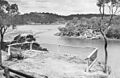
View of the mouth of Lime Kiln Bay, from Hills Lookout toward Illawong and Lugarno, showing former oyster farming racks on left (date unknown).
-
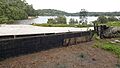
Neverfail Bay with derelict oyster barge and loading ramp (April 2019).
-
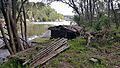
Oyster trays and tar tank at the abandoned oyster farming site on Jewfish Bay (April 2019).
.jpg)
.jpg)
