
Mortdale, New South Wales facts for kids
Quick facts for kids MortdaleSydney, New South Wales |
|||||||||||||||
|---|---|---|---|---|---|---|---|---|---|---|---|---|---|---|---|

Morts Road, Mortdale
|
|||||||||||||||

Mortdale
Location in New South Wales
|
|||||||||||||||
| Population | 10,745 (2021 census) | ||||||||||||||
| Established | 1885 | ||||||||||||||
| Postcode(s) | 2223 | ||||||||||||||
| Elevation | 43 m (141 ft) | ||||||||||||||
| Location | 17 km (11 mi) south of Sydney CBD | ||||||||||||||
| LGA(s) | Georges River Council | ||||||||||||||
| State electorate(s) | Oatley | ||||||||||||||
| Federal Division(s) | Banks | ||||||||||||||
|
|||||||||||||||


Mortdale is a suburb in southern Sydney, New South Wales, Australia. It's about 20 kilometers south of Sydney's main city area. Mortdale is part of the St George area and is managed by the Georges River Council. The suburb reaches south to Lime Kiln Bay, which is on the Georges River. A small area called Mortdale Heights is also part of the suburb.
Contents
- Mortdale's Past: How it Grew
- Shopping and Businesses in Mortdale
- Getting Around Mortdale
- Places of Worship
- Schools in Mortdale
- Parks and Waterways to Explore
- Mortdale's Important Places
- Sports and Recreation
- Mortdale in Pop Culture
- Who Lives in Mortdale?
- Famous People from Mortdale
- Mortdale Heights: A Special Area
- Images for kids
Mortdale's Past: How it Grew
Mortdale has had many names over time, like Mort's Road and Mort Dale. The suburb was named after Thomas Sutcliffe Mort (1816–1878). He was a famous Sydney businessman who helped start refrigeration for shipping meat. He also built Mort's Dock in Balmain. Thomas Mort bought the land from Robert Townson.
A small farming community began when the land around Mort's Road was divided into farms. The Hurstville Steam Brick Company, also known as Judds Brickworks, started in 1884. Its tall brick chimneys were easy to spot. The first homes were built near the Brickworks in 1885.
The railway line was built through the area around the same time. This railway split two main farms, Kemp's orange orchard and Parkes's farm. These farms were then divided into smaller blocks for houses by 1894. The suburb officially became Mortdale when the railway station opened with that name on March 20, 1897.
The local school opened in January 1889. A post office and grocery store opened in November of the same year. Mortdale became a popular place for soldiers returning from World War I to live in the 1920s.
In 1921, some people wanted Mortdale to become its own separate town, away from Hurstville. An official review in 1923 decided against this change.
Around the same time, there was also a push to change Mortdale's name. This was because it sounded like Mortlake and because "Mortdale" can mean "Valley of the Dead" in Latin. People suggested names like Leyton, Montrose, and Boronia. A final list of names was approved, but the name was never changed.
Shopping and Businesses in Mortdale
Mortdale is mostly made up of homes. However, it also has some shops and industrial areas in its north-west corner. The main shopping area is on Morts Road and Pitt Street, close to Mortdale railway station. Larger businesses and factories are found along Boundary Road.
Some streets near the shopping area are named after famous streets in Sydney's city center. These include George Street, Martin Place, Pitt Street, Macquarie Place, and Oxford Street. This is the only group of streets in Sydney named this way.
-
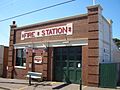
Mortdale Fire Station
-
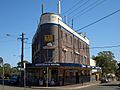
Mortdale Hotel
-
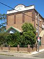
Woronora Lodge, Mortdale Masonic Centre (now demolished)


Getting Around Mortdale
Mortdale railway station is on the Illawarra railway line, which is part of the Sydney Trains network. A train journey from Mortdale to the city takes about 30 minutes. Mortdale is on the T4 train line. This line is separate from the rest of the network, which can help avoid delays.
U-Go Mobility buses also serve Mortdale. Services 944, 945, and 955 run throughout the week. There are fewer services on weekends.
Places of Worship
- Christ Church Anglican
- Mortdale Uniting Church
- Mortdale Oatley Baptist Church
- Church of Jesus Christ of Latter Day Saints (Mormons)
- Hurstville District Christadelphian Ecclesia
- Mortdale Spiritual Church
Schools in Mortdale
- Mortdale Public School
- Carinya Special School
- Marist College Penshurst
- Penshurst West Public School
Parks and Waterways to Explore
- Mortdale Memorial Park, Renown Park, Jubilee Park, Hurstville Golf Course, Mick Downes Reserve, Oatley Heights Park, Lime Kiln Bay Reserve, Olds Park, Edith Park, Beatty Street Reserve, Ruby Wing Reserve, Paddy Tyler Reserve, Milsop Place Reserve, Sunlea Avenue Reserve, Treloar Avenue Reserve, Walter Street Reserve, Nicol Murray Reserve, Lesley Crescent Reserve.
- Georges River, Lime Kiln Bay, Dairy Creek.
Mortdale's Important Places
- Historic Buildings: Mortdale Fire Station, Old Police Station, Mortdale Hotel, Mortdale railway station, Mortdale RSL Club, St George Masonic Club, Mortdale Scout Hall, Mortdale Senior Citizens Centre, Ellen Subway underpass.
- Mortdale Memorial Park: This park has large fig trees around its edges. It also features a classic rotunda and a special War Memorial. The park is a popular spot for picnics, weddings, and concerts.
Sports and Recreation
- Hurstville Golf Course: An 18-hole golf course.
- Ken Rosewall Tennis Centre: Has 8 tennis courts next to the golf course.
- Renown United Rugby League Club: Plays at Renown Park in Mortdale.
- Mortdale Heights Cricket Club: Plays at Oatley Park Oval.
- Hurstville Small Bore Range: A rifle range for rimfire shooting, located across from the golf course.
- Beatty Street Reserve: Has cricket nets.
- Jubilee Park: Features a netball court.
Mortdale in Pop Culture
Mortdale has sometimes been called the "Valley of the Dead" or "Death Valley." This comes from the Latin word mort (meaning "death") and the English word dale (meaning "valley").
In 1992, Su Cruickshank wrote a book called 'Bring A Plate to The Mortdale Scout Hall - The Autobiography of a Fat Tart Complete with Recipes'.
Who Lives in Mortdale?
According to the 2021 census, there were 10,745 people living in Mortdale. About 49.4% were male and 50.6% were female. The average age was 40 years old.
About 34.9% of residents were born outside Australia. The top countries of birth were China (7.7%), Nepal (2.3%), England (2.2%), and Hong Kong (1.6%). English was the main language spoken at home by 62.6% of residents. Other common languages included Mandarin (8.1%), Cantonese (5.2%), Greek (2.9%), Macedonian (2.7%), and Nepali (2.4%).
For religious beliefs, 32.1% said they had no religion. Other common responses were Catholic (24.4%), Anglican (11.2%), and Orthodox (8.0%).
Most homes in Mortdale were occupied by two-parent families (50.3%). Single-parent families made up 12.9%, and couples without children made up 35.2%. About 31.8% of households were buying their homes, 28.7% were renting, and 37.3% owned their homes outright.
About 56.4% of homes were separate houses. Another 13.8% were semi-detached homes, and 29% were apartments. About 41.0% of households had one vehicle, and 34.7% had two.
Famous People from Mortdale
- Mark Gasnier - A rugby league player for St George.
- Reg Gasnier - Another rugby league player for St George.
- J. H. Leonard - An illustrator.
- Billy Smith - A rugby league player for St George.
- Ruby Violet Payne-Scott (1912-1981) - A physicist, radio astronomer, and schoolteacher.
Mortdale Heights: A Special Area
Mortdale Heights is a small area located by the water. It sits between the Georges River and the western part of Mortdale in southern Sydney. Mortdale Heights is about 20 kilometers south of Sydney's city center. It is also part of the Georges River Council area.
This small, elevated area is bordered by Oatley Heights Park and Lime Kiln Bay to the south. To the west, it's bordered by Hurstville Golf Course. Mortdale Heights is known for its unusual street names. Most of them start with the letter "B" and have a Scottish background.
History of Mortdale Heights
The name "Mortdale Heights" was used as early as 1919. However, there were only a few scattered homes there at that time. The area was not fully divided into blocks for sale until 1924. That's when about 300 blocks were made available. The area didn't fully develop until shortly after World War II.
Community Life in Mortdale Heights
- A row of about 12 shops was built along Balmoral Road in the 1950s. Many of these have since been turned into homes.
- Beatty Street Reserve includes part of an old quarry site. This quarry was cleared by the Mortdale Heights Progress Association in 1954. A playground for children was built on the top part in 1955. Cricket nets were later put in the quarry section.
- The Girl Guides Hall is located next to Beatty Street Reserve.
- The Mortdale Heights Cricket Club started in 1957. It is one of the oldest clubs in the Georges River St George District Cricket Association. Their home games are played at Oatley Park Oval.
- Lime Kiln Bay Reserve, which is part of Oatley Heights Park, is a natural bushland area. It surrounds Lime Kiln Bay and extends into nearby Oatley Park.
Images for kids
-
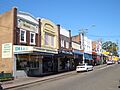
Morts Road, Mortdale
