Woronora River facts for kids
Quick facts for kids Woronora |
|
|---|---|

Woronora River
|
|

NASA satellite view of Greater Metropolitan Sydney, with the location of the mouth of the Woronora River, as marked
|
|
| Country | Australia |
| State | New South Wales |
| Region | Greater Metropolitan Sydney |
| LGA | Sutherland Shire |
| Physical characteristics | |
| Main source | Illawarra escarpment |
| 2nd source | Waratah Rivulet near Darkes Forest 353 m (1,158 ft) 34°23′17″S 150°54′18″E / 34.38806°S 150.90500°E |
| River mouth | confluence with the Georges River between Como and Illawong 0 m (0 ft) 33°59′40″S 151°4′3″E / 33.99444°S 151.06750°E |
| Length | 36 km (22 mi) |
| Basin features | |
| River system | Georges River catchment |
| Basin size | 174 km2 (67 sq mi) |
| Tributaries |
|
| Dam | Woronora (1941) |
The Woronora River is a beautiful river in New South Wales, Australia. It flows through the Sutherland Shire area of Sydney, about 22 kilometers (14 miles) south of the city center. This river is a perennial river, meaning it flows all year round.
The name 'Woronora' comes from the Aboriginal Dharug language. It means "black rocks." Over time, the spelling of the name has changed a bit. It was first used for this river, which then gave its name to a local area and even a suburb.
The Woronora River starts near Darkes Forest from a small stream called Waratah Rivulet. It flows mostly north for about 36 kilometers (22 miles). Along the way, three smaller streams join it. Finally, it meets the Georges River between the suburbs of Como and Illawong.
Contents
Where the Woronora River Flows
The Woronora River begins from Waratah Rivulet, close to Darkes Forest. It travels north for about 36 kilometers (22 miles). Three smaller streams join it before it reaches the Georges River. This meeting point is between the areas of Como and Illawong.
The river's total area, called its catchment, is about 174 square kilometers (67 square miles). The upper part of the river is managed by the Sydney Catchment Authority. The lower part is looked after by the Sutherland Shire Council. A lot of the river's path goes through beautiful natural areas. These include the Dharawal State Conservation Area, Heathcote National Park, and the Royal National Park. The river drops about 354 meters (1,161 feet) from where it starts to where it ends.
Woronora Dam and Water Supply
The Woronora River is home to the Woronora Dam, which was opened in 1941. This dam creates a large body of water called Lake Woronora. The lake can hold about 71,790 megaliters of water. That's a huge amount!
The dam was built to help supply water to southern Sydney and the northern Illawarra region. It plays an important role in making sure people have enough water for their homes and daily lives.
Bridges Over the River
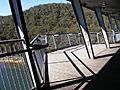
Several bridges cross the Woronora River. In the suburb of Woronora, there are different types of bridges. You can find high-level and low-level road bridges. There is also a footbridge for people to walk across.
Another road bridge on Heathcote Road connects Heathcote and Holsworthy. This bridge also crosses the river. Near an area called "The Needles" in Engadine, a footbridge connects to Barden Ridge. "The Needles" got its name from pointed rocks that were just below the water's surface.
The Meaning of "Woronora"
The name 'Woronora' comes from the Australian Aboriginal Dharug language. In this language, 'Woronora' means "black rocks." It's a name that describes a feature of the river's landscape.
Records show that the spelling of the name has changed over time. Early spellings included Wooloonora and Wolonora. The name was first given to the river. Later, it was used for an electoral district, a local road, and finally, the suburb itself.
Images for kids
-
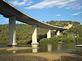
Woronora River Bridge, view towards Sutherland
-
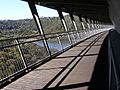
Woronora River Bridge walkway.
-
-