
Lugarno, New South Wales facts for kids
Quick facts for kids LugarnoSydney, New South Wales |
|||||||||||||||
|---|---|---|---|---|---|---|---|---|---|---|---|---|---|---|---|

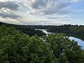
Boardwalk and Lugarno Marina on Georges River
|
|||||||||||||||
| Population | 5,606 (2016 census) | ||||||||||||||
| Postcode(s) | 2210 | ||||||||||||||
| Elevation | 72 m (236 ft) | ||||||||||||||
| Location | 23 km (14 mi) south-west of Sydney CBD | ||||||||||||||
| LGA(s) | Georges River Council | ||||||||||||||
| State electorate(s) | Oatley | ||||||||||||||
| Federal Division(s) | Banks | ||||||||||||||
|
|||||||||||||||
Lugarno is a suburb in the southern part of Sydney, New South Wales, Australia. It is about 23 kilometres south of the main city centre of Sydney. Lugarno is part of the Georges River Council area.
This suburb sits on the northern bank of the Georges River. It is famous for its many areas of natural bushland. Lugarno is next to Peakhurst and Peakhurst Heights to the north. Other nearby suburbs include Alfords Point, Illawong (across the Georges River), Padstow Heights (across Salt Pan Creek), and Oatley (across Lime Kiln Bay).
Contents
History of Lugarno
First People of the Land
The land where Lugarno is today was originally home to Aboriginal people. It was either the traditional land of the Dharug people or the coastal Eora people. Both groups spoke a similar language. The Tharawal people lived on the south side of the Georges River.
The Georges River Council officially recognises the Biddegal/Bidjigal/Bedegal clan of the Eora people. They are the first inhabitants and traditional owners of all the land and water in the Georges River area.
Early European Contact
One of the first times British settlers met Aboriginal people was on January 20, 1788. Arthur Phillip and Philip Gidley King explored the Georges River. They landed near what is now Lime Kiln Bay. Here, they had a brief disagreement with local people. Later that day, they had a peaceful meeting at the end of Lime Kiln Bay.
The settlers were looking for fresh water. Since they did not find enough, they moved to Port Jackson. This is where the city of Sydney began six days later.
How Lugarno Got Its Name
Lugarno was named in 1843 by surveyors Major Sir Thomas Livingstone Mitchell and William Romaine Govett. They named it after Lake Lugano in Switzerland. An extra 'r' was added to the suburb's name.
Early land grants were given out in the 1830s and 1850s. For example, Thomas Lawrence received 120 acres (0.49 km2) of land in 1831.
Developing the Area
The area between Arncliffe and Lugarno used to be covered in thick forests. A road called Illawarra Road was built by convicts in 1841. This road went through the forest down to the Georges River. Today, parts of this old road are known as Forest Road.
A punt (a type of boat that pulls itself across a river using a cable) operated across the Georges River from Lugarno starting in 1843. A regular ferry service ran from 1887 until 1974. This service stopped when the Alfords Point Bridge opened, making it easier to cross the river by car.
For many years, there was an oyster farming industry in the Georges River near Lugarno. However, this industry ended in the mid-1990s because of a disease called QX disease.
In the 1960s, Lugarno began to develop into a mostly residential area. More land became available for building homes.
H. V. Evatt Memorial Park
H. V. Evatt Memorial Park is built on volcanic soil, which is quite rare in Sydney. This area used to be a market garden until around 1961. The pond in the park was originally an irrigation dam for the garden.
After the market garden closed, the land was almost used for housing. But it was saved and turned into open space and sports fields. The natural shape of the hill was changed to create flat playing fields.
Many Roundabouts
A survey in 2012 found that Lugarno has a lot of roundabouts for its size. With about 5,500 people and 7 roundabouts, it has one roundabout for every 785 people. This was said to be the most per person in the Southern Hemisphere at the time.
Nature and Waterways
Lugarno is home to several parks and natural areas. These include Georges River National Park, CF Williams Reserve, HV Evatt Park, and Taylors Reserve.
The suburb is also surrounded by important waterways. These include the Georges River, Salt Pan Creek, Soily Bottom Point, Gertrude Point, Edith Bay, Boggywell Creek, and Lime Kiln Bay.
Places of Worship
Lugarno has several churches for its community. These include St Stephens Anglican Church, Lugarno-Peakhurst Uniting Church, and the Church of Samoa Parish of Sydney.
Getting Around Lugarno
Two bus services run in Lugarno, both operated by U-Go Mobility.
- The 943 bus goes between Lugarno and Hurstville, passing through Penshurst.
- The 942 bus travels between Lugarno and Campsie. It goes through Riverwood, Roselands, Wiley Park, Lakemba, and Belmore.
Sports and Fun
Lugarno offers many sports and recreation activities.
- Gannons Park is the home ground for two soccer clubs: Lugarno F.C. and Forest Rangers FC.
- H.V Evatt Park is where The Georges River Rugby Club (known as The Dropbears) plays. It is also used by the St George Junior Baseball Club and Penshurst RSL Rugby League Club.
- The Lugarno-Peakhurst Uniting Church organises a netball competition at Olds Park in Penshurst.
The Lugarno Football Club is a very active soccer club in the area. In a recent season, the club had 42 teams and over 500 registered players. These players ranged in age from under 6 to over 45, including both boys and girls.
People of Lugarno
According to the 2006 census, Lugarno had a population of 5,707 people.
- About 19.1% of residents were born overseas. The top countries of birth were the United Kingdom (3.1%), China (1.9%), and Greece (1.5%).
- English was the main language spoken at home by 76.0% of residents. Other common languages included Greek (6.3%), Arabic (2.6%), and Cantonese (2.2%).
- The most common religions were Catholic (30.2%), Anglican (22.7%), and Orthodox (11.9%).
Schools in Lugarno
Lugarno has one school, Lugarno Public School. It first opened its doors in 1933.
Images for kids
-
The Georges River as viewed from Lugarno

