
Roselands, New South Wales facts for kids
Quick facts for kids RoselandsSydney, New South Wales |
|||||||||||||||
|---|---|---|---|---|---|---|---|---|---|---|---|---|---|---|---|
.jpg)
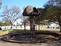
Post-War suburban housing on Leslie Street (2012)
|
|||||||||||||||
| Population | 11,579 (2016 census) | ||||||||||||||
| Established | 1987 | ||||||||||||||
| Postcode(s) | 2196 | ||||||||||||||
| Elevation | 58 m (190 ft) | ||||||||||||||
| Location | 16 km (10 mi) SW of Sydney CBD | ||||||||||||||
| LGA(s) | City of Canterbury-Bankstown | ||||||||||||||
| State electorate(s) |
|
||||||||||||||
| Federal Division(s) | Watson | ||||||||||||||
|
|||||||||||||||
Roselands is a lively suburb located in the south-west of Sydney, New South Wales, Australia. It is about 16 kilometres (10 miles) from the heart of Sydney. Roselands is part of the City of Canterbury-Bankstown area. It is known for being one of the biggest suburbs in Sydney that does not have its own train station.
Contents
Exploring Roselands' Natural Features
Roselands is situated in the area where water flows into the Cooks River. The soil here is mostly clay. This clay soil comes from a type of rock called Wianamatta shale. Roselands is also on the eastern edge of a large flat area known as the Cumberland Plain. This plain stretches all the way to the Hawkesbury River and even towards the Blue Mountains. The land in Roselands has gentle, rolling hills. Before people settled here, the area was covered in open forests of eucalypt trees.
A Look Back at Roselands' Past
Who Lived Here First?
The very first people to live in the Roselands area were Australian Aboriginals. When British settlers arrived in 1788, the local Aboriginal people belonged to the Darug language group. They called themselves Kuri or Koori. The new colonial government started giving out land grants in this area around 1810.
How Roselands Grew Over Time
This area was originally part of the nearby suburb of Punchbowl. It still shares the same postcode, 2196. In 1842, a man named H.R. Morgan was given land here. Later, around 1880, John Fenwick bought about 100 acres (0.4 square kilometres) of land. He built a house called Belmore House on this land. This house was later taken down to make way for the Roselands Shopping Centre. The closest train line was built to Belmore in 1895. It was then extended to Bankstown in 1909.
The name "Roselands" comes from a plant nursery that used to be on this land. Later, a golf course with the same name was built. This golf course was eventually used to build the large shopping centre. Roselands officially became its own suburb on 9 February 1987. This happened after many years of local residents and politicians asking for it.
Shopping and Business in Roselands
Roselands is famous for its large shopping centre, the Roselands Shopping Centre. This centre was one of the first fully enclosed shopping malls in Australia. It opened in October 1965. When it first opened, it had a big Grace Bros Department Store, which is now Myer. It also had a single movie cinema and a unique indoor water feature that looked like falling rain, called the 'raindrop fountain'. Roselands also had Australia's first ever food court, called Four Corners.
The shopping centre was built on what used to be a golf course. It was designed for people who drove cars, so it had lots of parking. Many local bus services were changed to go to the new shopping centre when it opened. Roselands Shopping Centre has been updated many times over the years.
Getting Around Roselands
The main road that goes through Roselands is King Georges Road. This road is an important link that connects the northern parts of Sydney to the southern beaches. King Georges Road also connects Roselands to the M5 South Western Motorway. This motorway makes it easy to get to Sydney's International Airport, which is about a 15-minute drive east. The motorway also goes west towards Canberra and Melbourne. The closest train station to Roselands is in the neighbouring suburb of Punchbowl.
Fun and Activities in Roselands
Roselands offers several places for sports and recreation. The Lantern Club is a popular spot located on Roselands Avenue. If you enjoy swimming, the Roselands Aquatic Centre is on Centre Avenue, right across from the shopping centre. For soccer fans, the Roselands soccer club is located at Bennett Park.
Who Lives in Roselands?
The 2016 Census gives us a picture of the people living in Roselands.
- About 44.5 per cent of people in Roselands were born outside of Australia.
- The most common birthplaces for these residents were Lebanon (5 per cent) and People's Republic of China (3.8 per cent).
When it comes to family background:
- The largest group claimed Greek ancestry (12.4 per cent).
- This was followed by people with Lebanese backgrounds (12.3 per cent).
- Thirdly, 11.3 per cent of residents claimed Australian descent.
Regarding languages spoken at home:
- English is the most common language, spoken by 35.9 per cent of residents.
- Arabic is spoken by 16.6 per cent of people at home.
- Greek is spoken by 12.2 per cent at home.
In terms of religion:
- Christianity is the most common faith, with 60.5 per cent of residents identifying as Christian.
- Within Christianity, the largest groups are Catholic (24.3 per cent) and Orthodox (17.3 per cent).
- Islam is the second largest religious group, followed by 18.8 per cent of residents.
Images for kids
-
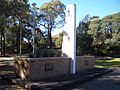
Memorial, Roselands Avenue
-
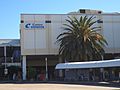
Roselands Shopping Centre
-
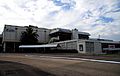
Roselands Shopping Centre
-
Roselands Bowling Club (Old clubhouse demolished, replaced by Lantern Club)
-
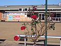
Unused Water Fountain, Roselands Avenue


