Narwee, New South Wales facts for kids
Quick facts for kids NarweeSydney, New South Wales |
|||||||||||||||
|---|---|---|---|---|---|---|---|---|---|---|---|---|---|---|---|

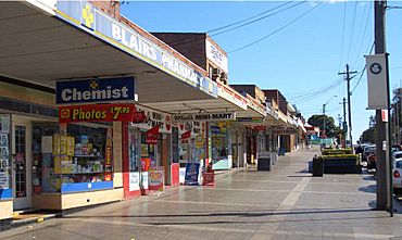
Shops on the south side of Broad Arrow Road
|
|||||||||||||||
| Population | 5,618 (2016 census) | ||||||||||||||
| Postcode(s) | 2209 | ||||||||||||||
| Elevation | 47 m (154 ft) | ||||||||||||||
| Location | 18 km (11 mi) south-west of Sydney CBD | ||||||||||||||
| LGA(s) |
|
||||||||||||||
| State electorate(s) |
|
||||||||||||||
| Federal Division(s) | |||||||||||||||
|
|||||||||||||||
Narwee is a suburb located in southern Sydney, New South Wales, Australia. It is about 18 kilometres south of the main city centre of Sydney. Narwee is part of the St George area. It falls under two local councils: City of Canterbury-Bankstown and Georges River Council. The postcode for Narwee is 2209, which it shares with its neighbour, Beverly Hills.
The main road in Narwee is Broadarrow Road. It stretches from King Georges Road in Beverly Hills to past Bonds Road in Riverwood. This road also marks the boundary between the southern part of the City of Canterbury-Bankstown and the northern part of the Georges River Council areas.
Contents
Narwee's History
The name Narwee comes from an Aboriginal word meaning "sun." This is a fitting name for an area that was once called 'Sunning Hill Farm'. The exact Aboriginal language or dialect the word came from is not fully clear.
Many suburbs in Sydney that grew in the 1930s have similar Aboriginal names. For example, nearby Panania and Jannali are two of them. Jannali is thought to mean "moon." It was supposedly named around the same time as Narwee, almost like a "sister suburb."
How Narwee Grew
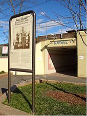
Narwee got its name when the railway station opened on December 21, 1931. At that time, most people living there were poultry farmers or grew vegetables for markets. A city florist even had a large garden west of the railway station.
After the railway arrived, people started buying land to build homes. Not much building happened during the Great Depression or World War II. However, the suburb grew very quickly in the 1950s. Many young families moved into the area during this time. The local post office opened in 1948.
Early Land and Farms
Narwee Primary School is built on land that was first given to Richard Podmore in 1809. He was a free settler who came to New South Wales as a soldier in 1792. Another soldier, Richard Tuckwell, owned land between today's Penshurst Road and King Georges Road. Back then, the area was covered with a very thick forest of ironbark trees.
Tuckwell and Podmore later sold their land to Patrick Moore and Robert Gardner in 1819 and 1820. Moore and Gardner were former prisoners who had become free settlers. Robert Gardner, known as "Bob the Gardener," began clearing trees and creating a farm on Podmore's land. He called it "Sunning Hill Farm." This farm later grew to include more land next door.
In those early days, there were very few farms in the area. People mostly made a living by cutting down trees. They sold the logs for firewood and timber to build houses and boats. Narwee wasn't known as a specific place yet; it was just called "Bob the Gardener's Farm." So few people lived there that bushrangers could easily hide in the forest for weeks without being found.
Shopping and Services
The main shopping area in Narwee is on Broad Arrow Road. It runs right next to Narwee railway station. Like many smaller suburbs, Narwee used to have two banks, Westpac and Commonwealth. Now, both banks have closed. However, the post office is still open for residents. The Narwee Hotel is also very close to the train station, just a two-minute walk away.
Getting Around Narwee
Narwee railway station is part of the Airport & South Line on the Sydney Trains network. From Narwee, you can travel west to Riverwood or east to Beverly Hills.
You can find more details about bus services that connect to the area by looking up the Narwee railway station information.
Places of Worship
The biggest church in the Narwee area is the Narwee Baptist Church.
Schools in Narwee
Narwee has a public primary school for younger students. It also used to have a high school called Narwee High School. This high school was located at the highest point in the suburb. However, it closed in 2001. The land where the high school once stood has now been turned into a group of residential houses.
Narwee's Population
According to the 2011 census, about 4,956 people usually lived in Narwee. Many different cultures and backgrounds make up the community. About 43.7% of residents were born in Australia. Other people came from countries like China, Hong Kong, Indonesia, Lebanon, and Greece.
English is spoken by many residents at home. However, other common languages include Cantonese, Mandarin, and Arabic. The community also has a mix of different religious beliefs, including Catholic, no religion, Anglican, Buddhist, and Orthodox.
 | Janet Taylor Pickett |
 | Synthia Saint James |
 | Howardena Pindell |
 | Faith Ringgold |


