Hawkesbury River facts for kids
Quick facts for kids Hawkesbury-Nepean River |
|
|---|---|
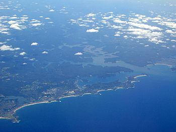
This picture shows where the Hawkesbury River meets Broken Bay and flows into the Tasman Sea, looking over Sydney's Northern Beaches.
|
|
| Native name | Deerubbun |
| Country | Australia |
| State | New South Wales |
| Region | Greater Metropolitan Sydney |
| Physical characteristics | |
| Main source | Nepean River north of Penrith |
| 2nd source | Grose River |
| River mouth | Broken Bay west of Lion Island 33°33′53.9994″S 151°18′0″E / 33.564999833°S 151.30000°E |
| Length | 120 km (75 mi) |
| Basin features | |
| Basin size | 21,624.1 km2 (8,349.1 sq mi) |
| Tributaries |
|
| Islands | Milson Island, Peat Island, Spectacle Island, Long Island, and Dangar Island |
The Hawkesbury River (also called Hawkesbury-Nepean River) is a large river system in New South Wales, Australia. It flows west and north of Sydney. This river is like a "drowned valley" where the sea has filled in a river valley. It is strongly affected by the tide.
The Hawkesbury River and its main branch, the Nepean River, almost surround the city area of Sydney. The Hawkesbury River starts where the Nepean River and the Grose River meet, north of Penrith. It then flows for about 120 kilometres (75 mi) (75 miles). It travels northeast and then southeast to its mouth at Broken Bay. This is about 15 kilometres (9.3 mi) (9 miles) from the Tasman Sea.
The Hawkesbury River is the main river that flows into Broken Bay. Other rivers like Brisbane Water and Pittwater also join Broken Bay. From there, the water flows out into the Tasman Sea, north of Barrenjoey Head. The total area that drains into the river is about 21,624 square kilometres (8,349 sq mi) (8,349 sq mi). This area is managed by the Hawkesbury–Nepean Catchment Management Authority.
Long ago, Aboriginal peoples lived near the Hawkesbury River. These groups included the Darkinjung, Dharug, Eora, and Kuringgai peoples. They used the river for food and as a place to trade goods.
Contents
River's Journey
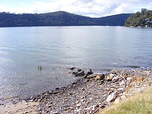
The Hawkesbury River system begins with smaller rivers like the Avon, Cataract, and Cordeaux River. These rivers start close to the sea, about 80 kilometres (50 mi) (50 miles) south of Sydney. They flow northwest, away from the coast. These streams then join to form the Nepean River. The Nepean River flows north past towns like Camden and Penrith.
Near Penrith, the Warragamba River joins the Nepean. The Warragamba River flows through a deep valley in the Blue Mountains. It collects water from many other rivers, including the Wollondilly River, Nattai River, Kowmung River, and Coxs River. These rivers drain a large area on the eastern side of the Great Dividing Range. Another important part of the upper Hawkesbury system is the Grose River, which starts in the Blue Mountains near Mount Victoria.
Once the Hawkesbury River officially forms, it generally flows north. It has many bends and turns. First, it passes the towns of Richmond and Windsor. These are the biggest towns along the river. At Windsor, South Creek joins the river. This creek carries water from Sydney's western suburbs.
As the river flows north, it enters a more rural area with smaller towns. It passes Sackville and Lower Portland. Here, the Colo River joins it. The Colo River drains the northern part of the Blue Mountains.
From Lower Portland, the Hawkesbury River continues north to Wisemans Ferry. Here, the Macdonald River joins it. The river then turns east, and the land around it becomes steeper and more rugged. At Spencer, Mangrove Creek flows into the river from the north. From this point to the river's mouth, it's hard to reach the river by road.
Near Milsons Passage, Berowra Creek joins the river from the south. Around Brooklyn, major roads and train lines cross the river. Finally, the river reaches the ocean at Broken Bay. From where the Nepean and Grose Rivers meet to the sea, the Hawkesbury River is about 120 kilometres (75 mi) (75 miles) long.
Islands in the River
The Hawkesbury River has several islands. Going downstream (towards the sea), these islands include:
- Barr Island
- Milson Island
- Snake Island
- Peat Island
- Spectacle Island
- Long Island
- Dangar Island
- Lion Island
River Crossings
Even though the Hawkesbury River forms a natural border for Sydney, there are not many fixed bridges or crossings over the main river. Here are some of the crossings, going downstream:
| Crossing name | North bank location | South bank location | What it's used for | Image |
|---|---|---|---|---|
| Richmond Bridge | North Richmond | Richmond | This bridge carries the historic Bells Line of Road. It used to carry a railway line. | |
| Windsor Bridge | Freemans Reach | Windsor | This bridge carries the Putty Road. | |
| Sackville Ferry | Sackville | This is a ferry that carries cars using a cable. |  |
|
| Lower Portland Ferry | Lower Portland | This is another ferry that carries cars using a cable. | ||
| Webbs Creek Ferry | Wisemans Ferry | A cable ferry just upstream from Wisemans Ferry town. |  |
|
| Wisemans Ferry | This is a cable ferry at Wisemans Ferry town. It carries the old Great North Road. |  |
||
| Brooklyn Bridge | Mooney Mooney | Kangaroo Point | This bridge carries the Sydney-Newcastle Freeway. It runs next to Peats Ferry Bridge. |  |
| Peats Ferry Bridge | This is an older bridge that carries the Pacific Highway. | |||
| Hawkesbury River Railway Bridge | Cogra Point | Brooklyn | This bridge carries the Main Northern railway line. |  |
In the lower parts of the river, there are also a few ferries that carry passengers. These include the Palm Beach Ferry service. It goes from Palm Beach to Ettalong and Wagstaffe. The Hawkesbury River Ferries service goes from Brooklyn to Dangar Island and Little Wobby.
River History
Aboriginal History
The Aboriginal name for the Hawkesbury River was Deerubbun. This name was written down in 1870. The main Aboriginal groups who lived along the river were the Wannungine and the Darkinyung people. Their lands covered large areas of the Hawkesbury. The Eora and Guringai people also lived along the river banks.
History Since European Settlement
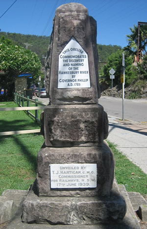
In 1789, two groups explored the Hawkesbury and Nepean Rivers. It took about three years for them to realize these were parts of the same river system. The Hawkesbury River was important during the Hawkesbury and Nepean Wars. These were conflicts between the early British settlers and the local Indigenous clans. These events happened between the late 1780s and late 1810s.
During the 1800s, the Hawkesbury River was a major way to transport food to Sydney. Boats would wait in safe bays like Broken Bay and Pittwater. They would then sail to Sydney when the weather was good. In 1864, a railway line opened from Sydney to Windsor. This meant farm produce could be sent upriver and then by train. However, by the 1880s, parts of the river became too shallow for large boats. Sackville became the main port for boats coming from the sea. Until the late 1800s, coastal ships connected Sackville to Sydney.
Governor Phillip gave the Hawkesbury River its current name in June 1789. He named it after Charles Jenkinson, who was known as Baron Hawkesbury. This name came from the village of Hawkesbury Upton in England. In 1939, a monument was put up in Brooklyn to remember the naming of the river. In 1794, 22 families were given land near Windsor. Around the same time, conflicts began between Aboriginal people and the new settlers.
How the River is Used
Boating and Travel
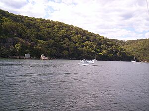
You can travel by boat on the Hawkesbury River all the way from Windsor to the sea. There are no dams or locks on the river. The tide affects the water level as far inland as Windsor.
Today, most farm goods are moved by road. But the river is still the only way to reach many isolated homes and communities. This is especially true in the lower parts of the river. Here, the land is very steep and rugged, making it hard to build roads. Because of this, Australia's last riverboat postman still operates. This boat delivers mail to properties along the river between Brooklyn and Spencer.
Sports and Fun
The Hawkesbury Canoe Classic is a long canoe race, about 111 kilometres (69 mi) (69 miles). It happens every October or November. The race starts at Windsor and ends at Brooklyn. The Bridge to Bridge Water Ski Classic is a water ski race that goes the other way. It starts at Dangar Island and finishes at Windsor.
The Australian part of the Red Bull Cliff Diving World Series also takes place in Hawkesbury. Windsor and Dargle ski park on the Hawkesbury River also host circuit boat races each year. Boats from all over the country come to compete.
Fishing
The Hawkesbury River estuary (where the river meets the sea) is very important for fishing. According to the Hawkesbury Nepean Catchment Management Authority, it is the second-largest place in New South Wales for catching prawns, oysters, and fish for sale. This fishing brings in millions of dollars each year.
See also
 In Spanish: Río Hawkesbury para niños
 | Kyle Baker |
 | Joseph Yoakum |
 | Laura Wheeler Waring |
 | Henry Ossawa Tanner |


