Pittwater facts for kids
Quick facts for kids Pittwater |
|
|---|---|

Aerial view of a part of Sydney's Northern Beaches, with Pittwater and Scotland Island on the left.
|
|
| Country | Australia |
| State | New South Wales |
| Region | Greater Metropolitan Sydney |
| Municipality | Northern Beaches Council |
| Physical characteristics | |
| Main source | McCarrs Creek north of Church Point 33°38′38.3994″S 151°16′55.2″E / 33.643999833°S 151.282000°E |
| 2nd source | Cahill Creek Mona Vale 33°39′59.3994″S 151°18′41.3994″E / 33.666499833°S 151.311499833°E |
| River mouth | Broken Bay West Head and Barrenjoey Head 33°34′47.9994″S 151°18′57.6″E / 33.579999833°S 151.316000°E |
| Length | 10 km (6.2 mi) |
| Basin features | |
| River system | Hawkesbury–Nepean |
| Basin size | 50.8 km2 (19.6 sq mi) |
| Tributaries |
|
| Island | Scotland Island |
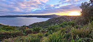
Pittwater is a beautiful waterway located about 40 kilometers (25 miles) north of Sydney, New South Wales, Australia. It's a type of estuary called a "drowned valley," which means it's a river valley that has been filled with sea water. Pittwater helps separate the big city of Sydney from the Central Coast.
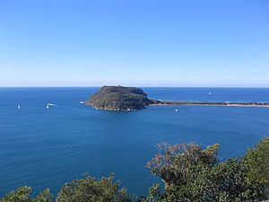
This waterway starts where McCarrs Creek and other smaller streams, like Cahill Creek, meet. It then flows north into Broken Bay, between West Head and Barrenjoey Head. From there, it's less than 1 kilometer (0.6 miles) to the Tasman Sea.
Pittwater covers an area of about 18.4 square kilometers (7.1 square miles). Most of it is managed by the Hawkesbury–Nepean Catchment Management Authority and the Northern Beaches Council. For thousands of years, the Kuringgai people, an Aboriginal Australian group, lived around Pittwater. They used it for food and trade. The name Pitt Water was given in 1788 to honor William Pitt the Younger, who was the Prime Minister of the United Kingdom at that time.
Contents
Exploring Pittwater's Geography
Pittwater stretches from areas like Mona Vale and Warriewood in the south. It follows the eastern side of the Barrenjoey Peninsula towards Palm Beach. On the western side, it follows the Lambert Peninsula towards West Head.
Natural Features and Habitats
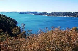
The eastern parts of the Pittwater area are mostly towns and suburbs. However, the western parts are largely covered by Ku-ring-gai Chase National Park. Inside Pittwater, you'll find many smaller bays and coves. These include Careel Bay, Refuge Cove, Saltpan Cove, and Horseshoe Cove. Other spots are Crystal Bay, McCarrs Creek, Browns Bay, Elvina Bay, Lovett Bay, Towlers Bay, Portuguese Bay, Coasters Retreat, and The Basin. Scotland Island is also located right in the middle of this estuary.
Pittwater is home to many different types of natural habitats. You can find mangrove wetlands, saltmarsh areas, sandy flats, and seagrass meadows. Some of these coastal saltmarsh areas are very important and protected.


A Look at Pittwater's History
Aboriginal Heritage
The Kuringgai people, sometimes called Guringai, were the original inhabitants of the lands and waterways north of Sydney Harbour. Their territory included the Lane Cove River, Broken Bay, and even extended to Brisbane Water. Within the Kuringgai group, there were many smaller family units called clans. The Carigal clan was very important in the area around Pittwater. Sadly, in 1789, a disease called smallpox greatly affected the Aboriginal people. Many people became sick and died, with estimates suggesting between 50% and 90% of the population in the coastal area from Botany Bay to Broken Bay. A large number of these were Kuringgai people.
European Settlement and Development
European explorers first mapped Pittwater in 1788. They named it Pitt Water to honor William Pitt the Younger, who was the Prime Minister of Great Britain at the time. The first regular boat service on Pittwater began in 1793. A small boat called the Francis carried settlers and farm goods from Sydney.
By 1803, many private boats started operating between Pittwater, Cowan Creek, and Berowra Waters. These boats often traveled together to stay safe from escaped convicts who sometimes lived along the shore. Many of these boats were built on Scotland Island. They were not strong enough to go out into the open sea beyond Broken Bay. A special customs house operated in Pittwater from 1843 to 1900. A lighthouse, built from sandstone by the government, was finished at Barrenjoey in 1881. Both the Old Customs House and the lighthouse are important historical sites.
As roads and railways were built between 1850 and 1890, boat travel became less common. A railway bridge was built over the waterway in 1899. The last local boat was built in 1912, and regular boat services stopped in 1914. However, since the 1950s, Pittwater has become a popular place to live. It's now a suburban area of Sydney, but it has still kept much of its original charm.
Pittwater Today: Activities and Importance

Today, Pittwater is a very popular spot for water activities. People love to go sailing and fishing here. The area is also important for its natural beauty and wildlife. It includes wetlands, bushland, lagoons, the waterway itself, rock platforms, and beaches.
A famous boat race, the Pittwater to Coffs Harbour Yacht Race, happens every January. It has been held since 1981. In 2016, the race went from Pittwater to Southport in Queensland because the facilities at Coffs Harbour were damaged by storms.
The name Pittwater is also used for several other things:
- The former Pittwater Council, which was a local government area.
- The Electoral district of Pittwater, which is a voting area.
- Pittwater High School, a local school.
- Pittwater Park, a recreational area.
- Little Pittwater Bay, located in Hornsby Shire.
Notable People Connected to Pittwater
The well-known chef Pamela Clark lives in the Pittwater area.
 | Jackie Robinson |
 | Jack Johnson |
 | Althea Gibson |
 | Arthur Ashe |
 | Muhammad Ali |

