
Warriewood, New South Wales facts for kids
Quick facts for kids WarriewoodSydney, New South Wales |
|||||||||||||||
|---|---|---|---|---|---|---|---|---|---|---|---|---|---|---|---|

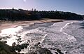
Warriewood Beach
|
|||||||||||||||
| Population | 8,379 (2021 census) | ||||||||||||||
| • Density | 1,995/km2 (5,170/sq mi) | ||||||||||||||
| Postcode(s) | 2102 | ||||||||||||||
| Elevation | 8 m (26 ft) | ||||||||||||||
| Area | 4.2 km2 (1.6 sq mi) | ||||||||||||||
| Location | 26 km (16 mi) north of Sydney CBD | ||||||||||||||
| LGA(s) | Northern Beaches Council | ||||||||||||||
| State electorate(s) | Pittwater | ||||||||||||||
| Federal Division(s) | Mackellar | ||||||||||||||
|
|||||||||||||||
Warriewood is a cool suburb located in northern Sydney, New South Wales, Australia. It's about 26 kilometers north of the main city area, the Sydney central business district. Warriewood is part of the Northern Beaches Council area, which is known for its beautiful beaches.
Contents
Discovering Warriewood's Past
Warriewood got its name from the "Warriewood Estate." This large piece of land was divided up in 1906. A man named Henry F. Halloran bought it from the McPherson family and then created the suburb we know today.
Shopping and Fun in Warriewood
Warriewood has some great places to shop and have fun!
Warriewood Square: Your Shopping Hub
Warriewood Square is a medium-sized shopping center in the southern part of the suburb. It used to be called Centro Warriewood. You can find lots of different stores there.
Local Shops and Entertainment
There are also some smaller shops located near Warriewood Beach on Narrabeen Park Parade. For entertainment, Warriewood has a cinema complex where you can watch movies. There's also an industrial area, a mini putt-putt golf course, and a golf driving range for some outdoor fun. And if you're hungry, there's a McDonald's restaurant!
Learning in Warriewood
Warriewood has good schools for students of different ages.
High School Options
For high school, there's Mater Maria Catholic College, which is a Catholic high school. Many students also attend Narrabeen Sports High or Pittwater High, depending on where they live.
Primary School Choices
The local primary school is North Narrabeen Public School. Some students might also go to Mona Vale Public School, especially if they get into its Opportunity Class.
Homes and Development in Warriewood Valley
Warriewood Valley is an area that has seen a lot of development.
Modern Housing and Planning
The NSW State Government decided this area was a good place for more homes. So, they changed the rules to allow more houses and buildings to be built. This development has also helped clean up the local wetlands and water areas. New ways to manage water were put in place to help prevent flooding.
Types of Homes
In 2016, almost half of the homes in Warriewood were separate houses. About a quarter were semi-detached homes (like duplexes), and another quarter were flats or apartments. This means there's a mix of different housing styles.
Warriewood's Community Facilities
Warriewood has several important facilities for sports and daily life.
Sports Fields and Courts
- Boondah Reserve Sports Fields: These are grass fields used for many sports like soccer, netball, and baseball.
- Boondah Road Sports Courts: These hard courts were finished in 2020. They are used for basketball and netball.
- North Narrabeen Reserve: Even though it's called "North Narrabeen," these sports fields, including "Rat Park," are actually located within Warriewood.
Other Important Infrastructure
- Sewage Treatment Plant: This plant is operated by Sydney Water and helps manage wastewater.
- Warriewood Valley Playground: Also known as Rocket Park or Rocketship Playground, this is a fun place for kids to play.
Getting Around Warriewood
Warriewood has good public transport options, especially buses.
B-Line Bus Service
The B-Line bus service started in November 2017. These buses run between Mona Vale and Wynyard in the city. Warriewood has special undercover bus shelters and a two-story car park for commuters near Pittwater Road.
Local Bus Routes
Besides the B-Line, other main bus routes like the 185, 182, and 199 also travel through the suburb, connecting residents to nearby areas.
Warriewood Wetlands: A Special Place
The Warriewood Wetlands are a very important natural area. They contain several "Endangered Ecological Communities." This means there are special plants and animals living there that need protection because they are rare or at risk.
Famous People from Warriewood
Some well-known people have lived in Warriewood:
- Damien Hardman: A famous surfer.
- Emma Lincoln-Smith: A skeleton racer, which is a sport where you slide head-first down an ice track.
- Holly Lincoln-Smith: A water polo player.
Images for kids
-
Warriewood Beach
