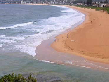
North Narrabeen, New South Wales facts for kids
Quick facts for kids North NarrabeenSydney, New South Wales |
|||||||||||||||
|---|---|---|---|---|---|---|---|---|---|---|---|---|---|---|---|

North Narrabeen Beach
|
|||||||||||||||
| Population | 5,852 (2016 census) | ||||||||||||||
| Postcode(s) | 2101 | ||||||||||||||
| Elevation | 5 m (16 ft) | ||||||||||||||
| Location | 25 km (16 mi) north of Sydney CBD | ||||||||||||||
| LGA(s) | Northern Beaches Council | ||||||||||||||
| State electorate(s) | Pittwater | ||||||||||||||
| Federal Division(s) | Mackellar | ||||||||||||||
|
|||||||||||||||
North Narrabeen is a suburb in northern Sydney, New South Wales, Australia. It's about 25 kilometers north of the main city center. This area is part of the Northern Beaches region and is managed by the Northern Beaches Council.
North Narrabeen is located on the north side of Narrabeen Lagoon. To its north is Warriewood, and to its west is Elanora Heights. To the east, it reaches the ocean at Narrabeen Head. The suburb of Narrabeen is just across the lagoon to the south.
The northern part of Narrabeen Beach is known as North Narrabeen Beach. This ocean beach and the North Narrabeen Surf Lifesaving Club are actually located in the suburb of Narrabeen, south of the lagoon.
Contents
Exploring North Narrabeen's Past
The first land grants in this area were given to early settlers. John Lees received 40 acres, Philip Schaffer got 50 acres, and James Wheeler received 80 acres. These lands were located along the south bank of Mullet Creek. Later, in 1815, Alex Macdonald was granted 80 acres near the beach. By 1857, JT Collins owned 93.5 acres to the west of this land.
Getting Around: Bridges and Trams
For a long time, travelers had to cross Narrabeen Lake by wading through it. This changed in the 1880s when the first bridge was built, making travel much easier. Another bridge was built in 1925 at the mouth of the lagoon on Ocean Street.
In 1913, tram services were extended to Narrabeen. This made it much simpler for people to visit. The whole area around the lake became very popular for holidays and camping. A large camping ground was set up on the north shore of the lagoon. In 1946, the Wakehurst Parkway was opened. This road connected the entire Pittwater area directly to Frenchs Forest and Seaforth.
A Cottage with a Secret Past
Before World War II, a group called the German Labour Front used a cottage at Deep Creek. They held meetings there and hosted German sailors and visitors. There were rumors about what happened at the camp. However, an investigation after the war found no proof of any spying. You can still find some rocks in the area with carvings like swastikas and eagles. These were likely made by the German visitors.
Who Lives in North Narrabeen?
In 2016, a census counted 5,852 people living in North Narrabeen. Most people, about 73.8%, were born in Australia. Other common birthplaces included England (6.9%) and New Zealand (1.7%).
Most people in North Narrabeen, about 85.9%, spoke only English at home. When asked about their religion, the most common answers were:
- No Religion (34.5%)
- Catholic (23.4%)
- Anglican (18.7%)
Learning in North Narrabeen
North Narrabeen has schools for students of different ages. It is home to both a primary school and a high school:
- Narrabeen North Public School
- Narrabeen Sports High School
 | Aaron Henry |
 | T. R. M. Howard |
 | Jesse Jackson |

