Lovett Bay facts for kids
Quick facts for kids Lovett BaySydney, New South Wales |
|||||||||||||||
|---|---|---|---|---|---|---|---|---|---|---|---|---|---|---|---|

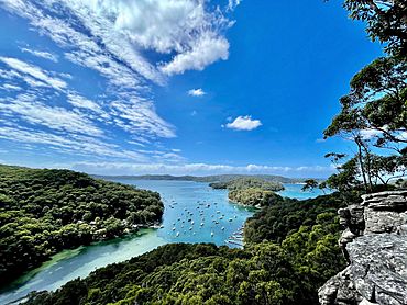
Lovett Bay viewed from Ku-ring-gai Chase National Park
|
|||||||||||||||
| Population | 117 (2021 census) | ||||||||||||||
| Postcode(s) | 2105 | ||||||||||||||
| Elevation | 13 m (43 ft) | ||||||||||||||
| Location | 36 km (22 mi) north of Sydney CBD | ||||||||||||||
| LGA(s) | Northern Beaches Council | ||||||||||||||
| State electorate(s) | Pittwater | ||||||||||||||
| Federal Division(s) | Mackellar | ||||||||||||||
|
|||||||||||||||
Lovett Bay is a beautiful suburb and a calm bay located in northern Sydney, New South Wales, Australia. It's about 36 kilometres north of the main city area of Sydney. This special place is part of the Northern Beaches Council area.
Lovett Bay is nestled within the amazing Ku-ring-gai Chase National Park. It sits right on the western side of Pittwater, a large body of water. Nearby you'll find Elvina Bay, Scotland Island, Church Point, and Morning Bay.
Getting to Lovett Bay
One of the most interesting things about Lovett Bay is how you get there. Even though it's on the mainland, you can only reach it by water! There are no roads leading into Lovett Bay.
Travel by Boat
People who live in Lovett Bay often use their own boats to travel. They can easily commute to Church Point, which is a nearby hub. There's also a public ferry service available. This ferry helps residents and visitors get to and from Lovett Bay. It's a unique way to live and visit!
Exploring Lovett Bay
Lovett Bay is a great spot for outdoor adventures, especially if you love bushwalking. The area is surrounded by the stunning Ku-ring-gai Chase National Park. This park offers many trails and beautiful views.
Bushwalking Trails
You can explore the southern shore of Lovett Bay and its neighbour, Elvina Bay, by following some cool bushwalking trails:
- Elvina Bay Circuit: This trail is a loop that takes you around the area. It even includes access to the top and bottom of the lovely Elvina Waterfalls. It's a perfect spot to see nature's beauty.
- Towers Bay Circuit: This trail starts from Birnie Lookout and goes down towards Lovett Bay. It offers amazing views as you descend.
These trails are a fantastic way to experience the natural beauty and peaceful environment of Lovett Bay. Remember to wear comfortable shoes and bring water!
 | Laphonza Butler |
 | Daisy Bates |
 | Elizabeth Piper Ensley |

