Ku-ring-gai Chase National Park facts for kids
Quick facts for kids Ku-ring-gai Chase National ParkNew South Wales |
|
|---|---|
|
IUCN Category II (National Park)
|
|
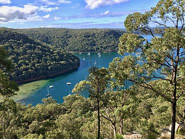
The steep wooded ria that forms Towlers Bay, is typical of the Ku-ring-gai Chase terrain.
|
|
| Nearest town or city | Sydney |
| Established | December 1894 |
| Area | 149.77 km2 (57.8 sq mi) |
| Visitation | 2 million (in 2001) |
| Managing authorities | NSW National Parks & Wildlife Service |
| Website | Ku-ring-gai Chase National Park |
| See also | Protected areas of New South Wales |
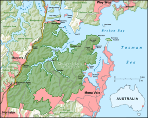
Ku-ring-gai Chase National Park is a special natural area located north of Sydney in New South Wales, Australia. This huge park covers about 14,977 hectares (that's over 37,000 acres!). It's about 25 kilometers (15 miles) north of Sydney's city center. The park stretches from the M1 Pacific Motorway in the west to Pittwater in the east, and from the Hawkesbury River in the north to Mona Vale Road in the south. It even includes Barrenjoey Headland!
Ku-ring-gai Chase is a very popular place for visitors. People love its beautiful views of the Hawkesbury River and Pittwater. The park is also home to many unique plants and animals. You can find important Aboriginal sites and historic European places here too. There are great spots for picnics, boating, and fishing. Plus, many walking tracks let you explore the park's natural beauty. Several small villages like Cottage Point and Bobbin Head are found within the park.
This park was created in 1894, making it the third oldest national park in Australia. The NSW National Parks & Wildlife Service looks after it. In 2006, it was added to the Australian National Heritage List, which means it's a very important place for Australia's history and nature. The park's name, Ku-ring-gai, comes from the Guringai Aboriginal people. They were once thought to be the traditional owners of this land.
Contents
Park's Landscape and Rocks
Ku-ring-gai Chase National Park is part of the Hornsby Plateau. This area is mostly made of sandstone that slopes upwards towards the north. The park sits on a plateau that is usually 150 to 200 meters (about 500 to 650 feet) above sea level.
Millions of years ago, sand, silt, and mud were carried by rivers and settled on flood plains. Over time, these layers formed the rocks we see today, like shales, flagstones, and sandstones. These rocks are part of the Narrabeen Group and can be seen along the waterways and ridges. Higher parts of the park have pink, white, and orange layers of Hawkesbury Sandstone. This sandstone often has small beds of shale within it. The park's stepped landscape is due to these horizontal layers of rock.
You can also find other types of rocks, but they are less common. For example, around Elvina Bay and Lovett Bay, the soil comes from the Narrabeen group of shales. This richer soil allows different plants to grow, like forests of spotted gums and forest oaks. There are also places where old volcanic rocks are found, such as at West Head. These areas have fertile soils that support different plants, like Sydney blue gum trees.
The plateau is cut into separate sections by deep valleys. These include Cowan Creek, Coal and Candle Creek, and Smiths Creek. These valleys are called "rias" because they were once river valleys that became "drowned" when sea levels rose after the last ice age. About 10,000 years ago, as the ice melted, the sea flooded these valleys. This also separated Lion Island and Scotland Island from the mainland.
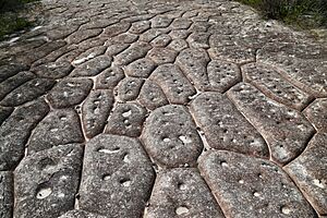
The main rock type is Hawkesbury Sandstone. This rock shapes the land and the plants that grow in the sandy soil. You'll see many sandstone cliffs, rocky outcrops, and worn caves throughout the park. The Aboriginal people used to engrave pictures on these flat sandstone surfaces. You can also find tessellated pavements in the park. These are natural rock formations that look like regular checkered patterns. The highest point in the park is 246 meters (807 feet) at Willunga Trig.
Park's Past: A Look Back in Time
Early Aboriginal History
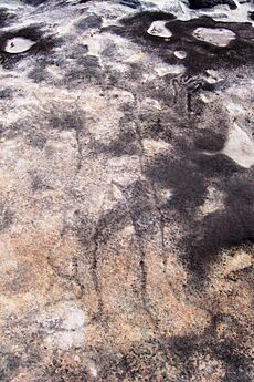
The name Ku-ring-gai refers to Aboriginal people who lived in this area. Not much was written down by early European settlers about these original inhabitants. Sadly, their communities were greatly affected by diseases and conflicts with the new settlers.
The national park holds a lot of evidence that Aboriginal people lived here long before Europeans arrived. There are more than 800 sites in the park that show this. These include rock engravings, cave drawings, old living sites, paintings, and stencils. There are also axe grinding grooves and middens (piles of shells and other food remains). All these sites give us important clues about how the Guringai people lived.
How the Park Was Formed
In 1788, when the first English settlers arrived in Sydney, Governor Phillip explored the area. But he was looking for farmland and wasn't very interested in the steep, rocky landscapes of what is now the park.
Early settlers didn't develop this area much because it was hard to get to and the soil wasn't very good for farming. However, some valuable trees like Red Cedar were heavily cut down. Sawmills were set up in the 1830s to process timber.
A local citizen named Eccleston Du Faur worked for almost 40 years to create a "National Park for North Sydney." Finally, in 1894, about 13,500 hectares (over 33,000 acres) were set aside as Ku-ring-gai Chase. This was meant to be a conservation area. Du Faur was a surveyor and engineer who loved science and nature. When the park was officially created, he became its Managing Trustee. For 10 years, he helped build walking trails and a road to Bobbin Head.
To help pay for the park's upkeep, places like Bobbin Head Inn, picnic shelters, and boat sheds were set up. Picnic areas were also created by reclaiming mud flats between 1910 and 1940.
The area around West Head was privately owned until 1951, when it was added to the park. There were plans in 1927 to build a large community with homes, a country club, and a golf course, but these plans didn't happen because of the Great Depression.
Ku-ring-gai Chase officially became a national park in 1967. It is the third oldest national park in Australia, after Royal National Park. The park has grown to 14,882 hectares (about 36,770 acres) over time. The term "chase" in its name means it was a natural bush area not enclosed by fences. The park is also officially listed as a suburb of Sydney.
The famous TV show Skippy the Bush Kangaroo was filmed in parts of Ku-ring-gai Chase National Park. In January 1994, bushfires caused damage to the park.
Exploring the Park: Places and Facilities
Many of the park's attractions can only be reached by walking tracks. A large part of the park borders the shores of Broken Bay, Pittwater, and Cowan Creek. This makes it a great place to explore by boat. You can also get to the park by train, with stations at Mount Colah, Mount Kuring-gai, Berowra, and Cowan. All the roads in the park are paved, and there's a daily fee to enter by car.
- Bobbin Head is located on Cowan Creek. Here you'll find a marina, picnic areas, a small shop, and a restaurant in the old Bobbin Head Inn. The inn also has an information center. You can walk through mangroves and see Aboriginal engravings in this area.
- Appletree Bay is a picnic spot with a boat ramp, jetty, toilets, picnic tables, and barbecues.
- The Basin is a lagoon with a beach on the west side of Pittwater. It has picnic areas and is the only place in the national park where you can camp. You can get there by walking The Basin Track from West Head Road or by taking a ferry from Palm Beach Wharf.
- West Head is a headland at the park's northeastern tip. There's a lookout here with amazing views of Barrenjoey, Palm Beach, and Broken Bay. Old gun emplacements from World War II can still be found here.
- Barrenjoey Headland is at the northern end of Palm Beach. It's separated from the main park by about 1 kilometer of water. This is where the historic Barrenjoey Head Lighthouse, built in 1880, stands.
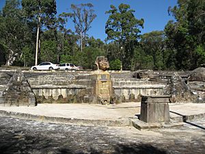
- The Sphinx Memorial is a sandstone monument that remembers the Australian soldiers who died in World War I. A soldier named William Shirley created it in the 1920s, and it took him about a year and a half to finish.
- Cottage Point is Sydney's smallest town and is a heritage conservation area. The Cottage Point Kiosk and Boat Hire, built around 1918, is located here at the entrance to Coal and Candle Creek.
- Jerusalem Bay can be reached by a track that is part of the Great North Walk. This track starts from Cowan railway station. It goes through a creek gorge with temperate rainforest and large turpentine trees. The bay is popular for boating and fishing. Further along the track, you'll find Campbell's Crater, which is a volcanic area with subtropical rainforest plants.
See also
 In Spanish: Parque nacional Ku-ring-gai Chase para niños
 | Chris Smalls |
 | Fred Hampton |
 | Ralph Abernathy |


