
Broken Bay facts for kids
Quick facts for kids Broken Bay |
|
|---|---|

Aerial photograph showing the mouth of Broken Bay as it flows into the Tasman Sea, as seen looking across Sydney's North Shore and Northern Beaches
|
|

Broken Bay
Location in New South Wales
|
|
| Location | Central Coast, New South Wales, Australia |
| Coordinates | 33°34′07″S 151°19′00″E / 33.56861°S 151.31667°E |
| Type | Bay |
| Primary inflows | Hawkesbury River, Brisbane Water, Pittwater |
| Surface area | 17.1 km2 (6.6 sq mi) |
| Average depth | 9.8 m (32 ft) |
| Water volume | 167,615 km3 (40,213 cu mi) |
| Islands | Lion Island |
Broken Bay is a large bay on the coast of New South Wales, Australia. It's about 50 kilometers (31 miles) north of Sydney. This bay is like a big arm of the Tasman Sea that reaches inland. It helps separate the big city of Sydney from the Central Coast region. Broken Bay is also the first major bay you'd find north of Sydney Harbour.
Three main waterways meet here: the Hawkesbury River, Pittwater, and Brisbane Water. From Broken Bay, the water flows straight out into the Tasman Sea. The bay covers an area of about 17.1 square kilometers (6.6 square miles).
Contents
Exploring Broken Bay's Geography
Broken Bay is a special type of bay called a "drowned valley estuary." This means it was formed when sea levels rose and flooded old river valleys.
Main Entrances and Features
The entrance to Broken Bay is between two headlands: Box Head to the north and Barrenjoey Head to the south. The Barrenjoey Lighthouse was built in 1881 to help guide ships safely.
The bay has three main "arms" or sections:
- The Hawkesbury River estuary in the west.
- Pittwater to the south.
- Brisbane Water to the north.
These three arms are all flooded rivers. They were formed a long time ago when the sea level was much lower than it is today.
The Hawkesbury River
The Hawkesbury River starts where the Grose and Nepean Rivers meet. This is at the base of the Blue Mountains.
Pittwater
Pittwater stretches south from Broken Bay. It's known for its calm waters, which makes it a very popular place for sailing. West Head, located west of Barrenjoey Head, marks the boundary between Pittwater and the Hawkesbury River.
Brisbane Water
Brisbane Water is the northern arm of Broken Bay. You'll find the towns of Gosford and Woy Woy along its shores.
Lion Island
Lion Island is located right at the entrance of Broken Bay. It's called Lion Island because from some angles, it looks like a Sphinx. The entire island is a nature reserve. It's home to a colony of fairy penguins.


How Broken Bay Got Its Name
The famous explorer James Cook saw "broken land" north of Port Jackson on May 7, 1770. He decided to name it Broken Bay.
However, there has been some discussion about whether the place Cook saw is the same as the Broken Bay we know today. For example, Matthew Flinders, another explorer, wrote that "The colonists have called this place Broken Bay, but it is not what was so named by Captain Cook."
Some historians believe that Cook actually passed the modern Broken Bay at night. They think he was referring to the area around Narrabeen Lagoon when he wrote about "Broken Bay."
Regardless of what Cook saw, Governor Phillip was the first European to explore the current Broken Bay. He did this in a small boat from the ship Sirius on March 2, 1788.
A Submarine Mystery
In 2005, a filmmaker named Damien Lay claimed that the wreckage of a Japanese midget submarine, called M-24, was buried under sand near Lion Island. This submarine was involved in an event in Sydney Harbour in 1942 and disappeared afterward. Lay believed he found copper wiring that matched what was used in these submarines.
However, after sonar scans were done by the New South Wales Heritage Office, no trace of the submarine was found at that spot.
Later, the M-24 submarine was actually found about 13 kilometers (8 miles) south of Broken Bay. It was about 5 kilometers (3 miles) off Bungan Head. This discovery showed that the submarine had moved north towards Broken Bay, instead of staying south near Sydney Harbour.
Images for kids
-
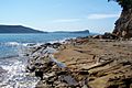
Broken Bay from Flint and Steel Beach
-
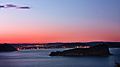
Lion Island with the Central Coast in the background
-
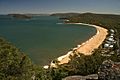
Pearl Beach with Lion Island in the middleground and Pittwater in the background
-
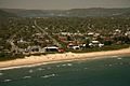
Umina Beach on the northern side of Broken Bay


