Nepean River facts for kids
Quick facts for kids Nepean River |
|
|---|---|

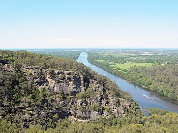
Nepean River, Looking north towards Penrith, 2006
|
|
| Native name | Dharug Dalang: Durrubbin Yandhai |
| Other name(s) | Cowpasture River, Mittagong River, London River |
| Country | Australia |
| State | New South Wales |
| Region | Sydney Basin (IBRA), Southern Highlands, Macarthur, Greater Western Sydney |
| District | Wingecarribee, Wollondilly, Camden, Penrith, Hawkesbury |
| City | Penrith |
| Physical characteristics | |
| Main source | Mittagong Range near Robertson 766 m (2,513 ft) 34°33′59″S 150°36′01″E / 34.566452°S 150.600363°E |
| River mouth | confluence with the Grose River to form the Hawkesbury River near Yarramundi 2 m (6 ft 7 in) 33°36′34″S 150°42′00″E / 33.609446°S 150.699969°E |
| Length | 178 km (111 mi) |
| Basin features | |
| River system | Hawkesbury-Nepean catchment |
| Tributaries |
|
| National park | Blue Mountains National Park |
The Nepean River is a big river in New South Wales, Australia. It flows through the south-west and west of Sydney. The local Aboriginal people, the Darug, call it Yandhai.
The Nepean River and the Hawkesbury River together almost wrap around the city of Sydney. The river starts near Robertson, about 100 km south of Sydney. It flows north into the Nepean Reservoir, which holds drinking water for Sydney.
After the dam, the river forms the western edge of Sydney. It flows past towns like Camden and the city of Penrith. South of Penrith, it goes through the Nepean Gorge. Near Wallacia, the Warragamba River joins it. North of Penrith, near Yarramundi, the Nepean River meets the Grose River and changes its name to the Hawkesbury River.
Contents
How People Have Changed the River
The Nepean River gives water to Sydney's five million people. It also helps farmers grow crops. But because so many people use the water and more buildings are being built, the river is under a lot of stress.
Dams and Weirs
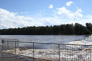
There are eleven weirs (small dams) on the Nepean River. These weirs control how the water flows. They have turned parts of the river into a series of lakes instead of a freely flowing river. Dams in the Upper Nepean area also affect the river.
The Wallacia Weir was first built from wood for a flour mill. Later, a concrete weir was built. This weir is at the start of the Nepean Gorge. This gorge was carved out as the Blue Mountains slowly rose over millions of years.
In the 1950s, the Warragamba Dam was built across the Warragamba River. This river is the Nepean's main branch. The dam stopped most of the water from flowing into the Nepean. This water was sent to Sydney instead. This made the Nepean River much smaller than it used to be.
Impact on Fish and Nature
These dams and weirs have had a big effect on the river's wildlife. They block native fish, like Australian bass, from moving to their old homes. They also reduce floods that fish need to lay their eggs. Even so, the Hawkesbury/Nepean River is still a popular place for fishing for wild bass.
The beautiful banks of the Nepean River are a natural home for local plants and animals. They are also a peaceful place for people to relax. At Emu Plains, the western bank is used for outdoor plays in summer. The eastern bank at Penrith has barbecue areas and playgrounds for kids. There's also a long path for walks along the river. The Nepean Rowing Club is also located on the eastern bank.
River History
Aboriginal History
Aboriginal people used the Nepean River regularly for thousands of years. Their fish traps could be seen at Yarramundi before sand and gravel mining changed the river. Early European explorers like Charles Darwin and Watkin Tench saw Aboriginal people fishing with spears, lines, and nets. The people of the Nepean area also traded with groups from the western plains. They used a route that later became Bells Line of Road.
Near Penrith, many Aboriginal stone tools have been found. These tools were in gravel from the Nepean River. Scientists have used special dating methods to find out that some of these tools are 40,000 to 50,000 years old. This shows that people lived in this area a very long time ago. Many more tools from the last 5,000 years have also been found.
European Settlement
In 1788, the British started a colony in Sydney. Governor Arthur Phillip explored the coast north of Sydney. He named the Hawkesbury River after Lord Hawkesbury.
At the same time, Lieutenant Watkin Tench walked inland, west of Sydney. About 60 km from Sydney, he found a large river at the foot of the Blue Mountains. He named it the Nepean River after Evan Nepean, a friend of Governor Phillip. It took about three years for them to realize that the Nepean River flowed into the Hawkesbury River.
The Nepean River was also a key place during the Hawkesbury and Nepean Wars. These were conflicts between the British and local Aboriginal groups in the late 1700s and early 1800s.
In the 1820s, a famous early settler named Sir John Jamison built a large house called Regentville near Penrith. It overlooked the river. The house was destroyed by fire in the 1860s. Jamison was important for farming and politics in early Australia.
River Crossings
Even though the Nepean River forms the western edge of Sydney, there are not many bridges that cross it. Here are some of the main crossings:
| Crossing name | Right bank location | Left bank location | What it's used for | Image |
|---|---|---|---|---|
| Yarramundi Bridge | Yarramundi | Agnes Banks | Carries the Springwood Road | |
| Victoria Railway Bridge | Emu Plains | Penrith | Built in 1907, this bridge carries the train tracks for the Main Western railway line. |  |
| Victoria Bridge | Built in 1867, this bridge first carried trains and horse-drawn vehicles. Now it carries the Great Western Highway. About 24,500 vehicles use it every day. |  |
||
| Yandhai Nepean Crossing | Built in 2018, this bridge is for people walking and riding bikes. | |||
| Regentville Bridge | Leonay | Regentville | Carries the M4 Western Motorway. About 55,000 vehicles use it daily. | |
| Wallacia | Carries the Silverdale Road | |||
| Brownlow Hill | Carries the Cobbitty Road | |||
| Camden | Kirkham | Carries the Macquarie Grove Road, near the Camden Airport | ||
| Cowpasture Bridge | Elderslie | Carries road traffic on the Camden-Narellan Road | ||
| Macarthur Bridge | Spring Farm | Opened in 1973, this bridge is 1.12 km long and carries the Camden Valley Way. |  |
|
| Menangle | Menangle Park | Carries road traffic on the Menangle Road | ||
| The Menangle Viaduct | Built in 1864, this is the oldest surviving rail bridge in New South Wales. It carries the Southern Highlands railway line. |  |
||
| Menangle | Carries road traffic on the Hume Highway | |||
| Douglas Park Bridge | Douglas Park | These are two concrete bridges that carry road traffic on the Hume Highway. |  |
|
| Carries road traffic on the Douglas Park Drive. | ||||
| Maldon Bridge | Maldon | Built in 1980, this concrete bridge carries the Picton Road. | ||
| Maldon Suspension Bridge | Built in 1903, this wooden suspension bridge used to carry road traffic. It is now closed. |  |
||
| Pheasants Nest Bridge | Pheasants Nest | Carries road traffic on the Hume Highway | ||
Floods in the Nepean Area

The first flood recorded was in 1795. More floods happened in 1799, 1806, and 1809. In 1810, after many big floods on the Hawkesbury, Governor Macquarie created five towns. He wanted people to build their homes on higher ground to avoid floods.
The most damaging flood happened in June 1867. The Nepean River was estimated to be 13.4 meters higher than usual. This flood washed away parts of the new Victoria Bridge. Towns like Emu Plains, Castlereagh, and parts of Penrith were underwater. Many homes were swept into the river. People had to find safety in public buildings like the hospital. A flood like the one in 1867 today would cause huge damage, costing about A$1.4 billion.
Other big floods happened in July 1900 and March 1914. Again, many streets flooded, and homes and property were lost along the river. In 1974, there was another significant flood caused by a La Niña weather event.
 | Shirley Ann Jackson |
 | Garett Morgan |
 | J. Ernest Wilkins Jr. |
 | Elijah McCoy |

