
Lane Cove River facts for kids
Quick facts for kids Lane Cove River |
|
|---|---|

Lane Cove River at night, showing the Fig Tree Bridge
|
|

NASA satellite view of Greater Metropolitan Sydney, with the location of the mouth of the Lane Cove River as it flows into the Parramatta River, as marked
|
|
| Country | Australia |
| State | New South Wales |
| Region | Sydney basin (IBRA) |
| LGAs | Ku-ring-gai, Ryde, Willoughby, Lane Cove, Hunters Hill, Hornsby |
| Physical characteristics | |
| Main source | Thornleigh Oval Thornleigh 33°44′5.9994″S 151°5′20.3994″E / 33.734999833°S 151.088999833°E |
| River mouth | Parramatta River Greenwich Point and Woolwich 33°50′32.3998″S 151°10′38.3988″E / 33.842333278°S 151.177333000°E |
| Length | 15 km (9.3 mi) |
| Basin features | |
| River system | Parramatta River catchment, Sydney Basin |
| Tributaries |
|
The Lane Cove River is a beautiful river in Sydney, New South Wales, Australia. It's like a long, winding arm of Sydney Harbour. The river flows through a lovely bushland valley. It eventually joins the Parramatta River near Greenwich and Woolwich. Together, they become part of Sydney Harbour. The river also acts as a natural border, separating parts of Sydney's North Shore.
Contents
About the Lane Cove River
The Lane Cove River starts near Thornleigh. It flows south for about 15 kilometres (9.3 mi) (about 9 miles). The area of land that drains into the river is about 95.4 square kilometres (36.8 sq mi) (about 37 square miles).
River Sections and Their Features
The upper part of the river flows through a narrow, forested valley. This valley was carved out of the North Shore Plateau over many years. In the early 1800s, people used to cut down trees here at a place called Fiddens Wharf.
Further downstream, a wall called a weir holds back the water. This weir is just above Fullers Bridge. Many parts of the valley are still covered in forests. These areas are protected within the Lane Cove National Park. This park covers 598 hectares (1,480 acres) (about 1,478 acres) and is a special place for nature.
The lower part of the Lane Cove River, below the weir, is affected by the ocean's tides. This means the water level goes up and down with the tides. This part of the river flows into Sydney Harbour. You can find many mangrove trees growing along the shores here.
Where the River Meets Other Creeks
The Lane Cove River meets Scout Creek inside the Lane Cove National Park near Cheltenham. As it continues, it is joined by Devlins Creek near North Epping. Then, Terrys Creek flows into it near Macquarie Park.
As the river flows past Killara and Lindfield, it gets wider. It keeps flowing south through the national park. Finally, it reaches its mouth between Greenwich Point and Woolwich. Here, it merges with the Parramatta River and becomes part of Port Jackson, which is what most people call Sydney Harbour.
Devlins Creek was named after the Devlin family. They lived in a historic house called Willandra in Ryde.
Lane Cove National Park
The area around the Lane Cove River is mostly a national park. It's called Lane Cove National Park and is about 1 kilometre (0.62 mi) (0.6 miles) wide. This park is very important for nature. It's even listed on the Australian Register of the National Estate.
The park is home to a special community of fungi. Some of these fungi species are so rare that scientists haven't even classified them all yet!
There's also a popular place to stay called Lane Cove River Tourist Park. It's a caravan park and campground located on the western side of the valley, high above the river.
Walking Trails and History
The Lane Cove River area has many old trails and paths. Some of these paths were used long ago when people were logging trees. Today, these trails are great for walking and exploring.
The Great North Walk
Some of the old trails are now part of the Great North Walk. This is a very long walking trail that goes all the way from Sydney to Newcastle! The Great North Walk follows the Lane Cove River between Boronia Avenue in Hunters Hill and Thornleigh Oval in Thornleigh.
Near Thornleigh Oval, the trail uses a path called Lorna Pass. This path was built in the 1930s during a tough time called the Depression. Building the path helped provide jobs for people. It was named after Lorna Brand, who helped raise money for the work. Another trail, the Lane Cove Valley Walk, goes from Thornleigh to Lindfield.
Fairyland Picnic Area
From 1913 until the early 1970s, a family named Swan ran a popular picnic spot called Fairyland. It was right on the banks of the river, upstream from Epping Road.
Fairyland started as a market garden, but the family saw that it could be a fun place for picnics. They added many things for visitors, like a footbridge, BBQ areas, a boat swing, a "razzle dazzle" ride, a shelter, a dance hall, and a wharf. Today, Fairyland has returned to nature and is part of the Lane Cove National Park. The Great North Walk even passes through this historic area.

Important Historical Sites
Curzon Park and Hall
Harry Smith was a businessman who owned land in the Marsfield area. He created a picnic spot on his property called Curzon Park. This park was next to the Lane Cove River and had eighty acres of bushland.
The picnic area is now part of nature again. However, you can still see some old stone steps at the top of the cliff above the river. It's very likely that Harry Smith had these steps built so people could easily get to his picnic area. News from 1899 also mentions stone steps leading down to the picnic spot.
Harry Smith also had a quarry nearby, where he got stone to build his large house, Curzon Hall. He built Curzon Hall around 1899. It's located where Balaclava and Agincourt Roads meet. The name Curzon came from his wife, Isabella Curzon Webb.
In 1922, a group called the Vincentian Fathers bought the building and turned it into a Catholic school for priests. In 1983, it became a place for events and parties. Curzon Hall is listed on the New South Wales Heritage Register as an important historical site. Harry Smith was known for being kind and generous. He let people use his picnic area for free and even built the public school in Marsfield. He passed away in 1913.
Bridges Over the River
Four main bridges cross the Lane Cove River, connecting different suburbs:
- De Burghs Bridge is on the A3 road. It connects North Ryde and West Pymble.
- Fullers Bridge is on the A38 road. It connects Chatswood and North Ryde.
- The Epping Road Bridge carries Epping Road traffic on its sides. The M2 Hills Motorway runs in the middle. Both connect Lane Cove to Ryde.
- Fig Tree Bridge is on Burns Bay Road. It connects Lane Cove West and Hunters Hill.
Gallery
-
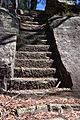
Steps that provided access to Harry Smith's picnic area
-
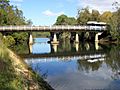
Lane Cove River at Fullers Bridge, Chatswood West.
-
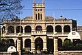
Curzon Hall
-
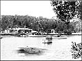
Archival photo of Fairyland
-
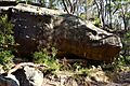
Formation known as Whale Rock outside Cheltenham
-
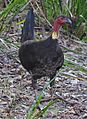
An Australian Brushturkey in the national park
steps_possibly_Harry_Smiths-1.jpg)

Curzon_Hall.jpg)

Whale_Rock_formation.jpg)
Brushturkey_Lane_Cove_River_056a.jpg)
See also
 In Spanish: Río Lane Cove para niños
