Marsfield, New South Wales facts for kids
Quick facts for kids MarsfieldSydney, New South Wales |
|||||||||||||||
|---|---|---|---|---|---|---|---|---|---|---|---|---|---|---|---|

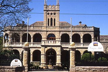
Curzon Hall on Agincourt Road, built in 1898
|
|||||||||||||||
| Postcode(s) | 2122 | ||||||||||||||
| Elevation | 86 m (282 ft) | ||||||||||||||
| Area | 3.86 km2 (1.5 sq mi) | ||||||||||||||
| Location | 16 km (10 mi) north-west of Sydney CBD | ||||||||||||||
| LGA(s) | City of Ryde | ||||||||||||||
| State electorate(s) | Ryde | ||||||||||||||
| Federal Division(s) | Bennelong | ||||||||||||||
|
|||||||||||||||
Marsfield is a suburb located in the northern part of Sydney, in New South Wales, Australia. It's about 16 kilometres north-west of the main city area, known as the Sydney CBD. Marsfield is part of the City of Ryde local government area.
This suburb is well-known because it's close to many important science and education places. These include the CSIRO, Macquarie University, and the Macquarie Park Business Park.
Contents
History of Marsfield
The name Marsfield comes from "Field of Mars." This was the original name given to the area in 1792 by Governor Arthur Phillip. He named it during the early days of British settlement in Australia.
Aboriginal History of Wallumatta
Before European settlement, the land between the Parramatta River and Lane Cove River was known by its Aboriginal name, Wallumatta. This name is still used today for a local park, the Wallumatta Nature Reserve. You can find it at the corner of Twin and Cressy Roads in North Ryde.
European Settlement and Land Grants
In 1792, Governor Phillip started giving out pieces of land to Royal Marines. He called this area the "Field of Mars." This name likely came from the Roman Field of Mars, which was a place for military training.
Later, Marsfield became part of the larger North Ryde area. Many people still think of Marsfield as part of North Ryde. In 1835, the area was officially named the "Field of Mars Parish."
Land Sales and New Farms
In 1874, the government decided to sell the "Field of Mars Common" land. They wanted to divide it into smaller farms for people to settle. The money from these sales helped pay for new bridges over the Parramatta River.
The land was split into small farms, ranging from about 0.4 to 1.6 hectares. These farms were put up for sale in different stages, starting in 1885.
Streets Named After Battles
Many streets in Marsfield and nearby suburbs like Eastwood and Macquarie Park are named after famous historical battles. For example, you'll find streets like Agincourt Road, Alma Road, Balaclava Road, and Waterloo Road.
Local Government and Curzon Hall
In 1894, Marsfield formed its own local government, called the "Municipality of Marsfield." It separated from the Ryde Municipality.
A grand building called Curzon Hall was built in the 1890s. It was built by Harry Smith and named after his wife, Isabella Curzon-Smith. In 1921, the Society of Saint Vincent de Paul bought the house and used it as St Joseph's Seminary. Today, Curzon Hall is a popular place for events and functions.
Green Belt Changes
Until the 1950s, large parts of Marsfield and North Ryde were part of a "Green Belt." This rule stopped houses from being built on land smaller than 2 hectares.
In 1959, the Green Belt rules changed, and 688 hectares of land were opened up for building. The very last of the Green Belt land was released in 1969. This land was used to build the Macquarie Shopping Centre and Macquarie University.
Marsfield Boundaries
Marsfield has clear boundaries around it. To the north, it's bordered by the Lane Cove River, the Macquarie University Sports Fields, and several roads like Talavera Road and Culloden Road.
To the east, you'll find Epping Road, Shrimptons Creek, and Kent Road. In the south, Bridge Road and Abuklea Road mark the boundary. Finally, to the west, Marsfield is bordered by Terrys Creek.
Important Places and Buildings
Marsfield is home to several important landmarks and institutions:
- Curzon Hall: Located at 53 Agincourt Road, this large, castle-like building was built in 1898. It has a unique neo-Romanesque style and is now used as a restaurant and event venue.
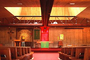
- St Anthony's Catholic Church: Found at 54 Agincourt Road, this church has a modern design. It was built in 1968 by Italian architect Enrico Taglietti.
- Epping Boys High School: A well-known school for boys.
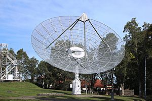
- CSIRO: This is Australia's national science agency. Marsfield is home to their Radio Physics Laboratory and the Data61 ICT Centre.
- Australia Telescope National Facility: The main office for this important astronomy facility is in Marsfield.
- Anglo-Australian Observatory: This observatory also has its headquarters here.
- TG Millner Field: A sports ground in the area.
Housing in Marsfield
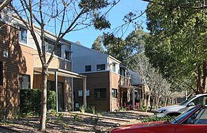
Marsfield is a green suburb with different types of homes. On the higher parts, you can find large, modern houses that sometimes have views of the city. Closer to South Turramurra and Epping, there are more townhouses and apartments.
Many people living in Marsfield are students who attend Macquarie University. In 2021, about 46.6% of homes were semi-detached (like townhouses), 31.6% were separate houses, and 21.5% were flats or apartments. Most homes (65.8%) were family households.
Getting Around: Public Transport
Marsfield has good public transport options, mainly buses and a train station.
- Buses: Several bus routes serve Marsfield. For example, routes 292 and 293 travel from the city through Lane Cove and end in Busaco Road. Other routes, like 288 and 291, go along Epping Road to Epping train station.
- Train: The Macquarie University railway station is located on Herring Road. It's conveniently placed between Macquarie University and the Macquarie shopping centre.
Marsfield Population and People
In 2021, the population of Marsfield was about 12,492 people. Here's a look at who lives there:
- Age: Marsfield residents are slightly younger than the average for Australia. The median age was 39 years. Children aged 0–14 made up 15.7% of the population.
- Background: About 43.2% of people in Marsfield were born in Australia. Many residents come from other countries, with the most common birthplaces being China (14.3%), India (4.5%), and Hong Kong (4.4%).
- Languages: While 42.8% of people spoke only English at home, many other languages are also spoken. The most common non-English languages are Mandarin (15.9%) and Cantonese (9.6%).
- Religion: In terms of religion, the most common response was "No Religion" (39.1%). Other common religions included Catholic (20.1%) and Anglican (6.3%).
- Income: The average weekly household income in Marsfield was $1,943, which is a bit higher than the national average.
See also
 In Spanish: Marsfield para niños
 | Tommie Smith |
 | Simone Manuel |
 | Shani Davis |
 | Simone Biles |
 | Alice Coachman |


