
North Epping, New South Wales facts for kids
Quick facts for kids North EppingSydney, New South Wales |
|||||||||||||||
|---|---|---|---|---|---|---|---|---|---|---|---|---|---|---|---|

North Epping retail area
|
|||||||||||||||
| Established | 1899 | ||||||||||||||
| Postcode(s) | 2121 | ||||||||||||||
| Elevation | 98 m (322 ft) | ||||||||||||||
| Area | 2.3 km2 (0.9 sq mi) | ||||||||||||||
| Location | 19 km (12 mi) from Sydney CBD | ||||||||||||||
| LGA(s) | Hornsby Shire | ||||||||||||||
| State electorate(s) | Epping | ||||||||||||||
| Federal Division(s) | Bennelong | ||||||||||||||
|
|||||||||||||||
North Epping is a suburb located in Sydney, New South Wales, Australia. It's about 19 kilometres north-west of the main city centre. This area is part of the Hornsby Shire local government area.
North Epping is known for being a very green suburb. It is surrounded by the beautiful bushland of the Lane Cove National Park. This park makes North Epping feel a bit separate from the rest of Hornsby Shire.
Because of its location, North Epping often uses facilities in the nearby suburb of Epping. This includes things like public transport, libraries, and swimming pools.
There are many great walking trails in and around North Epping. The famous Great North Walk passes through here. You can also find a well-known landmark called Whale Rock.
Contents
A Look Back: North Epping's History
First People: Aboriginal Culture
Long ago, the Wallumedegal Aboriginal people lived in this area. Their land was between the Lane Cove River and Parramatta River. They called this region Walumetta.
European Settlement Begins
In 1792, Governor Arthur Phillip started giving out land to soldiers. He called this area the "Field of Mars." This name came from the Roman "Field of Mars," which was a military training ground.
The land that is now Epping and North Epping was part of this "Field of Mars." The name "Epping" comes from a forest in England called Epping Forest.
Over time, the land was used for farms and orchards. After World War II, more homes were built. Areas that were once protected bushland became available for houses in 1948. The North Epping post office opened in 1954, and the public school started in 1960.
Becoming Its Own Suburb
North Epping officially became a separate suburb from Epping on December 1, 1995.
Council Changes: Hornsby and Parramatta
In 2016, the suburb of Epping joined the City of Parramatta council. This meant North Epping became a bit like an island for Hornsby Shire. It's still part of Hornsby, but it's surrounded by areas that are now part of Parramatta.
Shopping and Community Life
North Epping has a small shopping area. You can find it at the corner of Roma Street and Malton Road. It has several shops, cafes, and restaurants.
The suburb also has a school called Epping North Public School. There are many parks and places for community gatherings, which makes it a friendly place to live.
Getting Around North Epping
The M2 Hills Motorway runs along the southern edge of North Epping. This motorway helps people travel to the Sydney central business district.
North Epping is connected to Epping by one main road, Norfolk Road. This road goes south towards Epping Road. Most of North Epping is covered by the Busways route 295. This bus route goes in a loop around the suburb.
Who Lives in North Epping?
According to the 2021 census, North Epping had 4,657 people living there.
- Age: The average age of people in North Epping was 44 years old. About 19% of the population were children aged 0–14 years.
- Background: Most people (62.1%) were born in Australia. Other common birthplaces included China, India, England, Hong Kong, and South Korea.
- Languages: English was the main language spoken at home by 65% of people. Other languages included Mandarin, Cantonese, and Korean.
- Income: North Epping is a well-off area. The average weekly household income was higher than the national average.
- Homes: Most homes (92%) in North Epping are separate houses.
Places of Worship
- All Saints Anglican Church (295 Malton Rd)
- Northern District Chinese Christian Church Sydney (41 Boundary Road)
Images for kids
-
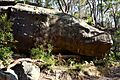
Whale Rock formation, on the Boundary Road Fire Trail
-
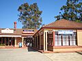
North Epping shops
Whale_Rock_formation.jpg)

