
Thornleigh, New South Wales facts for kids
Quick facts for kids ThornleighSydney, New South Wales |
|||||||||||||||
|---|---|---|---|---|---|---|---|---|---|---|---|---|---|---|---|
Federation_home_Station_Street_Thornleigh.jpg)
Federation style home, Station Street
|
|||||||||||||||
| Population | 8,898 (2021 census) | ||||||||||||||
| • Density | 2,220/km2 (5,700/sq mi) | ||||||||||||||
| Established | 1830s | ||||||||||||||
| Postcode(s) | 2120 | ||||||||||||||
| Elevation | 170 m (558 ft) | ||||||||||||||
| Area | 4 km2 (1.5 sq mi) | ||||||||||||||
| Location | 22 km (14 mi) north-west of Sydney CBD | ||||||||||||||
| LGA(s) | Hornsby Shire | ||||||||||||||
| State electorate(s) |
|
||||||||||||||
| Federal Division(s) | Berowra | ||||||||||||||
|
|||||||||||||||
Federation_house_Thornleigh-2a.jpg)

Thornleigh is a suburb located in the Upper North Shore area of Sydney, New South Wales, Australia. It is about 22 kilometres north-west of the main city centre of Sydney. Thornleigh is part of the Hornsby Shire local government area. The start of the Lane Cove River can be found in Thornleigh.
Contents
Exploring Thornleigh's Landscape
Thornleigh is surrounded by nature. To the north, you'll find Waitara Creek, and to the south, it borders the beautiful Lane Cove National Park. It shares its edges with other suburbs like Normanhurst, Hornsby, Wahroonga, Westleigh, and Pennant Hills.
Views and Green Spaces
Thornleigh offers amazing views, and its land changes a lot, with many homes built among bushland and on hills to capture these sights. The northern parts of the suburb, near Larool Creek and Waitara Creek, are very green and full of plants. You can spot native animals like rainbow lorikeets, kookaburras, cockatoos, and bush turkeys there. For a great lookout, visit Majorie Headen Lookout, which offers views over the Larool and Waitara Creek Valley.
Historic Homes
Near the train station and Comenarra Parkway, you can see some older homes. These include early examples of Federation and Californian Bungalow style houses, which have unique designs from the past.
Thornleigh's Past: A Journey Through Time
Thornleigh's story began long ago with the Kuringai people, who were the original inhabitants of this land. The first European explorers, led by Governor Arthur Phillip, arrived in 1788. Settlers started moving into the area in the 1830s.
How Thornleigh Got Its Name
The name Thornleigh comes from Constable John Thorn. In 1830, John Thorn and another constable named Horne bravely captured some "bushrangers" (outlaws) named Dalton and John MacNamara. As a reward, they were given land in 1838. Horne's land became Hornsby (now Normanhurst), and Thorn's land became Thornleigh.
Farming and Early Life
In the late 1800s, growing fruit, especially orchards, was a big part of life in Thornleigh. People selling land would describe the area as "beautifully situated" with "magnificent orchards" to show how fertile the soil was. One important orchard grower was Patrick Michael Duffy, and Duffy Avenue is named after him.
The Railway Arrives
In 1884, a special railway line was built from Strathfield to Hornsby. A 1.2-kilometre branch line was added to reach a quarry near Thornleigh. This line even had a "zig zag" section, which helped trains climb steep hills.
Thornleigh railway station officially opened on September 17, 1886. This was a big deal because it allowed local farmers to send their fruit, especially citrus, to city markets. Thornleigh fruit was even sent as far as Vancouver and San Francisco! The Thornleigh Post Office also opened a couple of years later, in 1888.
Changes Over Time
The Thornleigh School of Arts, a community building, opened in 1890. Sadly, it was pulled down in 1980, along with other old buildings, to make way for new shops and businesses. To make up for this, the Thornleigh Community Centre was built for everyone to use.
In 1901, the National Brickworks started making bricks in Thornleigh. Later, in 1913, one of the biggest malt works in the Southern Hemisphere was built here by WG Chilvers. That's why Chilvers Road is named after him! Another street, Norman Avenue, is named after a famous Australian engineer, Norman Selfe.
Lorna Pass: A Path with a Story
During the Great Depression in the 1930s, many people didn't have jobs. A local woman named Lorna Brandt helped raise money to build a walking track near the Lane Cove River. This project gave people work and helped the community.
The track starts at Thornleigh Oval and winds through the bush towards the Lane Cove River. It's now known as Lorna Pass, in memory of Lorna Brandt. It's also part of the Great North Walk, a very long walking trail that goes all the way from Sydney to Newcastle. Along the path, you can even see rock carvings made by the workers who built it.
A University That Almost Was
In the early 1960s, there were talks about building a new university in Thornleigh. It was thought to be a good central spot. However, the university was eventually built in Macquarie Park and is now known as Macquarie University.
Getting Around Thornleigh
Thornleigh has good transport links, making it easy to get around.
Train Services
Thornleigh railway station is on the Northern Line of the Sydney Trains network. This means you can catch trains to many parts of Sydney.
Roads and Buses
Pennant Hills Road is a major road that runs through Thornleigh and is part of Australia's National Highway system. The Esplanade and Comenarra Parkway are also important roads that connect Thornleigh to nearby suburbs.
There are also several bus services run by CDC NSW Upper North Shore, including:
- 587 - Hornsby to Westleigh (via Waitara and Normanhurst)
- 588 - Hornsby to Normanhurst West (via Normanhurst)
- 589 - Hornsby to Sydney Adventist Hospital (via Waitara, Normanhurst, Woodlands Estate, and Thornleigh)
- 600 - Hornsby to Parramatta (via Waitara and Normanhurst)
Shopping and Businesses
Thornleigh has a mix of industrial and commercial areas.
Thornleigh Marketplace
Opened in 2005, Thornleigh Marketplace is a popular shopping spot. It has a Woolworths supermarket and many other shops like a post office, butchers, hair salons, a pharmacy, a newsagency, a gym, and cafes.
You can also find shops and restaurants around Thornleigh railway station and in nearby Pennant Hills. The large hardware store Bunnings Warehouse has a store next to Pennant Hills Road. Interestingly, the American fast-food chain McDonald's has its Australian headquarters and a main store right here in Thornleigh!
Places of Worship
Thornleigh is home to several churches:
- St George Maronite Catholic Church
- Thornleigh Community Baptist Church
- Thornleigh Hillcrest Uniting Church
- Chinese Australian Baptist Church
- Northridge Vineyard Church
St_George_Maronite_Catholic_Church_Thornleigh_135.jpg)
Schools in Thornleigh
Thornleigh has schools for younger students:
- Thornleigh West Public School is a primary school for Kindergarten to Year 6.
- Normanhurst West Public School (Kindergarten to Year 6) is located nearby at the corner of Sefton and Dartford Road.
The original Thornleigh Public and Infants Schools closed in 1989 and were later pulled down. A Bunnings hardware store now stands where they once were.
Who Lives in Thornleigh?
According to the 2021 census, Thornleigh had 8,898 people living there.
Age Groups
The average age of people in Thornleigh was 40 years old, which is similar to the rest of Australia. About 20.9% of the population were children under 15 years old.
Backgrounds and Languages
Most people in Thornleigh (61.8%) were born in Australia. Other common birthplaces included China, India, England, South Korea, and the Philippines. English is the main language spoken at home (66.0%), but many other languages are also spoken, such as Mandarin, Cantonese, Korean, Arabic, and Hindi.
Beliefs
When asked about religion, the most common answers were: No Religion (38.0%), Catholic (21.3%), Anglican (12.2%), and Hinduism (4.3%).
Sports and Fun in Thornleigh
Thornleigh offers many ways to stay active and have fun!
Local Sports Clubs
The Thornleigh Sport and Recreation Club has teams for baseball, basketball, cricket, netball, soccer, and softball. The local soccer club, Thunder FC, has teams for all ages, from Under 6s to adults, and they play at Oakleigh Oval and Ruddock Park.
The Brickpit Park
The Brickpit Park is a popular spot, especially for basketball, as it's home to the Hornsby-Ku-Ring-Gai Basketball Association. Many schools in the area use it for sports too. At the Brickpit Park, you'll also find The Thornleigh Golf Centre, which has driving ranges and mini-golf courses. There's also a skateboarding area and other places for relaxing activities.
Squash Centre
If you like squash, the Thornleigh Squash Centre has 9 courts with glass backs, which are great for watching the game.
Images for kids
-
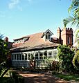
Federation house with tower and battlements
-
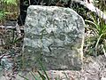
Old stone sign on Lorna Pass, near the Lane Cove River
