Sackville, New South Wales facts for kids
Quick facts for kids SackvilleSydney, New South Wales |
|||||||||||||||
|---|---|---|---|---|---|---|---|---|---|---|---|---|---|---|---|

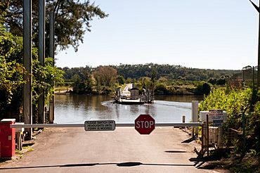
Ferry crossing in 2012. Looking toward North Sackville.
|
|||||||||||||||
| Population | 298 (2016 census) | ||||||||||||||
| Postcode(s) | 2756 | ||||||||||||||
| Elevation | 7 m (23 ft) | ||||||||||||||
| Location | 70 km (43 mi) from Sydney CBD | ||||||||||||||
| LGA(s) | City of Hawkesbury | ||||||||||||||
| County | Cumberland | ||||||||||||||
| Parish | Cornelia | ||||||||||||||
| State electorate(s) | Hawkesbury | ||||||||||||||
| Federal Division(s) | Macquarie | ||||||||||||||
|
|||||||||||||||
Sackville (also known as Doorumbolooa) is a small town near Sydney, in New South Wales, Australia. It is part of the City of Hawkesbury region. In 2016, about 298 people lived there.
Sackville is located right on the Hawkesbury River. It is home to the Sackville Ferry, a special boat that carries cars across the river to North Sackville. This area also has five places that are listed as National Heritage sites. These include three old houses, St Thomas' Anglican Church, and the Sackville Cemetery, which started in 1828.
Sackville is surrounded by other towns. To the south are Ebenezer and Wilberforce. East Kurrajong is to the east, and Lower Portland is to the north.
Contents
A Look Back: Sackville's History
Sackville is built on the rich, fertile soil near the Hawkesbury River. This area was perfect for farming because it had plenty of fresh water. The river also provided an easy way to travel to Sydney.
European settlers first came to Sackville in 1803 to start farms. The settlement was named after Viscount Sackville. He was an important British official from 1775 to 1782.
Governor Arthur Phillip first met the local Aboriginal people here in July 1789. He was traveling along the Hawkesbury River by boat.
By 1928, the number of Aboriginal people in the area had become much smaller. This was due to many conflicts with European settlers. The remaining Aboriginal families had to group together to survive. Important families included the Clark(e)s, Dillons, Everingham-Saunders, Barber-Morleys, and Newmans. By 1862, the Aboriginal groups in Sackville and La Perouse were the largest left in the Sydney area. You can still see painted hands in a cave and rock carvings. These show that Aboriginal people lived here for a very long time.
In 1880, a researcher named Robert Mathews wrote down the language of the people in Sackville. He identified it as Darkiñung. This name is still used today. In 1829, a list of Aboriginal place names on the Hawkesbury was made by Reverend John McGarvie. Another list of Indigenous words was recorded by James Tuckerman in Sackville.
Getting Around: Transport
In 1864, a railway line opened from Sydney to Windsor. This made it easier to send farm goods by train. However, by the 1880s, the river between Sackville and Windsor became too shallow. This meant that large ships could only travel as far as Sackville.
Boats like the SS Hawkesbury (from the 1880s) and the SS Narara (from 1900 to 1909) connected Sackville to Sydney by river. Later, two passenger steamers, Empress and Surprise, made daily trips. These boats were very busy during the fruit season. One boat, The Lady Hawkesbury, even broke the cables of the Sackville Ferry once!
The Sackville Ferry is one of five car ferries on the Hawkesbury River. It is believed to have started operating in the early 1870s. It was privately owned and used to carry school children and fresh farm produce. The ferry helped move goods to the Sydney Markets. In July 1883, the government approved a new ferry (called a punt) for Mitchell Wharf in Sackville.
Sackville Road is the main road that leads to Sackville from Windsor. It continues on the other side of the river in North Sackville. This main road cuts through Sackville. To the east, Tizzana Road follows the river to St Thomas Church and then to Ebenezer. West Portland Road runs west from Sackville Road. It then turns sharply north towards Lilburndale Homestead and Roberts Creek.
Special Places: Heritage Listings
Sackville has five sites that are listed as important heritage places.
St. Thomas Cemetery
St. Thomas Cemetery is at the northern end of Sackville, where Tizzana Road turns. This was also the location of the first Anglican church. It shows the history of the early settlers and their families. An Aboriginal woman named Martha Everingham (born Hobbs) was buried here in 1926. She was said to be one of the original Hawkesbury Aboriginal people. The oldest gravestone is from February 1, 1828. It marks the burial of Grace Turnbull, who was 33 years old. The old Georgian headstones are very important because they are rare examples from that time.
St Thomas' Anglican Church
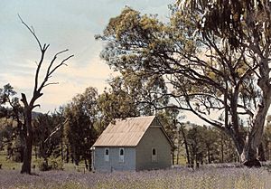
The first church building was at the cemetery, but a big flood in 1867 washed it away. The church was rebuilt in the 1870s, further up the hill on the other side of Tizzana Road. St Thomas' is a good example of a Victorian Gothic church. It has a steep roof, a bell tower, and pointed arched windows. The church had a fire in 1959 and needed a lot of repairs.
Lilburndale House
Lilburndale is an old house located at 413 West Portland Road. It marks the upper part of Sackville. The house was built around 1850 by George-Smith Hall. His grandparents, George and Mary-Ann Hall, were early settlers and owned the land. George Hall senior also helped build Ebenezer Church. He sadly drowned in the Hawkesbury River in 1840. In 2021, Lilburndale started being used as a place for weddings.
Old House on Tizzana Road
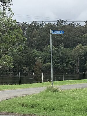
This house is on the hill above Madeleine Place, across from the Ski Gardens at 742 Tizzana Road. There are old stories that say this house was a stop for transporting prisoners by river. It's believed that there might be cells under the front part of the house. The house might be from around 1940. It is not as old as Mr James Holmes' house from 1885, which is on the hill near Churchill's Wharf.
House and Barn on Sackville Road
This property is located at 888 Sackville Road. The house is a "very good example" of a large bungalow from between the two World Wars. It has different colored bricks and plaster, wide gables, and leadlight windows. The property also has a tall slab barn. This type of barn is common in the Hawkesbury area.
Fun Things to Do
- The straight part of the river at the northern end of Tizzana Road is popular for water skiing. It is home to the Sackville Ski Gardens and a caravan park.
- Daragyle Ski Park is another place for skiing.
- The famous racing driver, Gelignite Jack Murray, once water skied at Sackville behind a sea plane! He had a small hut near Addy's Creek. He used the boat sheds and ramp at Sackville Ski Gardens.
- The first Australian woman to compete in the World water skiing titles in 1953 learned to ski at Sackville. Mrs Ray Leighton said her husband taught her. He learned from photographer Reg Johnson, who helped bring water skiing to Australia. Leighton said they started skiing at Sackville because it's "the best spot."
 | Sharif Bey |
 | Hale Woodruff |
 | Richmond Barthé |
 | Purvis Young |


