
Sackville North, New South Wales facts for kids
Quick facts for kids Sackville NorthSydney, New South Wales |
|||||||||||||||
|---|---|---|---|---|---|---|---|---|---|---|---|---|---|---|---|

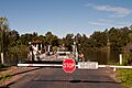
Sackville Ferry departing from the Sackville North side of the Hawkesbury River in 2012
|
|||||||||||||||
| Population | 262 (2011 census) | ||||||||||||||
| Postcode(s) | 2756 | ||||||||||||||
| Elevation | 81 m (266 ft) | ||||||||||||||
| Location | 80 km (50 mi) north-west of Sydney CBD | ||||||||||||||
| LGA(s) | The Hills Shire | ||||||||||||||
| State electorate(s) | Hawkesbury | ||||||||||||||
| Federal Division(s) | Berowra | ||||||||||||||
|
|||||||||||||||
Sackville North is a quiet suburb of Sydney, Australia. It is located in the state of New South Wales, about 80 kilometres north-west of the main city centre. This area is part of The Hills Shire local government area.
Sackville North is right next to another suburb called Sackville. That suburb is in a different area, the City of Hawkesbury. Sackville North is a rural place, meaning it has lots of open land. The Hawkesbury River surrounds it on three sides: north, west, and south. You won't find any shops or petrol stations here. Most of the land is made up of large properties, usually between 2 and 10 hectares (5 to 25 acres). Some properties are even bigger, over 40 hectares.
Contents
History of Sackville North
Naming the Area
The part of the Hawkesbury River near Sackville North is called Sackville Reach. It was named after Viscount Sackville (1716–1785) a long time ago, when Europeans first settled in Australia. The name "Sackville North" was used by people for many years. However, it only became an official name in 1996. This was decided by the Geographical Names Board of New South Wales.
Post Office History
A Post Office called Sackville School opened on March 1, 1911. Later that year, in December, its name changed to Sackville North. It closed in 1957 but then reopened in 1963. It closed again for good in 1975.
Local Shops and Towns
The closest places to find shops are across the river to the west. To get there, you take the Sackville Ferry across the Hawkesbury River. Once you cross, you leave the Sydney area.
Nearby Towns
The first town you reach is Ebenezer, about 5 kilometres away. Further on are some of the "Five Macquarie Towns." These towns were set up by Governor Lachlan Macquarie in 1811. They include Wilberforce (15 km), Windsor (20 km), and Richmond (25 km). The main road to get to Sydney from Sackville North goes through Windsor.
Getting Around Sackville North
River Road and Ferries
River Road runs through the area. To the north, it passes Dargle, a place known for water skiing. This road also crosses the Hawkesbury River again using the Lower Portland Ferry.
Routes to the West
If you head west, you can go to Pitt Town. This is another one of the "Five Macquarie Towns." You can also reach the historic town of Wisemans Ferry. Another option is the Old Northern Road. This road is a different way to get to Sydney. It's important because it doesn't cross the Hawkesbury River. This means it's the only way in or out when the river floods.
Education and Learning
Brewongle Environmental Education Centre
The Brewongle Environmental Education Centre is on Chapel Hill Road. It's a special school run by the NSW government. This centre is built on the site of the old Sackville North Public School. That old school is a historic site, listed as NSW Heritage. It has an old sandstone classroom and a house from 1878.
The centre is located in a sclerophyll forest. This forest is part of the Hawkesbury Valley area. This natural setting is perfect for students to learn. They can study many different ecosystems. They also learn how people have used and changed these environments. This includes learning about the Dreamtime stories of Indigenous Australians up to today.
Historic Places
Churches and Cemeteries
Below the Brewongle Centre, on Mud Island Road, there's an old sandstone church and graveyard from 1869. This was the Sackville North Methodist Church and Cemetery. Nearby, there's also a sandstone house where the vicar used to live. Both the church and the house are now private properties.
Along Mud Island Road, near the Sackville Reach part of the Hawkesbury River, you can find other old houses and remains from early settlements. The Sackville Cemetery is on Sackville Ferry Road. It was officially opened on December 2, 1899. It was also known as "Maroota General Cemetery."
Images for kids
-
Sackville Ferry departing from the Sackville North side of the Hawkesbury River in 2012
