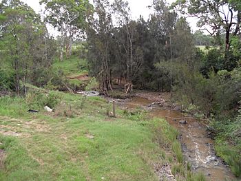
South Creek (New South Wales) facts for kids
Quick facts for kids South |
|
|---|---|

Viewed from Luddenham Road, Orchard Hills, 2013.
|
|
| Country | Australia |
| State | New South Wales |
| Region | Sydney basin (IBRA), Greater Western Sydney |
| Local government areas | Camden, Liverpool, Penrith, Blacktown, Hawkesbury |
| Physical characteristics | |
| Main source | former Oran Park Raceway Oran Park 97 m (318 ft) 34°01′12″S 150°46′34″E / 34.020119°S 150.776058°E |
| River mouth | confluence with the Hawkesbury River near Windsor 2 m (6 ft 7 in) 33°35′56″S 150°50′00″E / 33.598812°S 150.833253°E |
| Length | 70 km (43 mi) |
| Basin features | |
| River system | Hawkesbury-Nepean catchment |
| Tributaries |
|
The South Creek, also known as Wianamatta, is a flowing waterway in Greater Western Sydney, New South Wales, Australia. It's a key part of the larger Hawkesbury-Nepean river system. This creek flows across the Cumberland Plain, an important area in Sydney.
Contents
Journey of South Creek
South Creek starts in Sydney's southwestern suburbs. Its source is near the old Oran Park Raceway. This is about 4 kilometers (2.5 miles) northeast of Narellan. It's also about 7 kilometers (4.3 miles) west of Minto.
In its upper part, the creek forms a border. It separates the suburbs of Oran Park and Catherine Field. The creek then flows mainly north. Many smaller streams, called tributaries, join it. These include Badgerys Creek and Eastern Creek.
Finally, South Creek meets the Hawkesbury River near Windsor. The creek drops 94 meters (308 feet) in height. This happens over its 70-kilometer (43-mile) journey.
Suburbs Along the Creek
As South Creek flows, it passes through or borders many suburbs. These include:
- Bringelly
- Rossmore
- Badgerys Creek
- Kemps Creek
- Claremont Meadows
- Orchard Hills
- Werrington
- St Marys
- Werrington County
- Dunheved
- Llandilo
- Shanes Park
- Berkshire Park
- Windsor Downs
- Riverstone
- Vineyard
- Mulgrave
- Windsor
- McGraths Hill
- Pitt Town Bottoms
Streams Joining South Creek
Many smaller streams flow into South Creek. These are called tributaries.
- At Bringelly, Lowes Creek and Rileys Creek join.
- Thompsons Creek joins at Rossmore.
- Badgerys Creek and Kemps Creek meet it at the suburb of Badgerys Creek.
- Cosgrove Creek joins at Luddenham.
- Blaxland Creek joins at Orchard Hills.
- Byrnes Creek joins at St Marys.
- Claremont Creek joins at Werrington.
- Werrington Creek joins at Werrington County.
- Three unnamed creeks join at Llandilo, Marsden Park, and Riverstone.
- Ropes Creek joins at Shanes Park.
- Eastern Creek joins at Vineyard.
- McGraths Hill Wetlands and McKenzies Creek join at McGraths Hill.
The Name Wianamatta
The name Wianamatta comes from the Dharug language. This is an Aboriginal language. It means 'mother place'. This name shows the deep connection Aboriginal people have to the land.
Evidence of early Aboriginal people has been found. Shell middens (ancient shell heaps) from the Darug people were found near South Creek. These show that Aboriginal people lived and used this area for a very long time.
On March 28, 2003, South Creek was officially given a second name. It became known as Wianamatta as well. This was decided by the Geographical Names Board of New South Wales (GNB).
This dual naming came after a long process. The GNB worked with local Aboriginal Land Councils. They wanted to make sure the Aboriginal name was recognized. They also asked people all over New South Wales for their opinions. This helped make sure everyone knew about the change.
A Look Back in Time
South Creek has a long history in the area. After James Ruse sold his farm in Parramatta, he got land near South Creek. This was in January 1794. For a while, the creek was even called Ruse's Creek.
There used to be a small town called South Creek. It was located near what is now St Marys. This town existed for only a few years. It was part of the early European settlement in New South Wales.
One of the first settlers there was Thomas Jamison (1753–1811). He arrived with the First Fleet. He became the main doctor for New South Wales in 1801. The area of Jamisontown near Penrith is also named after him.
 | Audre Lorde |
 | John Berry Meachum |
 | Ferdinand Lee Barnett |

