North Richmond, New South Wales facts for kids
Quick facts for kids North RichmondNew South Wales |
|||||||||||||||
|---|---|---|---|---|---|---|---|---|---|---|---|---|---|---|---|

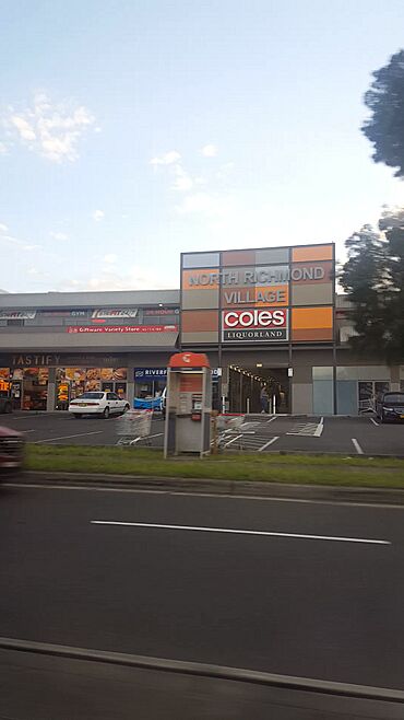
North Richmond's Shopping Village, at the town centre.
|
|||||||||||||||
| Postcode(s) | 2754 | ||||||||||||||
| Elevation | 27 m (89 ft) | ||||||||||||||
| Location |
|
||||||||||||||
| LGA(s) | Hawkesbury | ||||||||||||||
| State electorate(s) | Hawkesbury | ||||||||||||||
| Federal Division(s) | Macquarie | ||||||||||||||
|
|||||||||||||||
North Richmond is a town in New South Wales, Australia. It's about 67 kilometres north-west of the centre of Sydney. The town is part of the City of Hawkesbury area.
The Hawkesbury River separates North Richmond from the town of Richmond to the south-east. Even though it's near Sydney, North Richmond is seen as being on the edge of the Sydney region. Since 2020, the population has grown because of a new housing area called Redbank.
Contents
Exploring North Richmond's Past
The Darug people are the traditional owners of the land where North Richmond is located. They have lived here for thousands of years.
When Europeans first settled here, the area was called Enfield. This name was later changed in the 1800s. It was changed to avoid confusion with another Enfield in western Sydney. People think it was named North Richmond because it was north of Richmond Hill. Governor Philip named Richmond Hill in 1789 while exploring the Hawkesbury River.
Early Buildings and Hotels
In 1833, a hotel called the "Woolpack Inn" opened near the river crossing. It was built by John Town, an important local landowner. In 1874, its name changed to the "Travellers' Rest". A newer hotel was built next to the old inn in 1933. In 1940, it was renamed the "North Richmond Hotel".
Bridges and Railways
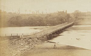
In the 1860s, a wooden bridge was built over the Hawkesbury River. This made it much easier to cross than using the old ferry. In 1905, a new, higher bridge replaced the wooden one. This new bridge was the biggest reinforced concrete bridge built at that time and held that record for 20 years.
In 1926, a railway line opened between Richmond and Kurrajong. A railway bridge was built right next to the concrete road bridge. North Richmond even had its own railway station. When the railway line closed in 1952, the railway bridge became part of the road for cars.
Besides the hotel and school, North Richmond also had a police station, a lockup (a small jail), and a Wesleyan (Methodist) Chapel.
Who Lives in North Richmond?
The 2016 Australian census counted 4,977 people living in North Richmond. Here's a quick look at the population:
- About 4.4% of the people were Aboriginal and Torres Strait Islander people.
- Most people, 83.4%, were born in Australia. The next largest group, 4.5%, were born in England.
- About 90.8% of people spoke only English at home.
- For religion, the most common answers were No Religion (25.7%), Anglican (25.3%), and Catholic (24.7%).
Places to See in North Richmond
North Richmond has three main roads: Grose Vale Road, Bells Line of Road, and Terrace Road.
The town has a shopping mall with a Coles supermarket. You can also find other shops there, like Domino's Pizza and Subway.
There are two main schools: Richmond North Public School (a primary school) and Colo High School. To the west of the town are mountains, and to the east is the Hawkesbury River.
A Panthers Club is also located in North Richmond. For sports, there are three main parks: John Wellington Oval, Turnbull Oval, and Inalls Lane.
- Cricket is played at John Wellington Oval and Turnbull Oval.
- Soccer is played at Turnbull Oval and Inalls Lane. The Colo Cougars Soccer Club plays at Inalls Lane.
Special Heritage Sites
North Richmond has one place listed for its special heritage:
- 108 Grose Vale Road: This is the Yobarnie Keyline Farm. It's important because of its unique farming methods.
Learning in North Richmond: Schools
Richmond North Public School
Richmond North Public School on Grose Vale Road opened in 1871. Before that, a Church of England school had been operating in the area (when it was called Enfield). Mr. George Sanders, who used to lead the old school, became the first teacher at the new public school. The original 1871 school building was taken down in the mid-1960s to build new school buildings.
Colo High School
Colo High School started in 1978 in temporary buildings in North Richmond. The school moved to its permanent location in 1980. The school's colours, blue and white, were chosen by a committee. Mr. Sam Weller, the first Deputy Principal, suggested using the school building plan for the school's logo. Mr. David Stone, a founding Mathematics teacher, drew the design that became the school badge. The shape of the badge also looks like a "Tree of Knowledge." Its three parts represent the Students, Staff, and the Community.
 | Laphonza Butler |
 | Daisy Bates |
 | Elizabeth Piper Ensley |


