
Woolooware facts for kids
Quick facts for kids WooloowareSydney, New South Wales |
|||||||||||||||
|---|---|---|---|---|---|---|---|---|---|---|---|---|---|---|---|

Wills Road, Woolooware
|
|||||||||||||||

Woolooware
Location in Sydney
|
|||||||||||||||
| Population | 3,962 (2016 census) | ||||||||||||||
| Postcode(s) | 2230 | ||||||||||||||
| Elevation | 36 m (118 ft) | ||||||||||||||
| Location | 24 km (15 mi) south of Sydney CBD | ||||||||||||||
| LGA(s) | Sutherland Shire | ||||||||||||||
| State electorate(s) | Cronulla | ||||||||||||||
| Federal Division(s) | Cook | ||||||||||||||
|
|||||||||||||||
Woolooware is a suburb located in southern Sydney, New South Wales, Australia. It is about 24 kilometers (15 miles) south of the main city center of Sydney. Woolooware shares its postcode (2230) with the nearby suburb of Cronulla.
This suburb stretches from Woolooware Bay in the north, which is part of the Georges River estuary. In the south, it reaches Burraneer Bay and Gunnamatta Bay, which are connected to the Hacking River and Port Hacking estuary. Woolooware is surrounded by other suburbs like Cronulla, Caringbah, Burraneer, and Kurnell.
Contents
History of Woolooware
The name Woolooware comes from an Aboriginal word, Wooloowa, which means "muddy track". This name describes the area's natural features, like its low-lying muddy areas and salt marshes. Long ago, the land was covered with tea tree and black wattle plants. The Dharawal and Tharawal peoples were the first owners of this land.
Over time, some of these natural areas, including mangrove swamps, were changed. They became parks and playing fields, such as Endeavour Field and the Woolooware and Cronulla Golf Courses. The area started to be divided into smaller blocks for homes after a railway line opened in 1939. This line connected Sutherland to Cronulla. Woolooware's first public school opened in 1951, and a post office followed in October 1954.
A British construction company, Taylor Woodrow, built some of the first project homes in Australia right here in north Woolooware. You can still see some of these classic red brick homes on Taywood Street.
Who Lives in Woolooware?
According to the 2016 census, there were 3,962 people living in Woolooware. Most residents, about 80.5%, were born in Australia. The next largest group, 4.4%, came from England.
When it comes to languages, 86.8% of people in Woolooware spoke only English at home. For religion, the most common choices were Catholic (29.9%), no religion (26.8%), and Anglican (20.3%).
Shopping and Services
Woolooware has two main small shopping areas.
Woolooware North Shops
One group of shops, known as Woolooware North, is on Wills Road. It's very close to the Woolooware railway station. Here, you can find a general store, a beauty salon, a liquor shop, and a hairdressers. There's also a gift shop, a cafe, a doctor's office, and a Chinese restaurant.
Woolooware South Shops
Another small shopping area, called Woolooware South, is located where Burraneer Bay Road and Woolooware Road meet. These shops include a fish and chip shop, another restaurant, a chemist, a bakery, and a general store. A petrol station is also nearby.
Getting Around Woolooware
Woolooware has good transport options, including a train station and bus services.
Train Services
Woolooware railway station is part of the Sydney Trains network. It's on the Cronulla branch line, which is also known as the T4 line. Like other train stations in New South Wales, you can use an Opal card here.
All trains are double-deck electric trains with eight carriages. They travel to Bondi Junction, stopping at important stations like Sutherland, Wolli Creek, Sydenham, and Central. The station has two platforms and electronic screens to show train times.
Main Roads
Several main roads help people travel through Woolooware. Gannons Road runs north to south. The Kingsway goes east to west, south of the railway line. Captain Cook Drive is to the north and connects Woolooware to Kurnell and Miranda. Burraneer Bay Road leads to Burraneer Bay.
Bus Routes
U-Go Mobility provides several bus services in the Woolooware area:
- 962 travels from Cronulla to Bankstown on weekends only.
- 969 goes from Cronulla to Sutherland.
- 971 connects Cronulla to Hurstville.
- 988 runs from Cronulla to Caringbah (six services per weekday).
During events at the Sharkies club, like NRL games, a special bus runs from the train station to the stadium.
Schools in Woolooware
Woolooware is home to several schools for both primary and secondary students.
Primary Schools
- Woolooware Public School is located on Wills Road.
- Burraneer Bay Public School is on Gannons Road, at the southern edge of the suburb. It has three entry points.
- St Francis De Sales is a Catholic primary school on Hill Street.
High Schools
- Woolooware High School
- De La Salle College
- Our Lady of Mercy College
Sports and Fun in Woolooware
Woolooware is a great place for sports and recreation.
Rugby League
It is the home of the National Rugby League team, the Cronulla-Sutherland Sharks. Their home ground, Remondis Stadium (also known as Endeavour Field), is right next to their club, the Sharkies Leagues Club, on Captain Cook Drive.
Local Sports Grounds
- Woolooware Oval is where the Cronulla Seagulls FC amateur football (soccer) club plays. It's also used for local touch football games. In summer, it's the home ground for the Cronulla Seagulls Cricket Club.
- Captain Cook Fields is the main place for the Sutherland Shire Softball Association. All their competition games are held here.
Images for kids
-
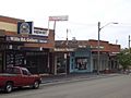
Wills Road shops
-
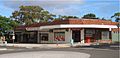
Burraneer Bay Road shops
-
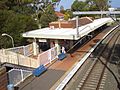
'Old' Woolooware railway station, facing east.
-
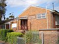
Woolooware Public School
-
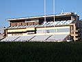
Toyota Park – Endeavour Field
-
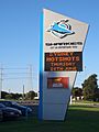
Sharkies Leagues Club sign
-
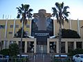
Sharkies Leagues Club building


