
Dolls Point, New South Wales facts for kids
Quick facts for kids Dolls PointSydney, New South Wales |
|||||||||||||||
|---|---|---|---|---|---|---|---|---|---|---|---|---|---|---|---|
| Population | 1,661 (2016 census) | ||||||||||||||
| Postcode(s) | 2219 | ||||||||||||||
| Location | 17 km (11 mi) south of Sydney CBD | ||||||||||||||
| LGA(s) | Bayside Council | ||||||||||||||
| State electorate(s) | Rockdale | ||||||||||||||
| Federal Division(s) | Cook | ||||||||||||||
|
|||||||||||||||
Dolls Point is a small suburb in southern Sydney, Australia. It is located about 17 kilometers south of the Sydney city center. This quiet area is part of the St George region. It is managed by the Bayside Council, which is its local government area.
Contents
Discovering Dolls Point's Past
The history of Dolls Point is quite interesting. Long ago, this area was mostly empty land. People thought it was not a good place to live. The origins of the name "Dolls Point" are a bit unclear. One story says it was named after a person who escaped from prison. This person supposedly hid in the area to avoid being caught by the authorities.
The long stretch of beach between the Cooks River and Georges River was first known as Seven Mile Beach. In 1874, its name was changed to Lady Robinsons Beach. This was done to honor the wife of Governor Sir Hercules Robinson. Cook Park, a popular public area, is named after Samuel Cook. He was a person who strongly believed it should be a place for everyone to enjoy.
A historic building called Primrose House is now the Royal South Sydney Community Health Centre.
Exploring Dolls Point's Geography
Dolls Point gets its name from a special land shape on Botany Bay. Cook Park runs along the eastern edge of the suburb. The beach stretches from Dolls Point all the way to Sandringham Bay. Dolls Point is a calm residential area. It has kept its open spaces and natural beauty. Its friendly, small-town feel makes it a great place for families. It is known for excellent sailing, beautiful water views, and lots of parkland.
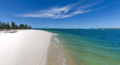
Dolls Point Beach: A Coastal Gem
One of the main attractions here is Dolls Point Beach. It is famous for having some of the whitest sand in Sydney. Fishing and kite surfing are very popular activities on this beach. The beach starts at a rock wall and goes southwest for about 550 meters. It passes a seawall and a small tidal pool. Then it reaches another rock wall in front of a sailing club in Georges River. The beach has a steep slope. This is different from the wide river mouth across the bay to Towra Point.
Local Shops and Services
A small group of shops can be found where Clareville Avenue and Russell Avenue meet. This area is on the border with Sans Souci and Sandringham. The Sans Souci Library is also located here, offering books and resources to the community.
Understanding Dolls Point's Population
According to the 2016 census of Population, there were 1,661 people living in Dolls Point. Most people, about 62.3%, were born in Australia. When it comes to languages spoken at home, 56.3% of people spoke only English. Other languages were also common, with Greek being spoken by 12.6% of residents. For religious beliefs, the most common answers were Catholic (26.1%), Eastern Orthodox (20.0%), No Religion (17.1%), and Anglican (10.3%).
Images for kids
-
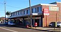
Clareville Avenue, Dolls Point
-
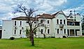
Primrose House
-
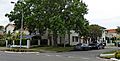
Malua Street
-
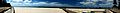
Dolls Point Beach - Peter Despina Reserve/Beach
-
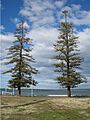
Cook Park
-
Dolls Point Beach

_01.jpg)
.jpg)


