Gymea Bay, New South Wales facts for kids
Quick facts for kids Gymea BaySydney, New South Wales |
|||||||||||||||
|---|---|---|---|---|---|---|---|---|---|---|---|---|---|---|---|

Gymea Bay
|
|||||||||||||||
| Population | 6,892 (2016 census) | ||||||||||||||
| Postcode(s) | 2227 | ||||||||||||||
| Elevation | 66 m (217 ft) | ||||||||||||||
| Location | 27 km (17 mi) south of Sydney CBD | ||||||||||||||
| LGA(s) | Sutherland Shire | ||||||||||||||
| State electorate(s) | Cronulla | ||||||||||||||
| Federal Division(s) | Cook | ||||||||||||||
|
|||||||||||||||
Gymea Bay is a lovely area and suburb in southern Sydney, New South Wales, Australia. It's about 27 kilometres (17 miles) south of the main city area of Sydney. This suburb is part of the Sutherland Shire, which is like its local government area. Gymea Bay shares its postcode, 2227, with the nearby suburb of Gymea.
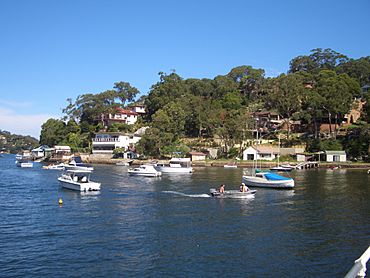
The name "Gymea Bay" comes from the small bay next to it. This bay is on the north side of the Port Hacking river system. The suburb itself is on a small piece of land that sticks out into the water. It's surrounded by Gymea Bay on one side and another part of the Port Hacking River on the other.
In 2008, the NSW Geographical Names Board suggested making the suburb of Gymea Bay much bigger. This new plan would include parts of Gymea and even some of Miranda. However, these areas are separated from the original Gymea Bay by a deep valley with no roads. This idea caused some debate among the local community.
Gymea Bay used to have lots of green bushland. But since the 1980s, more houses have been built on smaller blocks of land. This, along with more cars, has led to fewer large trees. Even though there are rules to protect trees, many have been lost. Also, since the 1990s, feral deer from the Royal National Park have been eating the smaller plants and stopping new trees from growing.
Contents
What Does "Gymea" Mean?
The name "Gymea" comes from the local Eora people. It was their name for the Gymea Lily, a very tall plant that can grow up to 6 metres (20 feet) high. In the Dharawal language, it's called kai'mia.
In 1855, a surveyor named W.A.B. Geaves named the area "Gymea" because these lilies were common there. The Gymea Lily is now a symbol for the area. You can see it on the badges of many local groups. Most of these lilies have disappeared from the suburb due to development. However, you can still find them across the Port Hacking River in the Royal National Park.
A Look Back at Gymea Bay's History
The local Dharawal people used to hunt, fish, and gather food in the Gymea Bay area. They didn't have permanent settlements here, as there were better places nearby. However, you can still find Aboriginal rock markings and shell middens (old piles of shells from meals) near the river.
The settlement of Gymea Bay grew because it was easy to get to the Port Hacking River from here. In 1885, a railway line opened from Sydney to Sutherland. From Sutherland, carts and coaches could easily reach Gymea Bay. Gymea Bay Road originally went all the way to the shore, where a wharf and boat shed were built. Mail and supplies were then taken by boat to houses along the Port Hacking River.
From 1911 to 1931, a tramway ran from Sutherland to Cronulla. Later, in 1939, the Sutherland to Cronulla railway opened with a station at Gymea. These transport links helped Gymea Bay change from a rural area into a popular spot for holidays and recreation. People built fishing shacks and holiday homes. You could also rent boats from the boat shed.
By the 1920s, a coach depot was built where the reserve and playground are now, at the corner of Gymea Bay Road and Casuarina Road. A general store, run by Mr. and Mrs. Jarvis, opened in 1921, and a Post Office followed. Electricity arrived in 1926. Church services started in private homes in 1927, and a church hall, St. Barnabus Church, opened in March 1929.
A community group, now called the Gymea Bay Community Association, was formed. They built a community hall. Running water from pipes started to replace tank water in the 1930s. Gymea Bay Public School opened in August 1935 with 65 students. It was located on the site of the current Old School Park. More shops, churches, a factory, a playground, and tennis courts also appeared near the main intersection.
The Gymea Bay Baths were built, and the Gymea Bay Amateur Swimming Club started using them. There was also a short-lived sailing club. Kemp's Cosy Cabins and Caravan Park offered cabins and camping spots. A petrol station and a larger bus depot also opened.
Changes Over Time
From 1955 onwards, Gymea Bay started to lose some of its unique identity. The public school moved to a new site further up Gymea Bay Road, outside the original Gymea Bay area. The community hall also moved to a new reserve and oval, also outside the original boundaries.
As time went on, many local services closed. Private phone lines became common in the 1960s, so people no longer needed to queue at public phone boxes. By the 1970s, some churches and shops closed. The caravan park closed and was replaced by houses. The Post Office and butcher's shop also closed. The bus depot and service station eventually shut down. The boat shed closed because the Council wouldn't let it open a cafe to help it make money. Public phone boxes disappeared completely with the rise of mobile phones. The old school site was empty for many years before becoming a park with a playground.
In 2008, the Sutherland Shire Council suggested making the suburb of Gymea Bay much larger. This plan included parts of Gymea and Miranda. These areas are separated from the original Gymea Bay by a deep valley. This change made it harder for the original Gymea Bay community to keep its distinct identity.
Who Lives in Gymea Bay?
According to the 2016 census, there were 6,892 people living in Gymea Bay. Most people had English (30.4%) or Australian (29.1%) backgrounds. Other common backgrounds included Irish (10.3%), Scottish (8.0%), and Italian (2.9%).
About 83.7% of residents were born in Australia, and 4.0% were born in England. Most people (90.4%) spoke only English at home. The most common religions were Catholic (28.3%), Anglican (25.4%), and No Religion (25.0%). The average weekly income for households in Gymea Bay was $2,523, which was much higher than the national average of $1,438.
Well-Known People from Gymea Bay
- The Eora people: They are the traditional owners of the land.
- The Hon. Mark Speakman: He is the local member of parliament.
Shops and Services
Gymea Bay is mainly a place where people live. There's a small group of shops on Casuarina Road, near Gymea Bay Road. However, most people in Gymea Bay do their main shopping in the nearby suburbs of Gymea and Miranda.
Schools in Gymea Bay
Gymea Bay Public School is located on Gymea Bay Road. It has become the largest primary school in the Sutherland Shire, based on the number of students.
Fun and Recreation
Gymea Bay is home to the historic Gymea Bay Baths. These baths are located at the shore of Gymea Bay Baths Reserve, where Gymea Bay Road and Ellesmere Road meet. The Gymea Bay Amateur Swimming Club has been using these baths for over 40 years. The bay and the wider Port Hacking river system are very popular for recreation and fishing.
Coonong Creek Bushland Reserve
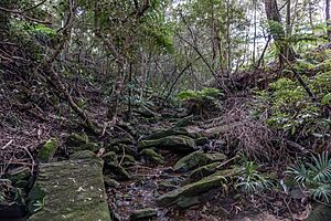
The Coonong Creek Bushland Reserve in Gymea Bay is a natural bushland area. It is looked after by the Sutherland Shire Council and local volunteers. This reserve has walking tracks that connect to the Old School Park and the Gymea Bay Baths Reserve.
How Alkaringa Road Became Part of Gymea Bay
Alkaringa Road used to be part of Miranda. A local real estate agent who lived on this road wanted it to be part of Yowie Bay or Gymea Bay instead. This was partly because being in a more "desirable" suburb can increase property values. One reason given was that children from Alkaringa Road went to Gymea Bay Public School. While a few waterfront homes on Alkaringa Road do face Gymea Bay, many properties in Yowie Bay also face the bay.
The Sutherland Shire Council also saw that changing the suburb boundaries could affect property values and the money they collected from rates. So, they suggested big changes to the established area, making much of Gymea (north of Coonong Creek) and Alkaringa Road in Miranda part of the suburb of Gymea Bay.
 | Chris Smalls |
 | Fred Hampton |
 | Ralph Abernathy |


