Kirrawee, New South Wales facts for kids
Quick facts for kids KirraweeSydney, New South Wales |
|||||||||||||||
|---|---|---|---|---|---|---|---|---|---|---|---|---|---|---|---|
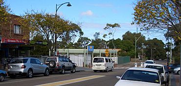
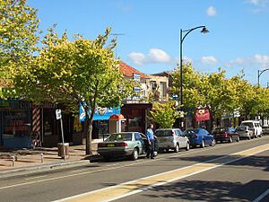
Oak Road, Kirrawee
|
|||||||||||||||
| Population | 9,278 (2016 census) | ||||||||||||||
| • Density | 2,209/km2 (5,720/sq mi) | ||||||||||||||
| Established | 1939 | ||||||||||||||
| Postcode(s) | 2232 | ||||||||||||||
| Elevation | 102 m (335 ft) | ||||||||||||||
| Area | 4.2 km2 (1.6 sq mi) | ||||||||||||||
| Location | 25 km (16 mi) south of Sydney CBD | ||||||||||||||
| LGA(s) | Sutherland Shire | ||||||||||||||
| State electorate(s) |
|
||||||||||||||
| Federal Division(s) | |||||||||||||||
|
|||||||||||||||
Kirrawee is a suburb located in southern Sydney, New South Wales, Australia. It is about 25 kilometres south of the main city centre. Kirrawee is part of the Sutherland Shire area.
This suburb is found between Sutherland to the west and Gymea and Grays Point to the east. The southern edge of Kirrawee touches The Royal National Park, a large natural area. To the north, you'll find the suburbs of Kareela and Jannali.
Kirrawee has both business and living areas. The part north of the train line is mostly for shops and factories. The area south of the train line is mainly for homes. South Kirrawee has many houses with nice views of the bush, stretching down to the Royal National Park. North Kirrawee has smaller factories, car dealerships, and places to eat. Some parts of North Kirrawee also have homes with bush views.
Contents
History of Kirrawee
What Does the Name Kirrawee Mean?
The name Kirrawee might come from an Aboriginal word. One idea is that it means 'lengthy'. Another idea is that it comes from a Dharawal word, "gi(a)rrawee(i)" or "garrawi". This means 'place of white cockatoos' or 'sulphur-crested cockatoos'. The local council now uses 'place of white cockatoos' as the accepted meaning.
Early Days and Development
The name Kirrawee was officially used in 1939. This was when the Sutherland-Cronulla railway line opened. Before this, a postal office called 'Bladesville' operated from a local home.
The Dharawal people lived in this southern Sydney region for at least 8,500 years before Europeans arrived. The area that became Kirrawee was once part of a large estate owned by Thomas Holt. People used to get to the area from Sutherland train station.
In 1911, a tramway opened, making the area easier to reach. Around the same time, a brickworks factory started operating. In 1946, land in Kirrawee became very popular and sold for much more than its original price. By 1949, plans were made to build a primary school in Kirrawee.
Some street names in Kirrawee remember important figures from early Australian history. For example, Bligh Street is named after Governor William Bligh. Johnston Avenue is named after George Bain Johnston, who was involved in Governor Bligh's arrest.
Kirrawee High School opened in February 1966. In the same year, the Housing Commission built affordable homes in Kirrawee. In October 1968, bushfires came close to Kirrawee, but they were controlled.
Today, three houses and the old brick pit site in Kirrawee are listed as heritage sites. This means they are important historical places.
Shopping and Businesses in Kirrawee
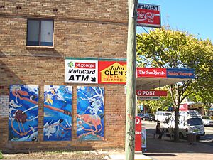
<mapframe text="A map showing the Kirrawee area" width=300 height=300 zoom=13 latitude=-34.0343 longitude=151.0717> { "type": "ExternalData", "service": "geoshape", "ids": "Q6415998" } </mapframe> Kirrawee has a small shopping area on Oak Road, right next to the train station. Here you can find places to eat, a newsagent, and other small businesses. The train station and shops are in the middle of the suburb. There are also some interesting painted murals around the shopping area.
As mentioned, the area north of the train line is mostly for businesses and factories. These include small to medium-sized factories, petrol stations, and car dealerships.
Sylvanvale, an organization that helps people with disabilities, has its main office in Kirrawee. Rudi's Butchery, a German butcher shop, has been in Kirrawee since 1983. In the 1990s, shops selling hardware, furniture, and electronics also attracted many customers. The Shark Island Brewery, which makes beer, opened in the industrial area in 2015.
There is also a small group of shops in Putland Close, behind Kirrawee High School. In 2016, the McDonald's in Kirrawee planned to update its site to have a dual drive-through.
A hotel called The Prince opened in early 2017, across from the old Kirrawee brick pit. It aims to be a family-friendly place.
In 2019, local residents convinced the Council to buy a piece of land near the shopping area. This land was turned into a park to stop a large boarding house from being built there. However, another proposal for a big boarding house near the train station car park was later submitted.
Sydney Turpentine Ironbark Forest
Protecting a Special Forest
Kirrawee is home to important parts of the Sydney Turpentine Ironbark Forest (STIF). This is a critically endangered ecological community, which means it's a very rare type of forest. STIF grows on clay soils, which is different from the sandy soils around it.
These small patches of STIF in Kirrawee show what the original forest looked like before houses were built. Even though most of this forest is gone, small parts still exist. You can see them in protected areas like Flora Street Reserve and Pollard Park. They also grow in older, undeveloped sites like the former Kirrawee Brickpit.
It's thought that only about 0.5% of the original STIF remains in Sydney. These small areas are now protected by laws. The biggest danger to this forest is land clearing for new buildings.
Helping the Forest Grow
Seeds are collected from Kirrawee's protected STIF areas. These seeds are then planted as street trees or in private gardens. This helps to keep the area's natural variety and protect the unique plants that provide homes for native animals.
The local council and community volunteers called Bushcare help look after Kirrawee's STIF reserves. They also run a plant nursery that sells native plants from the local area. Their website helps people choose plants that are good for the local ecosystem.
The Kirrawee Brick Pit Site
The old Kirrawee brick pit is a large 4.5-hectare site. It is just north of the main shopping area. What to do with this site has been a big topic of discussion for local people, politicians, and developers.
History of the Brick Pit
The site was used for making bricks from 1912 to 1979. Different brick companies owned it over the years. The buildings on the site were taken down in 1968. In 1974, Sydney Water Board bought the land. They planned to use it for water storage, but it became a place to store equipment instead.
A Natural Lagoon and Wildlife Home
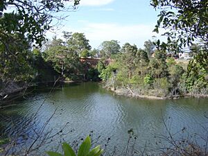
Before recent building started, a deep pit covered about half of the brick pit site. It was like a natural lagoon (a shallow body of water). The rest of the site was covered with trees and plants. It became a home for many different animals, especially birds. The threatened Grey-headed Flying Fox was even seen drinking from the lake.
Plans for New Development
For many years, there was a lot of discussion about what to do with this site. The State Government wanted to sell it to developers to build apartments, businesses, and a small park. However, local groups wanted it to become a performing arts centre and a large park.
In 2001, a long program started to ask the community what they thought. This led to a plan for the Kirrawee shopping village and brick pit. The plan suggested using the site for a mix of businesses, homes, and 20% public park space.
Over the years, different plans were suggested and changed. In 2007, a development group bought the site for $22.5 million. They planned to build apartments, businesses, and a public park.
In 2010, a new development application was submitted for a large project. This included nearly 500 homes and over 13,500 square metres of shops. The local council was against this plan.
In 2012, the re-development of the Kirrawee Brick Pit was finally approved. In 2015, the number of apartments allowed was increased from 432 to 749.
The new shopping centre at the brick pit site is called South Village. Road improvements have been made on nearby streets to help with traffic. The South Village project was expected to create over 1500 jobs. A new library and community hub are also planned for the South Village complex.
Getting Around Kirrawee
Kirrawee railway station is on the Cronulla line. This train line connects Sydney's southern suburbs to the city centre. A train trip to the city takes about 40 minutes. Kirrawee used to have only one train platform. The train line from Sutherland to Cronulla was made into two lines, which finished in 2010.
Some parts of Kirrawee might become part of an extension to the Princes Motorway.
Bus services also run through Kirrawee. U-Go Mobility operates two routes near Kirrawee train station:
- 976: From Sutherland station to Grays Point
- 993: From Westfield Miranda to Engadine
In 2016, about 19.8% of people working in Kirrawee used public transport to get to work. Most people (64.1%) travelled by car.
Schools in Kirrawee
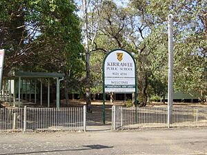
Kirrawee has several schools for students of different ages. These include Kirrawee High School and Kirrawee Public School. There are also many pre-schools and childcare centres. Gymea Technology High School is also very close to Kirrawee.
Churches in Kirrawee
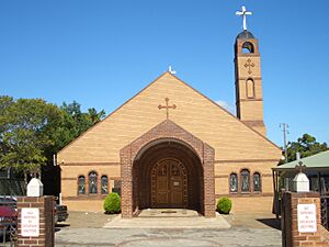
There are several churches in Kirrawee. St. Mary, St. Bakhomious and St. Shenouda Coptic Orthodox Church is located on Bath Road and was opened in 1996. The Soul Revival (Anglican) church meets on Flora Street. The President Avenue Community Church also meets in Kirrawee. There is also a Latter Day Saint Ward on Bath Road.
Parks and Sports in Kirrawee
Kirrawee has several parks and places for sports. Helena Street has a special park where dogs can run off-leash. Nearby, Kirrawee Oval is a sports field with lights, used by the St. Patrick's Sutherland Football Club.
Other parks like Bowie Park, Betham Place Reserve, and Flora Street Reserve have playgrounds for kids.
There is a lawn bowls club on Oak Road called Club Kirrawee. You can also find an indoor climbing centre on Waratah Street in Kirrawee.
Population of Kirrawee
According to the 2016 census, there were 9,278 people living in Kirrawee.
- About 1.2% of the people were Aboriginal and Torres Strait Islander.
- Most people (77.2%) were born in Australia. The next most common countries of birth were England (3.7%), New Zealand (1.8%), and China (1.5%).
- English was spoken at home by 84.6% of people. Other languages included Mandarin (1.3%) and Cantonese (1.3%).
- The most common religions were Catholic (28.0%), No Religion (25.2%), and Anglican (21.7%).
 | Janet Taylor Pickett |
 | Synthia Saint James |
 | Howardena Pindell |
 | Faith Ringgold |


