
Inner West facts for kids
Quick facts for kids Inner West SydneyNew South Wales |
|||||||||||||||
|---|---|---|---|---|---|---|---|---|---|---|---|---|---|---|---|

|
|||||||||||||||
| Population | 304,771 (2021 census) | ||||||||||||||
| LGA(s) |
|
||||||||||||||
| State electorate(s) |
|
||||||||||||||
| Federal Division(s) | |||||||||||||||
|
|||||||||||||||
The Inner West of Sydney is a cool area right next to the Sydney central business district (CBD) in New South Wales, Australia. It's mostly found along the southern side of Port Jackson (which is part of the Parramatta River). The area stretches south all the way to the Cooks River.
The western edge of the Inner West is usually seen as the A3 arterial road. This road helps separate the Inner West from the Greater Western Sydney region. It's important to know that the "Inner West" area is much bigger than just the Inner West Council local government area.
Contents
What are the Inner West Suburbs?

The exact borders of the Inner West are not official. They are more like "customary" boundaries, meaning people generally agree on them. The northern border is the Parramatta River. The southern border is the Cooks River. These natural boundaries are pretty clear.
The western border is a bit trickier to define. It's near where the Cooks River starts and where it gets closest to the Parramatta River. This area has large spaces like rail yards and Rookwood Cemetery. The A3 arterial road (Homebush Bay Drive / Centenary Drive) is now often seen as the western border.
The eastern border is also not super clear. Many suburbs close to the Sydney city centre are sometimes called part of the Inner West. Other times, they are considered part of the "inner city" or Eastern Suburbs.
Some people define the Inner West by the local government areas it includes. This means the Inner West Council, City of Canada Bay, Municipality of Strathfield, and Municipality of Burwood. This definition is often used in local government.
Even real estate agents sometimes include suburbs in the Inner West that are usually not part of it. For example, Wentworth Point is often seen as part of Greater Western Sydney. But sometimes it's called Inner West.
It's a bit of a joke in Sydney that "the inner west is a state of mind." This means its meaning can change depending on who you ask!
Here are the suburbs generally considered part of the Inner West:
|
|
Other suburbs sometimes called Inner West, especially by businesses, include:
History of the Inner West
First Peoples of the Land
Before Europeans arrived, the Sydney area was home to the Darug people. This large group of Aboriginal people was made up of many clans. Each clan lived in a specific area and had about 50 to 100 members. To keep their families healthy, men would marry women from other clans. This meant the clans were all connected. Members often traveled into other clans' lands to hunt, trade, and hold ceremonies. They saw themselves as caretakers of the land, not its owners.
The Inner West was home to two main clans. The Cadigal lived along Port Jackson, from South Head to Lewisham. The Wangal lived just west of the Cadigal, stretching to Homebush Bay. Other clans often visited this area too. These included groups from the Eastern Suburbs, the Cooks River area, and Parramatta.
Early European Settlement

.jpg)
Italianate_mansion_Strathfield-2.jpg)
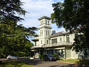
Europeans started getting land in the Inner West in the late 1700s. By 1814, a stage coach ran between Sydney and Parramatta. This helped new towns grow along the coach route, which is now Parramatta Road. Many large land areas were divided up for homes and businesses. For example, Ashfield Park was developed in 1838.
The Main Suburban railway line opened in 1855. This led to even more growth, especially around the new train stations. These stations were in Newtown, Ashfield, Burwood, and Homebush. Rich families, like the Arnotts (who made biscuits) and the Jones family (who owned department stores), built big homes here. They chose areas like Strathfield.
Local governments started forming in the 1800s. This included the Municipality of Newtown in 1862. Other areas like Ashfield, Burwood, and Concord also got their own councils.
Sydney's tram network also grew into the Inner West in the late 1800s. By the early 1900s, trams reached almost every part of the Inner West. A new railway line, the Bankstown Line, opened in 1895. This brought train services to southern Inner West suburbs like Marrickville.
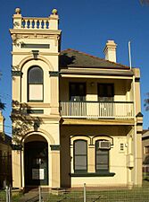
Growth of Industry and Homes
.jpg)

Because of its central spot and easy access by water, rail, and road, the Inner West became a big industrial area. Many large homes were even turned into factories. For example, Abbotsford House became Nestlé's chocolate factory.
But people still loved living in the Inner West. Several Australian prime ministers lived here during this time. New housing styles became popular, like the "garden suburb" of Haberfield. This started in 1901 and is now a protected heritage area.
Between World War I and World War II, the outer suburbs like Strathfield and Burwood became more popular. The inner suburbs like Newtown became less fancy.
After World War II: New People and Changes

After World War II, many new migrants came to Australia. A lot of them settled in the Inner West, especially from European countries. They liked the area because of the factory jobs, its closeness to the city, and good public transport.
These new communities brought their own shops, cafes, and restaurants. This made areas like Haberfield and Leichhardt famous for their Italian businesses. Petersham became a centre for Sydney's Portuguese community.
At first, the inner suburbs were cheaper. But by the end of the 1900s, things changed. Areas like Newtown became popular for alternative cultures. This led to "gentrification," where older areas become more expensive and trendy.
Old factories along the waterfront were turned into apartments. For example, the Colgate-Palmolive factory in Balmain became homes. Many old grand houses were also restored. By 2017, many Inner West suburbs had very high house prices.
Inner West Geography

The Inner West's shape is defined by two rivers. The Parramatta River is its northern border. The Cooks River is its southern border. The western edge is near where the Cooks River begins.
The Parramatta River gets wider here, forming big bays like Homebush Bay and Iron Cove. These bays have greatly affected where roads and railways were built.
Between the two rivers, the land has rolling hills and small valleys. Waterways like Iron Cove Creek flow through these valleys to the rivers. Many of these waterways have been changed over time. Iron Cove Creek, for example, used to have clear swimming holes. Now it's mostly a small stream surrounded by homes and parks.
People of the Inner West

The "Sydney - Inner West" area, as defined by the Australian Bureau of Statistics, covers most of the Inner West. In 2021, this area had over 304,000 people.
- Many people have English, Australian, or Chinese backgrounds.
- Over half of the people have parents born overseas.
- About half of the people were born in Australia.
- The most common birthplaces outside Australia are mainland China, India, and Nepal.
- While most people speak English at home, many also speak Mandarin, Cantonese, or Italian.
- The average weekly household income here is higher than the average for New South Wales and Australia.
Here's a quick look at how the population has changed:
| Historical census data for the Sydney - Inner West | |||||
|---|---|---|---|---|---|
| Census year | 2011 | 2016 | 2021 | ||
| Population | Estimated residents on census night | ||||
| % of New South Wales population | 3.81% | ||||
| % of Australian population | 1.23% | ||||
| Cultural and language diversity | |||||
| Ancestry, top responses |
(% of responses) | (% of responses) | (% of population) | ||
| English | 16.6% | 20.7% | |||
| Australian | 15.7% | 17.8% | |||
| Chinese | 10.3% | 16.5% | |||
| Italian | 8.2% | 9.5% | |||
| Irish | 7.5% | 9.2% | |||
| Language, top responses (other than English) |
Mandarin | 5.9% | |||
| Cantonese | 4.3% | ||||
| Italian | 5.7% | ||||
| Nepali | - | - | 2.9% | ||
| Korean | 2.9% | ||||
| Greek | 2.7% | ||||
| Religious affiliation | |||||
| Religious affiliation, top responses |
No religion, so described | 23.6% | |||
| Catholic | 31.9% | ||||
| Hinduism | 4.5% | ||||
| Anglicanism | 9.6% | ||||
| Not stated | n/c | 9.4% | |||
| Eastern Orthodox | 4.5% | - | |||
| Median weekly incomes | |||||
| Personal income | Median weekly personal income | A$723 | A$828 | A$1,032 | |
| % of Australian median income | 125.3% | 125.1% | 128.2% | ||
| Family income | Median weekly family income | A$1,985 | A$2,284 | A$2,757 | |
| % of Australian median income | 134.0% | 131.6% | 130.0% | ||
| Household income | Median weekly household income | A$1,662 | A$1,964 | A$2,250 | |
| % of Australian median income | 134.7% | 136.6% | 128.9% | ||
Homes in the Inner West
The types of homes in the Inner West show its long history. The oldest parts have stone houses from the Victorian era (1800s) or even earlier. Inner suburbs like Glebe and Newtown have many two-storey terraced houses. They also have one-storey timber cottages.
Further from the city, you can find many grand Victorian-era houses. Many of these have been divided into smaller units or are no longer used as homes. Around the early 1900s, the Federation architecture style became popular for suburban houses. This style later became the Australian Californian bungalow style.
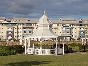
Over the 1900s, more apartment blocks were built, especially near train lines. More recently, taller apartment buildings have appeared. These are often in areas like Strathfield and Burwood. They are also built on land that used to be factories, especially along the Parramatta River. Even with these new buildings, local rules try to keep many areas as low-density housing.
-
Yaralla, in Concord West, built in the 1860s.
-
A Victorian-style house in Marrickville.
-
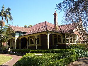
Cassa Tasso, a Federation-era house in Burwood.
-
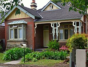
A Federation bungalow house in Ashfield.
-
Breakfast Point, a large housing area built on old factory land.
-
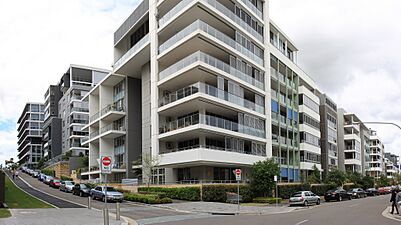
Modern apartment buildings in Rhodes.


Quiroma_in_ABeckett_Avenue.jpg)


Schools and Learning


The Inner West has several universities and colleges. The University of Sydney is at the eastern end in Camperdown. The Australian Catholic University has a big campus in Strathfield. Many students live in the Inner West because it's easy to get to these schools by public transport.
There are also many public and private high schools. Many of these schools have been around since the 1800s. Some government high schools include Fort Street High School (a selective school) and Ashfield Boys High School. There are also private schools like Presbyterian Ladies' College in Croydon.
Getting Around: Transport


The Inner West has great public transport, including trains, buses, ferries, and light rail.
Trains:
- Many Sydney Trains services run through the Inner West.
- The Main Suburban railway line goes from Central Station to Strathfield.
- From Strathfield, lines go to different places like Macarthur and Hornsby.
- The Bankstown Line serves southern suburbs like Marrickville.
- A new rapid transit train line, the Sydney Metro West, is being built. It will connect the Inner West to the Sydney CBD and Parramatta.
Buses:
- Many bus routes are available, mostly run by Transit Systems.
Ferries:
- Sydney Ferries run services on the Parramatta River.
- Sydney RiverCat boats connect Inner West suburbs with northern Sydney, Parramatta, and the Sydney CBD.
Light Rail:
- The Inner West Light Rail connects Central Station to the Inner West.
- It has stops in places like Glebe, Lilyfield, and Dulwich Hill.
Roads:
- Parramatta Road is a main road that goes through the Inner West. It connects Sydney City to Parramatta.
- The M4 is a motorway that runs mostly in a tunnel under the Inner West. It connects to the Anzac Bridge and other motorways.
Cycling:
- More people are using bicycles to get around the Inner West.
- There's a growing network of bike paths and routes.
- Main bike routes include the Cooks River cycleway and the Greenway. These connect different parts of the Inner West and beyond.
Sports in the Inner West
The Inner West is home to some big sports teams.
- In National Rugby League, the area is represented by the Wests Tigers. This team is a mix of the old Balmain and Western Suburbs clubs.
- In rugby union, you can support Sydney Uni or West Harbour.
- For soccer, Leichhardt Oval is the home ground for the A-league team Sydney FC. The area also has other soccer teams like APIA Leichhardt Tigers.
Religion in the Inner West


In the 2021 Census, the most common responses for religion in the Inner West area were:
- No Religion (37.2%)
- Catholic (25.8%)
- Hinduism (6.5%)
- Anglican (5.7%)
The Inner West has many different religious buildings. In the Strathfield-Homebush area, you'll find Catholic institutions like the Australian Catholic University. Strathfield also has the Cathedral of Saints Peter and Paul for the Russian Orthodox Church.
The historic Chinese temple, Sze Yup Temple, is in Glebe. The home of the archbishop for the Maronite Church in Australia is in Strathfield.
