
Strathfield South, New South Wales facts for kids
Quick facts for kids Strathfield SouthSydney, New South Wales |
|||||||||||||||
|---|---|---|---|---|---|---|---|---|---|---|---|---|---|---|---|

Brundah, a Victorian style house on the former Leigh College Campus
|
|||||||||||||||

Strathfield South
Location in Sydney
|
|||||||||||||||
| Population | 3,546 (2016 census) | ||||||||||||||
| Postcode(s) | 2136 | ||||||||||||||
| Elevation | 15 m (49 ft) | ||||||||||||||
| Location | 13 km (8 mi) west of Sydney CBD | ||||||||||||||
| LGA(s) | Strathfield Council | ||||||||||||||
| State electorate(s) | Strathfield | ||||||||||||||
| Federal Division(s) | Watson | ||||||||||||||
|
|||||||||||||||
Strathfield South is a suburb in the Inner West of Sydney, Australia. It is located in the state of New South Wales. This area is about 13 kilometres west of the main city centre of Sydney. It is part of the Strathfield local government area.
Historically, this area was known as Druitt Town. Later, it became part of Enfield. When Enfield Council joined with Strathfield and Burwood councils, the part that went to Strathfield was renamed Strathfield South.
North Strathfield and Strathfield are separate suburbs to the north. Strathfield South is found between Liverpool Road (which is also the Hume Highway) and the Cooks River. Its eastern border is Coronation Parade, and to the west are the Enfield Marshalling Yards.
Contents
History of Strathfield South
Most of Strathfield South sits on two pieces of land given out a long time ago. One was given to James Wilshire in 1808, and it was later called the Redmire Estate. The other was given to Father John Joseph Therry in 1837. This land became known as the Village of St Anne's.
Early Land Development
Wilshire's land was divided into smaller blocks in 1867. It was sold as the 'Redmire Estate'. Some roads in Strathfield South, like Dean Street and Water Street, were created during this time. You can still see a few old Victorian and Federation style houses from this early period.
Father John Joseph Therry received about 19 hectares of land in March 1837. To help pay for the first St. Anne's Church, he offered 1.6-hectare blocks for £25. But there wasn't enough money. So, in 1854, 134 more blocks were sold. The streets in this new area were named after Saints or important church leaders. St Anne's Church is now a protected heritage site in New South Wales.
The area around St Anne's Village and west of Cooks River was locally called Bark Huts. This name came from a hotel on Liverpool Road. It was halfway between Sydney and Liverpool. A small community grew up around this hotel.
From Druitt Town to Strathfield South
The Village of St Anne's and the southern part of the Redmire Estate became known as Druitt Town. Joshua Judge Josephson, who owned a lot of land here, gave it this name. He did it to honour his friend, Major George Druitt.
Druitt Town Public School opened in 1881. In 1885, the part of Druitt Town north of Liverpool Road (which included the school) became part of the new Strathfield Council. After this, addresses in that part of Druitt Town were listed under "Strathfield". This area is now the southern part of the suburb of Strathfield. Druitt Town Public School was renamed Strathfield South Public School.

The rest of Druitt Town became part of Enfield Municipal Council in 1889. Soon after, the name "Druitt Town" was no longer used. Addresses in the suburb were then listed under the suburb of Enfield. The Druitt Town post office also moved to Enfield.
In 1949, this area became part of Strathfield Municipality again. Strathfield Council then renamed the part of the former Enfield Municipality between Liverpool Road and the Cooks River as "Strathfield South". The old Enfield Town Hall and its war memorial are now in Strathfield South. Coronation Reserve is the border between Strathfield South and Enfield. It used to be where a tram line ran, connecting to other areas like Burwood and Ashfield.
In 2021, there was a plan to change the border of Belfield. The northern part of Belfield, which was in the Municipality of Strathfield, would join Strathfield South. This change was approved in 2023.
Heritage Sites
Strathfield South has some important historical places. These are called heritage-listed sites.
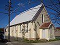
- St Anne's Square: St Anne's Roman Catholic Church, South Strathfield
Population Facts
In the 2016 Census, there were 3,546 people living in Strathfield South.
- About half (50.4%) of the people were born in Australia.
- The next most common countries of birth were China (6.8%), India (5.2%), Sri Lanka (5.2%), and South Korea (3.7%).
- 40.6% of people spoke only English at home.
- Other languages spoken at home included Cantonese (6.8%), Mandarin (6.0%), Arabic (5.9%), Tamil (5.4%), and Korean (4.7%).
- For religion, the most common answers were Catholic (32.2%), No Religion (18.2%), and Hinduism (10.6%).
Local Life in Strathfield South
Strathfield South is mostly a residential area with low-rise homes. There is a small group of shops where Liverpool Road and Homebush Road meet. The first tall building has now been built on the Hume Highway.
The area west and south of the Cooks River is mainly for businesses and factories. This includes the large Enfield Intermodal Logistics Centre. The industrial part is separated from the homes by the Cooks River and parklands.
Churches and Schools
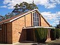
The Catholic church of St Anne's is in St Anne's Square. Strathfield South Uniting Church is on Liverpool Road.
St Anne's Catholic Primary School is located in Strathfield South. Two other schools serve the area but are just outside the suburb: Strathfield South Public School and Strathfield South High School.
- Strathfield South Public School started as Druitt Town Public School in 1881. It is a public primary school (for grades K-6). It serves the area once known as Druitt Town, which is now Strathfield South and the southern part of Strathfield. Its motto is Think of Others.
- Strathfield South High School is a public secondary school (for grades 7–12). It serves Strathfield South, the southern part of Strathfield, and parts of Greenacre and Belfield. Both of these schools are actually on the southern edge of the suburb of Strathfield.
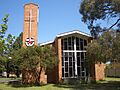
Leigh College was a Methodist Theological College from 1915 to 1974. It was located at 416-420 Liverpool Road. This site is now used by the Australian International Academy, which is an Islamic school.
Parks and Recreation
The area has many parks, such as Ford Park, Dean Reserve, and St Anne's Reserve. St Anne's Reserve runs along the Cooks River. The Bay to Bay Cycle/Walking Path also goes through Strathfield South. This path connects Botany Bay and Homebush Bay (Sydney Olympic Park) and follows the Cooks River.
Gallery
-
St Anne's Catholic Church, a historic place of worship.
-
Strathfield South Uniting Church, a local community church.
-
St Anne's Hall, a building next to the church.
-
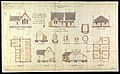
A plan from 1879 for Druitt Town Public School, which is now Strathfield South Public School.


.jpg)
