
Greenacre, New South Wales facts for kids
Quick facts for kids GreenacreSydney, New South Wales |
|||||||||||||||
|---|---|---|---|---|---|---|---|---|---|---|---|---|---|---|---|

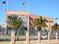
McGuigan Place, Greenacre c. 2007
|
|||||||||||||||
| Population | 24,373 (2016 census) | ||||||||||||||
| Postcode(s) | 2190 | ||||||||||||||
| Elevation | 33 m (108 ft) | ||||||||||||||
| Location | 20 km (12 mi) west of Sydney CBD | ||||||||||||||
| LGA(s) |
|
||||||||||||||
| State electorate(s) | Bankstown | ||||||||||||||
| Federal Division(s) | Watson | ||||||||||||||
|
|||||||||||||||
Greenacre is a suburb in Sydney, New South Wales, Australia. It is about 20 kilometres west of the main city centre. Most of Greenacre is part of the City of Canterbury-Bankstown. A smaller part in the east belongs to the Municipality of Strathfield.
Contents
Discovering Greenacre's Past
This area was once known as East Bankstown. The name 'Greenacre' came about when the first road was built here. An acre of land was cleared for farming, which looked very green compared to the surrounding bush. People started calling it the 'Green Acre'.
In 1909, the Greenacre Park Estate was one of the first areas to be divided into smaller blocks for homes. An inn called the Harp of Ould Erin was also located here, run by Michael Ryan.
Who Lives in Greenacre?
In 2016, about 24,373 people lived in Greenacre. The average age was 33 years old. This means many young families live here, as 24.3% of the people were 14 years old or younger.
More than half of the people (53.3%) were born in Australia. Many others came from Lebanon (13.9%), Vietnam (2.1%), and South Korea (2.0%). The most common family backgrounds are Lebanese, Australian, and English.
While 25.6% of people speak only English at home, many other languages are spoken. Arabic is the most common other language (41.1%). Islam is the most common religion (42.1%), followed by Catholicism (22.4%).
Shopping and Local Businesses
Greenacre has two main shopping areas. In the southern part, you'll find local shops along Waterloo Road and near Juno Parade and Boronia Road. These are often smaller, independent stores.
In the northern part of Greenacre, businesses are often linked to the nearby suburb of Chullora. A larger shopping centre called Chullora Market Place is popular with residents.
Getting Around Greenacre
Greenacre does not have its own train station. However, many bus services connect the suburb to nearby train stations. You can catch a bus to Strathfield, Burwood, Punchbowl, Lakemba, and Bankstown.
Major roads like Waterloo Road, Juno Parade, and Boronia Road run through Greenacre. These roads help people travel easily within the suburb and to other areas.
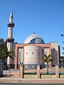
Places of Worship
Greenacre is home to many different churches and mosques.
- Christian churches include: Good Shepherd Anglican Church, St John Vianney & St Thomas More Catholic Church, Greenacre Uniting Church, Greenacre Baptist Church, Greenacre Church of Christ, Sydney Full Gospel Korean Church, and St John's Melkite Catholic Church.
- Mosques and musallahs (prayer rooms) include: Khaled Ibn Al Walid Mosque, Boxing Club Masjid, and Greenacre Musallah.
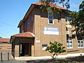
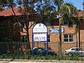
Schools in Greenacre
Greenacre has several schools for students of all ages.
- Public primary schools are: Chullora Public School, Banksia Road Primary School, and Greenacre Public School.
- Private schools include: Greenacre Baptist Christian Community School, St John Vianneys Primary School, Holy Saviour Catholic School, Al Noori Muslim School, Malek Fahd Islamic School, An Nahyan Islamic School, and Sydney Full Gospel Church School.
-
Malek Fahd Islamic School
-
Malek Fahd Islamic School
-
Greenacre Public School
-
Greenacre Public School


Sports and Fun Activities
Greenacre offers many ways to stay active and have fun!
- The Greenacre "Tigers" are the local Rugby League club. They play at Roberts Park.
- You can find a Bowls Club and an RSL Club in Greenacre.
- The Greenacre Area Community Centre offers classes like children's art, yoga, and line dancing.
- Greenacre has three soccer clubs: Chullora Wolves, East Bankstown, and Greenacre Eagles.
- The Greenacre Library and Knowledge Centre is a great place to read and learn. It also has a youth centre.
Parks and Green Spaces
Greenacre has many parks where you can relax and play.
- Northcote Park
- Roberts Park
- Allum Park
- Lockwood Park
- Gosling Park
- Greenacre Heights Reserve
- Bromley Reserve
- Mimosa Reserve
- Norm Nelson Reserve
- Lee Park
- Norfolk Reserve
Greenacre in Pop Culture
Greenacre has even appeared on TV and in movies!
- The SBS TV show Pizza was filmed at a pizza shop on the Hume Highway in Greenacre. A movie called Fat Pizza: The Movie was also made based on the show. The shop was even renamed 'Fat Pizza' for a while!
- The 1966 film They're a Weird Mob shows a house in Greenacre being built. You can see actors digging and pouring concrete for the foundations.
