
Burwood, New South Wales facts for kids
Quick facts for kids BurwoodSydney, New South Wales |
|||||||||||||||
|---|---|---|---|---|---|---|---|---|---|---|---|---|---|---|---|

Burwood Road and part of the heritage-listed Burwood Post Office, designed by Walter Liberty Vernon.
|
|||||||||||||||
| Population | 18,224 (2021 census) | ||||||||||||||
| • Density | 9,100/km2 (24,000/sq mi) | ||||||||||||||
| Established | 1814 | ||||||||||||||
| Postcode(s) | 2134 | ||||||||||||||
| Elevation | 30 m (98 ft) | ||||||||||||||
| Area | 2 km2 (0.8 sq mi) | ||||||||||||||
| Location | 10 km (6 mi) west of Sydney CBD | ||||||||||||||
| LGA(s) | Municipality of Burwood | ||||||||||||||
| State electorate(s) | Strathfield | ||||||||||||||
| Federal Division(s) | Reid | ||||||||||||||
|
|||||||||||||||
Burwood is a lively suburb in the Inner West area of Sydney, New South Wales, Australia. It's located about 10 kilometres (6 miles) west of the main Sydney central business district. Burwood is also the main centre for the Municipality of Burwood, which is its local government area.
Just south of Burwood is Burwood Heights, which is a separate suburb. You might know The Appian Way in Burwood. It's a famous street with beautiful homes built in the Federation style.
Contents
A Glimpse into Burwood's Past

People have lived in the Sydney area for at least 11,000 years. The Indigenous people, especially the Wangal clan, had a deep connection with the land. When the British arrived in 1788, their way of life changed.
In 1799, Captain Thomas Rowley received a large piece of land. He named his property Burwood Farm, after Burwood Park in England. His farm grew to cover about 300 hectares (750 acres). He raised merino sheep there.
The first house in the area, Burwood Villa, was built in 1814. That same year, a stagecoach started running between Sydney and Parramatta. Burwood became a stop along this important road, and a small settlement began to grow.
One important early resident was Dr. John Dulhunty. He was a former naval surgeon and became the Superintendent of Police for the colony in 1826. Dr. Dulhunty was known for fighting a gang of bushrangers who attacked his home, Burwood House. His son, Robert Dulhunty, later founded the city of Dubbo in New South Wales.
As more land was divided and sold in the 1830s, Burwood grew into a village. By 1855, when the railway line opened, Burwood was one of the first six stops on the Sydney-to-Parramatta route. The railway brought a huge increase in people moving to the area. In 1874, Burwood officially became a municipality.
Famous Buildings and Places

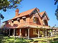
Burwood has many beautiful buildings. They show off different styles like Victorian and Federation.
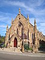
St Paul's Anglican Church on Burwood Road was built in 1871. It was designed by a famous architect named Edmund Blacket. Did you know that Australian cricket legend Sir Donald Bradman got married here in 1932? The church is a very important historical site.
Nearby, in Church Street, is Woodstock. It was built in the early 1870s by a tobacco maker. Over the years, it has been used by the army and as a hostel for new arrivals. Today, it's a community centre, and a local radio station, 2RDJ-FM, broadcasts from there.
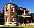
Further down Burwood Road, you'll find The Priory, built in 1877, and Gayton, built in 1888. St Nectarios Greek Orthodox Church in Railway Parade was originally a Methodist church built in 1879.
The Appian Way is a special street running between Burwood Road and Liverpool Road. It was planned by George Hoskins around 1900. Many people say it has some of the best Federation houses in Australia. In the middle of The Appian Way, there's a shared green space that was turned into a lawn tennis club.
Historic Sites to See

Burwood has several places listed for their historical importance. These include:
- Burwood Post Office on Burwood Road.
- St Paul's Anglican Church on Burwood Road.
- The Priory on Burwood Road.
- Burwood railway station, Sydney and the railway bridge.
- The Burwood Sewer Vent, which is a unique old structure.
Other important buildings include:
- Gayton (1888) on Burwood Road.
- Methodist Ladies College on Rowley Street.
- Woodstock on Church Street.
- St Nectarios Greek Orthodox Church on Railway Parade.
Burwood Park: A Green Space

Burwood Park was created by the local council in 1882. It was originally designed to look like the Union Jack flag! Later, a cricket oval was added.
The park has many features, including:
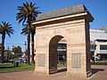
- Memorials for soldiers who died in World War I and Sandakan.
- A rotunda (a round building with a dome).
- A playground for kids.
- A small lake.
- An obelisk (a tall, thin monument) marking where Burwood Villa, the area's first house, once stood.
Burwood Park is also where "Carols in the Park" is held every Christmas. It's located on Burwood Road, right across from Westfield Burwood.
| Burwood Park | |
|---|---|

Lake in Burwood Park
|
|
| Lua error in Module:Location_map at line 420: attempt to index field 'wikibase' (a nil value). | |
| Type | Urban park |
| Location | Burwood, Burwood Council, Sydney, New South Wales, Australia |
| Created | 1882 |
| Operated by | Burwood Council |
| Open | 24 hours |
| Status | Open all year |
Burwood's Shopping and Business Hub
Burwood has a mix of homes, shops, and light industry. The main shopping area is along Burwood Road, right next to the railway station.
Westfield Burwood is a big shopping centre north of the railway line. It's across the road from Burwood Park. Burwood Plaza is a smaller shopping centre south of the railway line.

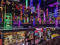
You'll also find "Burwood Chinatown" (traditional Chinese: 寶活中國城; simplified Chinese: 宝活中国城). It's an arcade that connects Burwood Plaza to Burwood Road.
Tall residential and office buildings are also common in the streets around the railway line. More businesses and light industries are located along Parramatta Road.


_OCT2019.jpg)
Getting Around Burwood
Burwood is very well connected by public transport. Burwood railway station is a major hub. It's on the T9 Northern and T2 Inner West & Leppington lines of the Sydney Trains network.
Many Transit Systems buses serve Burwood. You can catch buses to places like Hurstville, Rockdale, Mascot, Strathfield, and Ryde. There are two main bus stops: Burwood station and Westfield Burwood.
A new rapid transit station, Burwood North, is planned for the future as part of the Sydney Metro West project.
Who Lives in Burwood?
In 2016, Burwood had over 16,000 residents. Many people in Burwood have Chinese heritage (45.1%). Other common backgrounds include English, Australian, Indian, and Korean. About 25% of residents were born in Australia.
Besides English, many other languages are spoken at home. Mandarin is the most common (34%), followed by Cantonese, Korean, Nepali, and Italian.
Sister Cities
Burwood has special connections with five "sister cities" around the world:
 Tianjin, China
 Calabria, Italy
 Imar, Lebanon
 Sandakan, Malaysia
 Utica, New York, United States of America
 Geumcheon, South Korea
Images for kids
-
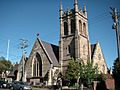
St Paul's Anglican Church, Burwood Road
-
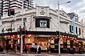
The Burwood Hotel, Burwood Road
-
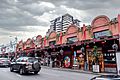
Burwood Chinatown, Burwood Road
-
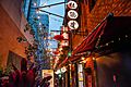
Burwood Chinatown Laneway, Clarendon Place
-
Southern Cross Catholic Vocational College, Comer Street
-
Deolee (c. 1891), Burwood Road
-
St Nectarios Greek Orthodox Church, Railway Parade
-
War Memorial in Burwood Park
-
Burwood Chinatown


Southern_Cross_Catholic_Vocational_College_Burwood.jpg)


See also
 In Spanish: Burwood (Nueva Gales del Sur) para niños
