
Meadowbank, New South Wales facts for kids
Quick facts for kids MeadowbankSydney, New South Wales |
|||||||||||||||
|---|---|---|---|---|---|---|---|---|---|---|---|---|---|---|---|

Meadowbank railway shops and outdoor eating area
|
|||||||||||||||
| Population | 5,089 (2021 census) | ||||||||||||||
| • Density | 7,300/km2 (19,000/sq mi) | ||||||||||||||
| Established | 1801 | ||||||||||||||
| Postcode(s) | 2114 | ||||||||||||||
| Elevation | 20 m (66 ft) | ||||||||||||||
| Area | 0.7 km2 (0.3 sq mi) | ||||||||||||||
| Location | 15 km (9 mi) north-west of Sydney CBD | ||||||||||||||
| LGA(s) | City of Ryde | ||||||||||||||
| State electorate(s) | Ryde | ||||||||||||||
| Federal Division(s) | Bennelong | ||||||||||||||
|
|||||||||||||||
Meadowbank is a suburb of Sydney, New South Wales, Australia. It is located about 15 kilometres north-west of the Sydney city centre. Meadowbank is part of the City of Ryde local council area. It sits in a valley on the northern side of the Parramatta River.
Contents
History of Meadowbank
First Nations People
The land from Sydney Cove to Parramatta, on the north side of the Parramatta River, was home to the Wallumattagal people. Their land was known as Wallumetta.
Aboriginal people in the Sydney area lived in groups called clans. These clans were part of larger groups that shared a language. The Wallumattagal people likely spoke the Dharug language.
European Settlement and Growth

In 1794, a large piece of land was given to Surgeon William Balmain. He named it 'Meadow Bank'. When Balmain went back to England in 1801, another surgeon, D'Arcy Wentworth, managed his land.
Wentworth later sold the 'Meadow Bank Estate' to John Bennett, who had come to Australia as a convict. By 1819, Bennett owned both 'Meadow Bank Estate' and 'Chatham Farm'. His nephew, William Bennett, joined him in 1823.
After John Bennett died in 1829, William inherited the land. He built Meadowbank House around 1835. The land was later divided into smaller blocks in the late 1880s. This happened after the Main Northern railway line opened in 1886.
Meadowbank station first opened as Hellenic. It was later renamed Meadowbank, after the old estate.
Early Industries and Transport

The Meadowbank Manufacturing Company Works was the first big industry in Meadowbank. It started in 1890 on 95 acres of land. It was located by the Parramatta River and close to the railway. The company made farm equipment for local use and for other parts of Australia.
Shepherds Bay is named after James Shepherd, an early settler. Row boat ferries started operating from Schooner Wharf as early as 1794. They took people across the river to the Concord side.
The Ryde to Rhodes punt (a type of ferry) ran between 1898 and 1935. It carried people and even cattle. Sometimes, the cable holding the punt would break, and the cattle would float down the river!
The Ryde Bridge was built in two years and opened in 1935. People had to pay a toll to cross it until 1949. The John Whitton Bridge, a railway bridge, opened in 1980. The older railway bridge is now used for cycling.
Heritage Sites
Meadowbank has some important historical sites. These are places that are protected because of their history. One of these is the:
Shopping and Business Areas
Meadowbank has a mix of shops and homes. There are shops on both sides of Meadowbank railway station. There is also a shopping centre inside a group of apartment buildings along Bay Drive.
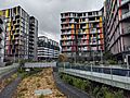
Many modern apartment buildings are built along the waterfront. They offer great views of the Parramatta River. You can also find cafes and restaurants along the water's edge.
Meadowbank TAFE is a large college located on the east side of the station. It is one of the biggest TAFE NSW colleges in Sydney.
Getting Around Meadowbank
Roads and Traffic
Meadowbank is easy to get to by car, ferry, bus, and train. It doesn't have much traffic because the main roads go around the suburb, not through it. Key roads include Lane Cove Road to the east and Victoria Road to the north.
Train Services

Meadowbank railway station is on the Main Northern railway line. Trains run regularly, with more services during busy times on weekdays. The station is also close enough to walk to the ferry wharf.
Ferry Services
Meadowbank has a ferry wharf on the Parramatta River. It is part of the Sydney Ferries network. You can catch a ferry to places like Sydney Olympic Park or Kissing Point. Ferries are popular with tourists on weekends and people who work in the city during the week.
Places to See and Visit
Schools in Meadowbank
- Meadowbank Multipurpose Learning Centre: A childcare centre for young children. It also offers before and after school care for Meadowbank Public School students.
- The Italian Bilingual School: This school moved to Meadowbank in 2013. It teaches students in both English and Italian.
- Meadowbank TAFE: A large college offering many different courses.
- St Michael's School: A Catholic primary school started in 1922.
- Meadowbank Public School.
- Marsden High School: A high school for students in years 7-12. It is located in the new Meadowbank Education Precinct. It also has a special centre for high school students who are new to Australia and need to learn English.
Churches
- Meadowbank International Church
- Ryde Presbyterian Church
- St. Michael's Catholic Church
- River City Church
Parks and Green Spaces
Meadowbank offers great access to the Parramatta River and its parks.
- Meadowbank Park: A large sports area for football, soccer, cricket, baseball, hockey, and netball. It has a bike and jogging track along the Parramatta River. This track is part of the Parramatta Valley Cycleway.
- Memorial Park: Located next to the Parramatta River. It also has a bike track that is part of the Parramatta Valley Cycleway. The RiverCat Ferry Wharf is here. There is a special World War II Memorial Walk built with stones from countries where Australians served.
- Anderson Park
- Ann Thorn Park
- Helene Park
- Headland Park
- Woolway Park
Waterways
- Archers Creek
- Charity Creek
- Parramatta River
- Smalls Creek
Scout Halls
- 1st Meadowbank Scout Group: Located on Angas Street.
- Epping Scout Group: Has a boat shed on Bowden Street, near the ferry wharf. They use it for sailing and canoeing in summer.
People of Meadowbank
In 2021, the population of Meadowbank was 5,089 people. About 49.2% were male and 50.8% were female.
Many people in Meadowbank come from different parts of the world. About 37.4% of people were born in Australia. Other common birthplaces include China (11.7%), South Korea (7.8%), and India (6.1%).
While 38.2% of people spoke only English at home, many other languages are also spoken. These include Mandarin (13.2%), Korean (9.4%), and Cantonese (6.4%).
Most homes in Meadowbank are flats or apartments (96.8%).
Images for kids
-
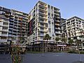
Apartments along the Meadowbank waterfront
-
Rothesay Avenue


