
Huntleys Point, New South Wales facts for kids
Quick facts for kids Huntleys PointSydney, New South Wales |
|||||||||||||||
|---|---|---|---|---|---|---|---|---|---|---|---|---|---|---|---|

Huntleys Point from the Parramatta River
|
|||||||||||||||
| Population | 144 (2016 census) | ||||||||||||||
| Postcode(s) | 2111 | ||||||||||||||
| Location | 9 km (6 mi) north-west of Sydney CBD | ||||||||||||||
| LGA(s) | Municipality of Hunter's Hill | ||||||||||||||
| State electorate(s) | Lane Cove | ||||||||||||||
| Federal Division(s) | North Sydney | ||||||||||||||
|
|||||||||||||||
Huntleys Point is a small area, called a suburb, located in the northern part of Sydney, New South Wales, Australia. It's about nine kilometres north-west of the main city centre, known as the Sydney CBD. This suburb is part of the Municipality of Hunter's Hill, which is a local government area that manages services for the community.
Huntleys Point sits right on the northern shore of the Parramatta River. It was named after Alfred Reynolds Huntley. He bought the land where the suburb is now and built a house called Point House in 1851. Alfred Huntley and his family first arrived in Australia in 1836.
This area is also important because it's where the north-western end of the famous Gladesville Bridge is located. People can also travel to and from Huntleys Point by ferry, as it has its own ferry stop called the Huntleys Point ferry wharf.
Images for kids
-
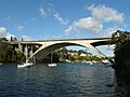
Tarban Creek Bridge
-
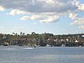
Huntleys Point, viewed from Chiswick


