
Duck River (New South Wales) facts for kids
Quick facts for kids Duck |
|
|---|---|

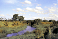
Duck River, looking towards the Mona Street bridge, South Granville in 1976.
|
|

NASA satellite view of Greater Metropolitan Sydney, with the location of the mouth of the Duck River, as marked
|
|
| Country | Australia |
| State | New South Wales |
| Region | Sydney basin (IBRA), Greater Western Sydney |
| LGAs | City of Canterbury-Bankstown, City of Parramatta, Cumberland Council |
| Physical characteristics | |
| Main source | Sydney Water Supply Pipeline Birrong/Sefton 33°52′42″S 151°0′47″E / 33.87833°S 151.01306°E |
| 2nd source | A'Becketts Creek Rosehill 33°49′46.98″S 151°1′21.93″E / 33.8297167°S 151.0227583°E |
| River mouth | Parramatta River Silverwater 33°49′28.87″S 151°2′56.35″E / 33.8246861°S 151.0489861°E |
| Length | 11.5 km (7.1 mi) |
| Basin features | |
| River system | Parramatta River catchment |
| Tributaries |
|
The Duck River is a river in Sydney, New South Wales, Australia. It is a smaller river that flows into the Parramatta River. It's called a perennial stream because it flows all year round.
Contents
History of Duck River
First People of the Land
The Darug people were the first people to live on the land around the Parramatta River. The Burramattagal clan, a group within the Darug, lived near the head of the river. The southern riverbank was very important for finding food and other resources. They moved their camps around their land during different seasons. They found lots of fish, shellfish, birds, and animals like kangaroos and possums to eat. The Duck River was likely the border between the Burramattagal country and their neighbours, the Wategora clan.
European Arrival
On April 22, 1788, Governor Arthur Phillip and his group traveled inland by boat from Sydney Cove. They were looking for better farmland for the new settlement. They landed near Clyde at the end of the river they could travel by boat. Governor Phillip named it Duck River because he saw so many ducks there. They tried to explore the land, but the thick bush was too hard to get through.
Early Developments
In the early 1800s, John Macarthur, a famous wool pioneer, expanded his land. He owned all the land along the river between Parramatta and Duck River.
Old maps show that the Duck River area, especially downstream from where A'Becketts Creek joins it, used to be a wetland. This wetland had saltmarshes, rushes, and grasses. Further upstream, the Eucalypt forest next to the river was cut down. This happened in the 1850s to provide wood for railway sleepers and firewood. This was needed during and after the building of the Sydney to Parramatta railway.
Later, industries were built near the river. In 1898, the Clyde Engineering company was built. In 1908, the Fells Oil Refinery opened, and in 1928, the Clyde Refinery was built on the left bank where Duck River meets the Parramatta River.
Geography of Duck River

The Duck River flows for about 11.5 kilometres (7.1 mi) (about 7 miles). It starts from a drain in Birrong and flows generally north, then east-north-east. It joins the Parramatta River at Silverwater. Closer to the Parramatta River, it becomes a tidal creek. This means the water level goes up and down with the ocean tides.
Important Wetlands
The wetlands along the Duck River are very important for nature. They are home to three types of Endangered Ecological Communities. These are groups of plants and animals that are at risk of disappearing. Many threatened species also live there. The local community really values these wetlands.

River's Path
The Duck River Catchment is the area of land where all the rain and water drain into the river. It starts in the Bankstown area, near Bankstown and Condell Park. The water flows north through pipes and open drains to the Sydney Water Supply Pipeline at Sefton. This pipeline marks the border between Bankstown City and Parramatta City. From there, the river becomes more natural. It flows through the Parramatta and Auburn areas before joining the Parramatta River.
Further downstream, A'Becketts Creek flows into the Duck River at Rosehill. This is near where the M4 Western Motorway crosses James Ruse Drive.
Wategora Reserve
Wategora Reserve is a special natural area named after the Wategora tribe. They were also known as the Duck River Tribe and lived along the Duck River. This important bushland area is about 5 kilometres (3.1 mi) south of the Parramatta River, across from Auburn Golf Course.
Plants and Animals
The reserve is home to 246 different types of native plants. It is a remaining part of the Cumberland Plain Woodland, a type of forest. The main trees are grey box and broad-leaved ironbark. Three kinds of tea trees (Melaleuca) are also common. You can also find unusual plants like turpentine, cheese tree, red mahogany, and coffee bush in wetter spots. Grey gum trees grow near a rock outcrop called Minchinbury Sandstone.
In late winter, many wildflowers bloom, and you might even spot small orchids. Because the reserve is surrounded by suburbs, it has problems with weeds. However, there are programs to help restore the native bushland.
The reserve is also home to many native animals. You can find possums, many types of birds, and reptiles. These reptiles include the water skink and the red-bellied black snake. Birds like Budgerigars and brush turkeys have also been seen in the reserve.
Images for kids
-
Duck River, looking towards the Mona Street bridge, South Granville in 1976.
