South Granville, New South Wales facts for kids
Quick facts for kids South GranvilleSydney, New South Wales |
|||||||||||||||
|---|---|---|---|---|---|---|---|---|---|---|---|---|---|---|---|

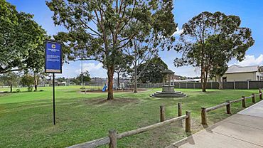
Colquhoun Park
|
|||||||||||||||
| Population | 5,500 (2016 census) | ||||||||||||||
| Postcode(s) | 2142 | ||||||||||||||
| Elevation | 20 m (66 ft) | ||||||||||||||
| Location | 23 km (14 mi) west of Sydney CBD | ||||||||||||||
| LGA(s) | Cumberland City Council | ||||||||||||||
| State electorate(s) |
|
||||||||||||||
| Federal Division(s) | |||||||||||||||
|
|||||||||||||||
South Granville is a friendly suburb located in western Sydney, New South Wales, Australia. It's about 23 kilometers west of the main city center of Sydney. This area is part of the Cumberland City Council, which helps manage local services.
South Granville is like a neighbor to Granville. They even share the same postcode, 2142. Other nearby places like Camellia, Holroyd, and Rosehill also use this postcode.
A Glimpse into South Granville's Past
The name "Granville" was chosen in 1880. It was named after a British leader called Granville Leveson-Gower, 2nd Earl Granville. He was an important person in the British government at the time.
Fun Places and Green Spaces
South Granville has many great parks and sports grounds where you can play and relax. These green spaces are perfect for outdoor activities.
- Ray Marshall Reserve
- Horlyck Reserve and playground
- Harry Gapes Reserve
- Colquhoun Park
- Everley Park
- Melita Stadium
Learning and Schools
There are several schools in and around South Granville. These schools help students learn and grow.
- Granville East Public School
- Blaxcell Street Public School
- Holy Family Primary School
- Granville South Creative and Performing Arts High School
- Granville South Public School
 | Shirley Ann Jackson |
 | Garett Morgan |
 | J. Ernest Wilkins Jr. |
 | Elijah McCoy |


