
Holroyd, New South Wales facts for kids
Quick facts for kids HolroydSydney, New South Wales |
|||||||||||||||
|---|---|---|---|---|---|---|---|---|---|---|---|---|---|---|---|

Former brickworks
|
|||||||||||||||
| Population | 1,275 (2016 census) | ||||||||||||||
| Postcode(s) | 2142 | ||||||||||||||
| Elevation | 18 m (59 ft) | ||||||||||||||
| Location | 20 km (12 mi) W of Sydney CBD | ||||||||||||||
| LGA(s) | Cumberland Council | ||||||||||||||
| State electorate(s) | Granville | ||||||||||||||
| Federal Division(s) | Parramatta | ||||||||||||||
|
|||||||||||||||
Holroyd is a small suburb located in western Sydney, New South Wales, Australia. It is about 20 kilometers west of the main city center of Sydney. Holroyd is part of the Cumberland Council area.
The name "Holroyd" comes from Arthur Holroyd, who was the first mayor of the area. He was also an important local landowner and businessman. The main administrative office for the area is in nearby Merrylands. Holroyd shares its postcode, 2142, with other nearby suburbs like Granville, South Granville, Camellia, and Rosehill.
Contents
History of Holroyd
Arthur Holroyd's Contributions
Arthur Todd Holroyd (1806-1887) was a very important person in the history of Holroyd. He bought land in the area in 1855. This land was named Sherwood Scrubs, after his old home in England.
Arthur Holroyd was a Member of Parliament and a judge for the New South Wales Supreme Court. He was also a keen businessman and was involved in many different groups and committees. He became the first mayor of Holroyd Council in 1872. He helped bring important changes to the area, like making clay pipes for drainage. He also encouraged the building of the railway line to Parramatta Junction.
How the Suburb Was Created
The suburb of Holroyd was officially created in 1999. Before this, the local government area called Holroyd Council did not have a suburb with the same name. The New South Wales Geographical Names Board decided that every council area should have a suburb named after it.
So, the suburb of Holroyd was officially named in 1999. Its original boundaries were Walpole Street to the north, Neil Street to the south, the railway line to the east, and Pitt Street to the west. In 2001, the northern boundary was extended to the freeway.
Landmarks in Holroyd
One important landmark in Holroyd is the area where the historic Goodlet and Smith Brickpit used to be. This was a large clay pit. Today, this site has been turned into a beautiful place called Holroyd Gardens Park.
There is also the Holroyd Gardens Estate. This is a modern housing development that includes some of the old brickwork kilns and buildings. These buildings show the history of brick-making in the area.
Population and Culture
Who Lives in Holroyd?
According to the 2016 census, there were 1,275 people living in Holroyd. The suburb is a mix of different cultures. About 35.7% of the people were born in Australia. The next largest group, at 9.0%, was people born in India.
Languages and Religions
In Holroyd, 27.3% of people spoke only English at home. Other languages spoken included Arabic, which was spoken by 8.3% of residents. The most common religions in Holroyd were Islam (27.2%), Catholic (18.4%), and Hinduism (10.2%). About 18.0% of people said they had no religion.
Images for kids
-
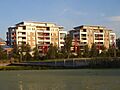
Modern apartments built where brickworks once stood.

