Haslams Creek facts for kids
Quick facts for kids Haslams Creek |
|
|---|---|

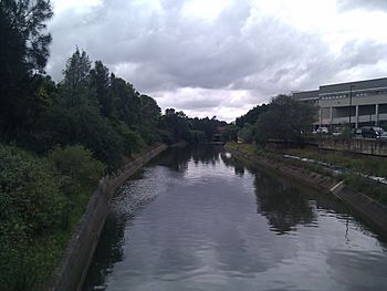
View of the creek from the bridge
|
|
| Country | Australia |
| Municipality | Sydney |
| Physical characteristics | |
| Main source | Rookwood Cemetery Rookwood 33°52′27.006″S 151°3′33.2994″E / 33.87416833°S 151.059249833°E |
| River mouth | Parramatta River Homebush Bay 33°50′4.0194″S 151°4′34.68″E / 33.834449833°S 151.0763000°E |
| Basin features | |
| River system | Parramatta River |
Haslams Creek is a small river, also called a tributary, located in Sydney, Australia. It flows west of Sydney Harbour and eventually joins the larger Parramatta River at Homebush Bay. You can find parts of Haslams Creek flowing through Sydney Olympic Park.
Contents
About Haslams Creek
Haslams Creek starts in the suburb of Rookwood. The total area of land that drains into Haslams Creek, known as its catchment area, is about 17 square kilometers (6.6 square miles).
Upper and Lower Creek Areas
The creek is divided into two main parts:
- The Lower Haslams Creek area is found between Homebush Bay and the M4 Freeway.
- The Upper Haslams Creek area stretches from the M4 Freeway to Rookwood Cemetery. This part of the creek flows through many city areas.
In the upper part of the creek, the water often flows through man-made channels and pipes. Further downstream, from the M4 Freeway to the Hill Road Bridge, the creek also flows through a formal channel. After the Hill Road Bridge, the creek returns to its natural path until it reaches Homebush Bay. Sydney Water looks after the formal channels, while the natural parts are managed by NSW Roads and Maritime Services.
Tides and Mangroves
The tide from the ocean affects Haslams Creek up to about 350 meters (1,150 feet) upstream of the Great Western Highway. You can also find mangrove trees growing along the creek. These special trees stop growing about 100 meters (330 feet) downstream from the freeway.
Restoring Haslams Creek Wetland
The Haslams Creek Wetland is a special area located between Bennelong Parkway and Homebush Bay. This wetland was chosen as a test site for a big project to clean up and restore the land for the Sydney 2000 Olympic Games.
The New South Wales Olympic Coordination Authority worked to restore two salty wetlands in Homebush Bay. One of these was at Haslams Creek. To help the wetland recover, they changed how water flowed through the area and how sediment (like mud and sand) settled. They then planted pieces of six different plant types from nearby healthy areas.
For two years, scientists watched how well these plants grew and survived. They wanted to learn how things like saltiness, sediment, and the tide affected the plants. This information helps them understand how saltmarsh areas grow and form in restored wetlands.
Important Structures
Haslams Creek Bridge
The Haslams Creek Bridge is an old bridge located in Lidcombe. It was built around 1928 and is made of reinforced concrete. This bridge crosses Parramatta Road, which is also known as the Great Western Highway.
The bridge and a nearby culvert (a tunnel for water to flow under a road) are still used today. This bridge is important because it allowed Parramatta Road to be built in a straight line. This helped new industries and businesses grow in nearby suburbs like Auburn, Clyde, Granville, and Parramatta. The Haslams Creek Bridge is listed on the New South Wales Heritage and conservation register because of its historical importance.
 | Shirley Ann Jackson |
 | Garett Morgan |
 | J. Ernest Wilkins Jr. |
 | Elijah McCoy |

