
Queanbeyan River facts for kids
Quick facts for kids Queanbeyan River |
|
| Burra Creek, Sallee Creek | |
| Perennial stream | |
 Road bridge carrying the Kings Highway over the Queanbeyan River, in Queanbeyan
|
|
| Name origin: Aboriginal (Ngarigu): "clearwater" | |
| Country | Australia |
|---|---|
| Regions | South Eastern Highlands (IBRA), Monaro, Capital Country |
| Local government areas | Cooma-Monaro, Queanbeyan |
| Part of | Murrumbidgee River, Murray-Darling basin |
| City | Queanbeyan |
| Source | Gourock Range |
| - location | east of Bredbo, New South Wales |
| - elevation | 1,260 m (4,134 ft) |
| - coordinates | 35°56′24″S 149°27′35″E / 35.94000°S 149.45972°E |
| Mouth | confluence with the Molonglo River |
| - location | Oaks Estate, Australian Capital Territory |
| - elevation | 567 m (1,860 ft) |
| - coordinates | 35°20′13″S 149°13′51″E / 35.33694°S 149.23083°E |
| Length | 104 km (65 mi) |
| Basin | 96,000 km² (37,066 sq mi) |
| Reservoirs | Googong Reservoir, Queanbeyan Weir |
The Queanbeyan River is a river in New South Wales, Australia. It is a perennial stream, which means it flows all year round. This river is an important part of the Molonglo River system. It also belongs to the larger Murray-Darling Basin, a huge area of land where all the water drains into the Murray River and Darling River.
The Queanbeyan River is about 104 kilometers (65 miles) long. Its catchment area is very large, covering about 96,000 hectares (237,225 acres). The river helps supply drinking water to the cities of Canberra and Queanbeyan. The water quality in this area is carefully protected by Australian laws.
The name Queanbeyan comes from the Aboriginal Ngarigo people. They used a word that sounded like queanbeyan to describe the river. This word meant "clearwater," which tells us how clean and clear the river once was.
Contents
Where the River Flows
The Queanbeyan River starts in the Gourock Range in New South Wales. This is a mountain range east of a town called Bredbo. The river begins its journey high up, at an elevation of 1,260 meters (4,134 feet) above sea level.
Journey to the Molonglo
As the river flows, it passes through different areas. It goes through parts of New South Wales, including the Monaro and Capital Country regions. Eventually, it reaches the Australian Capital Territory.
Meeting Other Rivers
The Queanbeyan River ends when it joins with the Molonglo River. This meeting point is called a confluence. It happens near a place called Oaks Estate in the Australian Capital Territory. At this point, the river is much lower, at an elevation of 567 meters (1,860 feet).
Water Supply and Protection
The Queanbeyan River is very important for providing water to people. Along with the Cotter River, it helps meet the drinking water needs for thousands of people in the Canberra and Queanbeyan areas.
Protecting Our Water
Because the river is a source of drinking water, its quality is very important. The Australian government has special laws to protect the water in the Queanbeyan River. This helps make sure the water stays clean and safe for everyone to use.
Googong Dam
One important part of the river system is the Googong Dam. This dam creates a large reservoir called Googong Reservoir. Reservoirs are like big lakes that store water. The Queanbeyan Weir is another structure on the river that helps manage water flow.
Images for kids
-
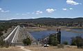
Googong Dam spillway and dam wall
-
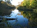
A quiet stretch of the Queanbeyan River near the suspension footbridge, Queanbeyan.


